

Foogy Start, Mild This Afternoon With a few Showers, Cooler to Start the Work Week
Good morning! Dense fog is relatively widespread across much of North and Central Alabama this morning as clearing skies overnight allowed temperatures near the surface to quickly cool to the dewpoint, allowing the relatively moist atmosphere to condense. As a result, visibilities are below ¼ mile in many spots. Use caution if you are heading out anywhere this morning. The fog should burn off by 8-9 a.m. in most spots.
CHANGEABLE SUNDAY: After the fog burns off, ample sunshine will prevail for a short while into the early afternoon before our next weather maker brings clouds back into the area. This weather maker will be an upper-level trough swinging across in the fast west-southwesterly flow tonight. It will pick up enough Gulf moisture to shake out a few showers late this afternoon and evening. Those showers should arrive in West Alabama by early afternoon and will overspread the area during the afternoon and evening. Cooler and drier air will start arriving overnight, and lows by tomorrow morning will be in the 30s.
COOL MONDAY: Highs tomorrow will have a hard time getting out of the 40s, despite an increasing supply of sunshine. Winds out of the northwest at 8-16 mph will make it feel even cooler.
FREEZE TUESDAY MORNING: Lows Tuesday morning will be in the middle and upper 20s. And highs will once again have a hard time reaching 50 degrees.
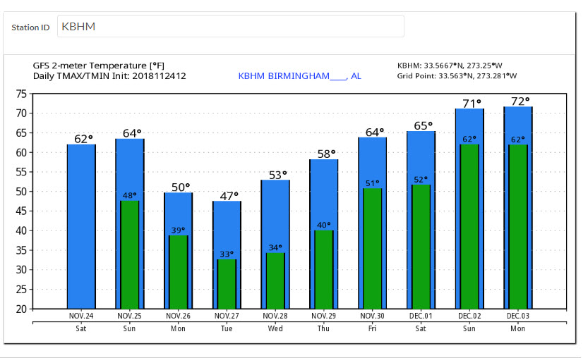
WARMUP INTO THE WEEKEND: As surface high pressure slides east of Alabama by Wednesday, our winds will become more southerly and temperatures will slowly start to moderate. We will be in the lower 50s Wednesday and middle 50s Thursday. The warmup will begin in earnest on Friday, with highs near 60F.
SHOWERS THURSDAY? The GFS is hinting at some showers occurring late Thursday as a fast-moving system swings across. It remains to be seen if this will be a reality. The Euro doesn’t think so.
WEEKEND STORM SYSTEM: A decent low-pressure system moves into Missouri on Saturday, setting the stage for showers and storms in the warm sector of the low, including here in Alabama. A strong low-level jet, strong winds aloft and decent instability point to the possibility of strong to severe storms. It is too early to determine how real this threat is, so we will be watching data as we go through the week.
VOODOO TERRITORY: Look for another couple of wet weather systems to affect the Southeast on the weekend of the 7th-9th. At least one of them should bring rain to Central Alabama.
TROPICS: There is a disturbance southwest of Bermuda, but the NHC gives it a 0% chance of developing.
GULF COAST WEATHER: After some showers today and tonight, the rest of the week looks good along the beautiful beaches of Alabama and Northwest Florida. It will be cool, like here, with highs in the 50s Monday and Tuesday, 60s on Wednesday, and approaching 70F from Thursday into the weekend. Lows will be in the 30s, 40s and 50s. The next chance of rain comes late Saturday. Water temperatures are cooling off. They are now near 60F.
Click here to see the Beach Forecast Center page.
WEATHERBRAINS: This week, the panel will entertain Dr. Ken Dewey of the University of Nebraska. Check out the show at www.WeatherBrains.com. You can also subscribe on iTunes. You can watch the show live at live.bigbrainsmedia.com You will be able to see the show on the James Spann 24×7 weather channel on cable or directly over the air on the dot 2 feed.
ON THIS DATE IN 1950: Extreme cold occurred in the deep south. Birmingham had a reading of 5 degrees. -1 on Sand Mountain and -2 at Valley Head AL. It was the first time that sub-zero readings had occurred in North Alabama in November. The bitter cold was accompanied by two inches of snow across North Alabama. Follow my weather history tweets on Twitter. I am @wxhistorian at Twitter.com.
Category: Alabama's Weather, ALL POSTS
About the Author (Author Profile)
Bill Murray is the President of The Weather Factory. He is the site's official weather historian and a weekend forecaster. He also anchors the site's severe weather coverage. Bill Murray is the proud holder of National Weather Association Digital Seal #0001 @wxhistorianSubscribe
If you enjoyed this article, subscribe to receive more just like it.


