


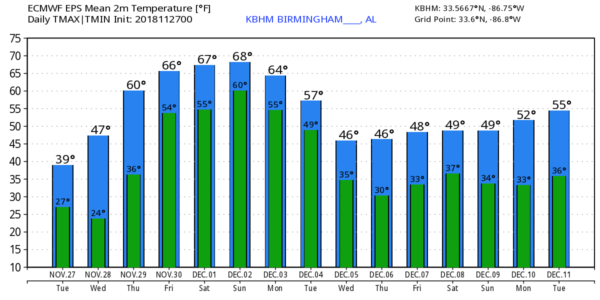
WELL BELOW AVERAGE: Despite a sunny sky we project a high only in the 38-44 degree range over the northern half of Alabama today, well below the average high of 62 for November 27 (at Birmingham). A brisk north wind of 10-20 mph will make it feel even colder.
Tonight will feature another significant freeze statewide; most places will see a low in the 20s, but colder spots across North Alabama will dip into the teens for the first time this year with a clear sky and light wind. Then, during the day tomorrow, we rise to a high around 50 degrees with a good supply of sunshine.
Clouds will increase across the state Thursday as moist air returns from the Gulf of Mexico, and a few scattered showers could break out late in the day or Thursday night… nothing too heavy or widespread. The high Thursday will be in the 57-61 degree range.
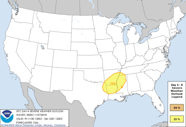
FRIDAY AND THE WEEKEND: A rather dynamic storm system will become organized west of the state Friday, and strong to severe storms are possible west of the state. SPC has a risk of severe weather defined in a broad zone from Shreveport to Columbus, Mississippi.
In Alabama Friday, the day will be mostly cloudy with showers possible; the high will be in the upper 60s. A few spots could touch 70 degrees.
Strong storms will push into Alabama early Saturday morning, and they could pack a punch. But, the latest model guidance suggests the main window for heavier storms will come from 4:00 a.m. until 12:00 noon, at a time when the atmosphere tends to be most stable. Hopefully, this will reduce the chance of severe storms in our state, and for now SPC does not have any part of Alabama in a risk on their “Day 5” outlook for Saturday. But, with strong wind fields and good dynamic support, we will need to keep a close eye on the thunderstorms as they enter Alabama Saturday morning.
Rain should end from west to east Saturday afternoon, and the high will be up in the low to mid 70s as mild air will continue to cover the state.
Saturday night and Sunday look dry, and the weather stays unseasonably mild. We rise into the 70-75 degree range again on Sunday with a good supply of sunshine.
NEXT WEEK: Another system will bring rain, and potential for strong thunderstorms, to Alabama late Monday and Monday night… way too early to know if this will be a severe weather threat for the state. Then, Tuesday will be sharply colder with a clearing sky. The rest of the week looks cold and dry with highs generally in the 40s, and lows in the 20s. See the Weather Xtreme video for maps, graphics, and more details.
TROPICS: All is quiet across the Atlantic basin, and the hurricane season ends Friday.
BEACH FORECAST: Click here to see the AlabamaWx Beach Forecast Center page.
WEATHER BRAINS: Don’t forget you can listen to our weekly 90 minute show anytime on your favorite podcast app. This is the show all about weather featuring many familiar voices, including our meteorologists here at ABC 33/40.
CONNECT: You can find me on all of the major social networks…
Facebook
Twitter
Instagram
Pinterest
Snapchat: spannwx
I have a weather program this morning at Vernon Intermediate School in Lamar County… look for the next Weather Xtreme video here by 4:00 this afternoon. Enjoy the day!


