

The Year of Michael and Florence: 25 Interesting Facts About the 2018 Atlantic Hurricane Season
The 2018 Atlantic Hurricane Season is in the books. It came to a close yesterday after producing 15 named storms, 8 of which reached hurricane status and 2 which went on to become major hurricanes (category 3 or greater). This is slightly above average for the Atlantic. Long-term averages include 11.7 named storms, 6.3 hurricanes, and 2.4 major hurricanes, according to NOAA’s Hurricane Research Division data which covers the period since reliable data became available (1966-2017).
In an average year, 1.7 hurricanes and 0.6 major hurricanes make landfall in the United States. Four named storms struck the United States in 2018, including Tropical Storm Alberto, Tropical Storm Gordon, Major Hurricane Florence and Major Hurricane Michael, which devastated the Florida Panhandle coast and caused severe wind damage into southeastern Alabama and southern Georgia.
Here are capsules on each storm and interesting facts from each:
Alberto (5/25-31) Tropical Storm (65 MPH): Formed in the western Caribbean Sea and moved northward across the Gulf of Mexico and made landfall on the Florida Gulf Coast on the 28th. Weakened into a tropical depression soon after landfall and moved northward before finally losing its tropical characteristics over Central Michigan.
…INTERESTING FACT #1: This was the fourth straight year that at least one named storm occurred before the official start of the hurricane season (June 1).
…INTERESTING FACT #2: Originally classified as a subtropical storm, Alberto was later changed to a tropical storm before landfall.
…INTERESTING FACT #3: Alberto was only the fourth named storm to form in the Gulf of Mexico and the first since 1976. The system in 1976 was not identified in real time, added as a subtropical storm after the season.
…INTERESTING FACT #4: Alberto brought strong winds, high tides and rain to the Panama City area, ruining Memorial Day for many and acting as a prelude for what would happen five months later.
Beryl (7/4-16) Hurricane (80 MPH): Beryl formed out in the eastern Atlantic on Independence Day and made a long trek across the ocean before curving off to the north and northeast well before approaching the US Mainland. Beryl became a weak hurricane briefly on the 5th and through the 6th before rapidly weakening into a tropical storm and eventually a wave. Beryl then spent the next 6 days of its journey as a tropical wave before briefly becoming a subtropical storm on the 14th. During that time as a wave, Beryl brought heavy rains to Haiti and the Dominican Republic on the 10th when making the northward turn. Beryl finally weakened into an open low and eventually degenerated on the 15th.
…INTERESTING FACT #5: Beryl was the furthest southeast that a named storm had formed so early in the season.
Chris (7/6-12) Hurricane (105 MPH): Tropical Depression Three formed on July 6th off the North Carolina Coast. It meandered off the coast of the Carolinas for three days, becoming a hurricane before racing off to the northeast. It reached a maximum intensity of 105 mph and 970 millibars.
…INTERESTING FACT #6: There have been six storms named Chris in the Atlantic. 2018 Chris was the strongest of the six.
Debby (8/7-9) Tropical Storm (50 MPH): Subtropical Storm Debby formed from a non-tropical low over the Atlantic. The system became tropical but weakened as it moved northeast over open water.
…INTERESTING FACT #7: There were a record seven storms in the season that were subtropical at some point during their lives.
Ernesto (8/15-18) Tropical Storm (45 MPH): Ernesto started out as a subtropical depression as well and remained over he North Atlantic.
…INTERESTING FACT #8: Ernesto was the third named storm in a row to form north of latitude 30N, which is unusual. The reason? Sea surface temperatures across the main development region of the Atlantic were well below average early in the season.
…INTERESTING FACT #9: In fact, the zero named storm formations in the Atlantic south of 30N in August was the first time that had happened since 1997.
Florence (8/31-9/17) Major Hurricane (140 MPH): Hurricane Florence caused historic flooding in portions of South and North Carolina. Several rivers in the Carolinas reached or approached record levels. Several rivers took 2-3 weeks to fall below flood stage.
…INTERESTING FACT #10: Florence broke statewide rainfall records for tropical cyclones in both North Carolina (35.93”) and South Carolina (23.63”).
…INTERESTING FACT #11: When Florence reached category four status, it marked the fifth straight year that the Atlantic has seen a cat four.
Gordon (9/3-9/8) Tropical Storm (70 MPH): On August 30th, the National Hurricane Center began monitoring a disturbance over the northwestern Caribbean. By September 2nd, they had identified it as a Potential Tropical Cyclone and issued tropical storm watches along the northern Gulf Coast. The tropical storm would make landfall near the Alabama/Mississippi border on September 4th with top winds of 70 mph.
…INTERESTING FACT #12: Gordon was a prime example of the NHCs new Potential Tropical Cyclone products, allowing forecasters to issue watches or warnings even before a system is classified.
Helene (9/7-9/16) Hurricane (110 MPH): The powerful wave that would become Helene was evident well before it left the African Coast. The developing system impacted the Cape Verde islands before turning north and northeast over the eastern Atlantic. It would go on to impact Ireland and the United Kingdom, but in a weakened state.
…INTERESTING FACT #13: Helene was the easternmost hurricane to form in the main development region of the Atlantic.
…INTERESTING FACT #14: Helene would interact with Tropical Storm Joyce in an example of the Fujiwhara effect, an amazing dance where two tropical cyclones effectively rotate around each other.
Isaac (9/7-15) Hurricane (75 MPH): Hurricane Isaac formed in the eastern Atlantic, briefly became a hurricane, but weakened before reaching the Lesser Antilles. The system would dissipate over the Caribbean south of Haiti.
…INTERESTING FACT #15: There were 3 hurricanes occurring simultaneously (Florence, Helene and Isaac) on September 10th, the 11th time in history.
Joyce (9/12-19) Tropical Storm (50 MPH): Tropical Storm Joyce formed over the eastern Atlantic and meandered northward, then west and eventually north over the open ocean.
…INTERESTING FACT #16: For the first time since 2008, the Atlantic has four named storms simultaneously (Florence, Helen, Isaac and Joyce).
…INTERESTING FACT #17: The five named storms that formed between September 1-12 was tied for the most with 1999.
Kirk (9/22-29) Tropical Storm (60 MPH): Tropical Storm Kirk would have been a classic Cape Verde storm, but cold water and a rapid forward speed caused it to weaken to a wave before regenerating and hitting St. Lucia. The system quickly dissipated over the eastern Caribbean.
…INTERESTING FACT #18: Kirk became a named storm at 8.3N, one of the lowest formations on record.
Leslie (9/23-10/13) Hurricane (90 MPH): Hurricane Leslie meandered around the North Central Atlantic for over two weeks.
…INTERESTING FACT #19: Leslie was the longest-lived named storm of the season at 16.5 days.
…INTERESTING FACT #20: Leslie caused tropical storm warnings to be issued for the island of Madeira for the first time in their history.
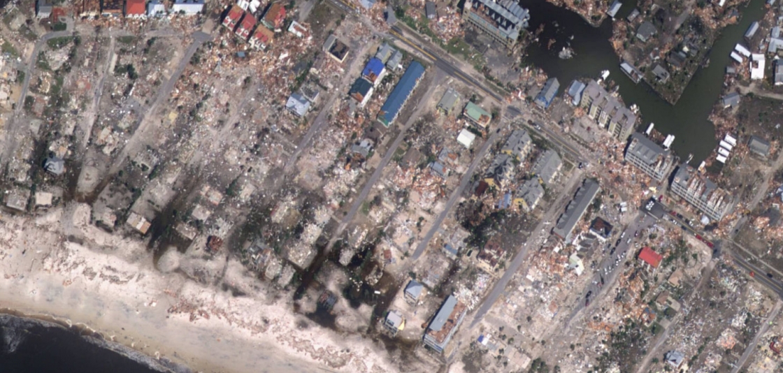
Incredible destruction from Hurricane Michael at Mexico Beach, Florida
Michael (10/7-12) Major Hurricane (155 MPH): On October 2nd, the National Hurricane Center began monitoring the disturbance that would become Major Hurricane Micheal while it was over the southwestern Caribbean. They would issue the first advisory on the potential tropical cyclone on Saturday, October 6th. It became a tropical depression the next morning and strengthened into a tropical storm a few hours later. Michael became a hurricane as it approached the western tip of Cuba. It moved northward over the Gulf of Mexico and became a major hurricane on the 9th and reached category four status at midnight that night. A nightmarish situation developing as the storm continued to intensify right up until landfall at 1 p.m. on Wednesday, October 10th near Mexico Beach, Florida.
…INTERESTING FACT #21: Michael was the first category four hurricane to make landfall in the Florida Panhandle.
…INTERESTING FACT #22: At 919 millibars, Michael was the 3rd lowest central pressure at landfall for a U.S. Hurricane. The 155 mph sustained wind at landfall was the 4th strongest.
…INTERESTING FACT #23: Michael was the third category four hurricane in the Atlantic in two years. That is the most ever in a two-year span.
Nadine (10/9-13) Tropical Storm (65 MPH): Nadine remained over the open waters of the eastern Atlantic for its lifetime.
…INTERESTING FACT #24: Nadine was the easternmost named storm to form so late in the season in the Atlantic.
Oscar (10/27-31) Hurricane (105 MPH): Oscar remained over open waters of the central Atlantic.
…INTERESTING FACT #25: Oscar was the only storm of the season that was not interesting in any way.
Other notes about the season:
…87.5 named storm days in 2018. This marks the 3rd straight year that the Atlantic has 80+ named storm days. The last time that happened was 2003-05.
…NOAA and the Navy launched the most unmanned gliders ever in support of Atlantic hurricane forecasts.
The 2018 season will be remembered as the year of Florence and Michael. All from a season that was originally expected to be below normal.
Category: ALL POSTS, Met 101/Weather History, Tropical
About the Author (Author Profile)
Bill Murray is the President of The Weather Factory. He is the site's official weather historian and a weekend forecaster. He also anchors the site's severe weather coverage. Bill Murray is the proud holder of National Weather Association Digital Seal #0001 @wxhistorianSubscribe
If you enjoyed this article, subscribe to receive more just like it.


