

Colder Days Ahead; Rain By The Weekend
TURNING COLDER: This afternoon features a good supply of sunshine across Alabama with temperatures in the 50s and 60s, but colder air will filter into the state tonight, and most communities will be at or below freezing early tomorrow morning.
Look for sunny cool days and fair cold nights tomorrow through Thursday; the high tomorrow and Wednesday will be in the 45-50 degree range, followed by mid 50s Thursday. Keep in mind the average high for today in Birmingham is 59. Morning lows will remain below freezing each morning through early Thursday over the northern half of the state.
Clouds will increase Friday ahead of a developing storm system to the west, and rain could reach the state late Friday night.
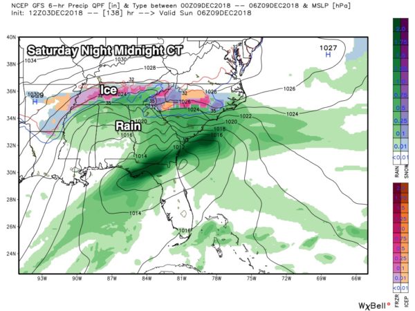
COLD, WET WEEKEND: A surface low is forecast to move along the Gulf Coast, setting up a cold, soaking rain for Alabama Saturday and Saturday night. Temperatures will be in the 40s over North Alabama, with 50s over the southern counties of the state. Rain amounts of around one inch are likely, and it will be pretty much an “all day” kind of rain if you are planning something outdoors.
We should mention that some ice/snow issues are likely over parts of Arkansas and Tennessee with this system, so be aware of that if you are traveling to the north.
The low will move east of Alabama Sunday, and the day will be cloudy and cold with a chance of some lingering light rain. Many communities over North Alabama could very well hold in the 30s all day, and there is some risk of a “wintry mix” near the Tennessee state line Sunday morning. Way too early to know if we will see any impact, just something to watch for now. The more significant snow/ice issues should be north of Alabama.
NEXT WEEK: Monday will be a cold, mostly cloudy day, but the rest of the week looks generally dry with slowly moderating temperatures. See the Weather Xtreme video for maps, graphics, and more details…
ON THIS DATE IN 1983: As the Iron Bowl was being played at Legion Field in Birmingham, NWS radar at Centreville showed a well defined hook echo heading directly toward the stadium. Legion Field Public Address announcer Simpson Pepper read the warning over the loudspeakers but the game was not stopped. By ten minutes to go in the game, the rain was coming down in torrents as Auburn tried to control the ball and win the game in the horrible conditions as they clung to a 23-20 lead. The rain began to fall so heavily that you could barely see the field on the cameras.
Fortunately, the storm did not produce a tornado in western Birmingham, or the results would have been catastrophic. But later, the same storm dropped an F3 tornado that heavily damaged the Winn Dixie store at Sky City in Oxford, killing two people. A total of seven tornadoes touched down across the state that afternoon and evening. Auburn went on to win the game 23-20.
BEACH FORECAST: Click here to see the AlabamaWx Beach Forecast Center page.
WEATHER BRAINS: Don’t forget you can listen to our weekly 90 minute show anytime on your favorite podcast app. This is the show all about weather featuring many familiar voices, including our meteorologists here at ABC 33/40.
CONNECT: You can find me on all of the major social networks…
Facebook
Twitter
Instagram
Pinterest
Snapchat: spannwx
I enjoyed seeing the third graders today at Gwin Elementary in Hoover…. be looking for them on the Pepsi KIDCAM today at 5:00 on ABC 33/40 News! The next Weather Xtreme video will be posted here by 7:00 a.m. tomorrow…
Category: Alabama's Weather, ALL POSTS, Weather Xtreme Videos
About the Author (Author Profile)
James Spann is one of the most recognized and trusted television meteorologists in the industry. He holds the AMS CCM designation and television seals from the AMS and NWA. He is a past winner of the Broadcast Meteorologist of the Year from both professional organizations.Subscribe
If you enjoyed this article, subscribe to receive more just like it.


