

Cold And Wet Is The Word For Your Saturday
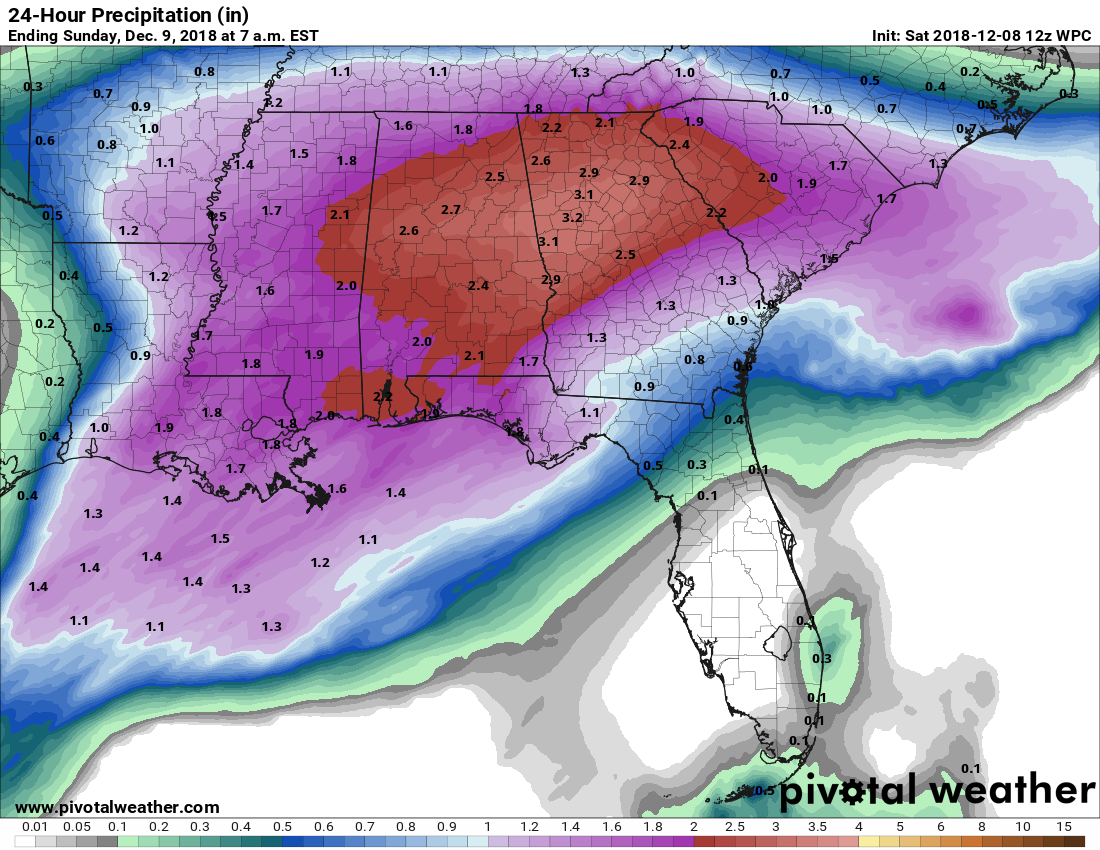
TODAY: A center of low pressure will be over Lake Pontchartrain pulling plenty of moisture up into Central Alabama. We’ll start off with light to moderate showers through the morning hours today, but rain will become heavier through the day. We could see rainfall amounts topping out in the 2.00-2.75 inch range across the area for the next 24-hours. Rain could be heavy enough that there is a slight risk of some flash flooding possible especially in poor drainage areas and in locations that are known to collect water rather quickly. Daytime highs will top out in the mid-40s to the lower 50s across the area from north to south. Rain will begin to diminish somewhat in coverage late tonight and through the overnight hours, but shower chances will remain elevated as Gulf moisture continues to wrap around the north side of the low. Overnight lows will be in the upper 30s to the mid-40s.
SUNDAY: Sunday is trending a little drier in this model run as most of the shower activity will have moved over into the Carolinas and much of Georgia. We’ll have some lingering light showers and drizzle wrapping around the back side of the low that may affect the northeastern parts of the area, while the rest of Central Alabama will be dry and cold with cloudy skies. Highs will be in the 40s across the area with overnight lows in the 30s.
MONDAY: The GFS is trying to pull some moisture back into the northeastern parts of the area for Monday afternoon, so we’ll mention a small chance of a stray light shower or two mainly for locations east of I-65 and north of I-20. Those small chances will persist through the evening hours but should move back out by midnight. We may see a snow flurry or two, but that is it. Afternoon highs will be in the mid to upper 40s with overnight lows in the mid-20s to the mid-30s.
TUESDAY & WEDNESDAY: While temperatures remain cool across the area on Tuesday, all rain will be out of the area and skies will be sunny throughout the day. Afternoon highs topping out in the upper 40s to the mid-50s. A little warmer for Wednesday as we’ll have a very small zone of ridging in place over the area. Skies will be mostly sunny with afternoon highs in the mid to upper 50s across the area for the most part.
THURSDAY & FRIDAY: The next system will be getting its act together on Thursday to our west as a surface low will be over the western parts of Oklahoma at midday. We may have some scattered light showers move across the area during the afternoon hours, but rain will start to increase in coverage during the late night and overnight hours. Afternoon highs will be in the mid-50s to the lower 60s. Friday will start off with rain during the morning hours with maybe just enough instability thrown in for a few claps of thunder. Earlier model runs had the associated low pressure moving through the northern portions of the southeast, but this run has the low moving up into the Great Lakes region as of noon. Rain will be pushing out of the area and all of Central Alabama should be dry by sunset. Highs will top out in the lower 50s to the lower 60s across the area.
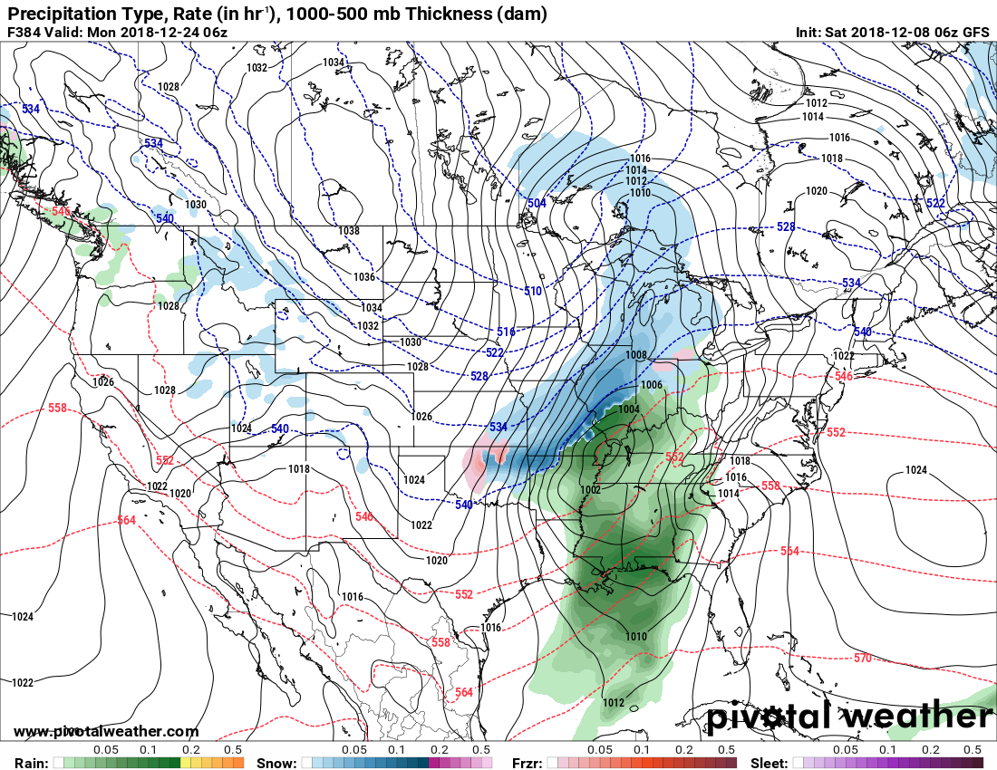
VOODOO LAND: Taking a brief step out into Voodoo Land, it looks like we’ll have a good bit of dry weather after the rain moves out on Friday, with our next possible rain chance late on the night of the 20th and once again at the end of the forecast period 384 hours out on the evening of the 23rd and through the morning of Christmas Eve. But this is just a model trend at this point, not an official forecast.
BEACH FORECAST CENTER: Get the latest weather and rip current forecast for the beaches from Fort Morgan to Panama City on our Beach Forecast Center page. There, you can select the forecast of the region that you are interested in.
WE’RE HAVING A RECORD-BREAKING YEAR… ADVERTISE WITH US TODAY!: Don’t miss out! We have enjoyed nearly 19 MILLION page views on AlabamaWx.com so far in 2018. We can customize a creative, flexible and affordable package that will suit your organization’s needs. Contact Bill Murray at (205) 687-0782.
E-FORECAST: Get the Alabama Wx Weather Blog’s Seven-Day Forecast delivered directly to your inbox by email twice daily. It is the most detailed weather forecast available in Central Alabama. Subscribe here… It’s free!
CONNECT ON SOCIAL MEDIA: You can find the AlabamaWx Weather Blog on the major social media networks:
Facebook
Twitter
WEATHERBRAINS: Don’t forget you can listen to our weekly 90 minute netcast anytime on the web at WeatherBrains.com or on iTunes, Stitcher, or Spotify. This is the show all about weather featuring many familiar voices, including the meteorologists at ABC 33/40.
Category: Alabama's Weather, ALL POSTS, Weather Xtreme Videos
About the Author (Author Profile)
Scott Martin is an operational meteorologist, professional graphic artist, musician, husband, and father. Not only is Scott a member of the National Weather Association, but he is also the Central Alabama Chapter of the NWA president. Scott is also the co-founder of Racecast Weather, which provides forecasts for many racing series across the USA. He also supplies forecasts for the BassMaster Elite Series events including the BassMaster Classic.Subscribe
If you enjoyed this article, subscribe to receive more just like it.


