

Afternoon Weather Xtreme Video: Rain at Times Through Tomorrow Evening; Lingering Light Rain into Saturday
CONDOLENCES TO THE SPANNS: I know you all are joining to together with heavy hearts as James and the Spann family say goodbye to his Mom, Carolyn, who left this Earth for a heavenly kingdom early Sunday morning. Our thoughts and prayers are with James, Karen, J.P., and Ryan today as they mourn her passing.
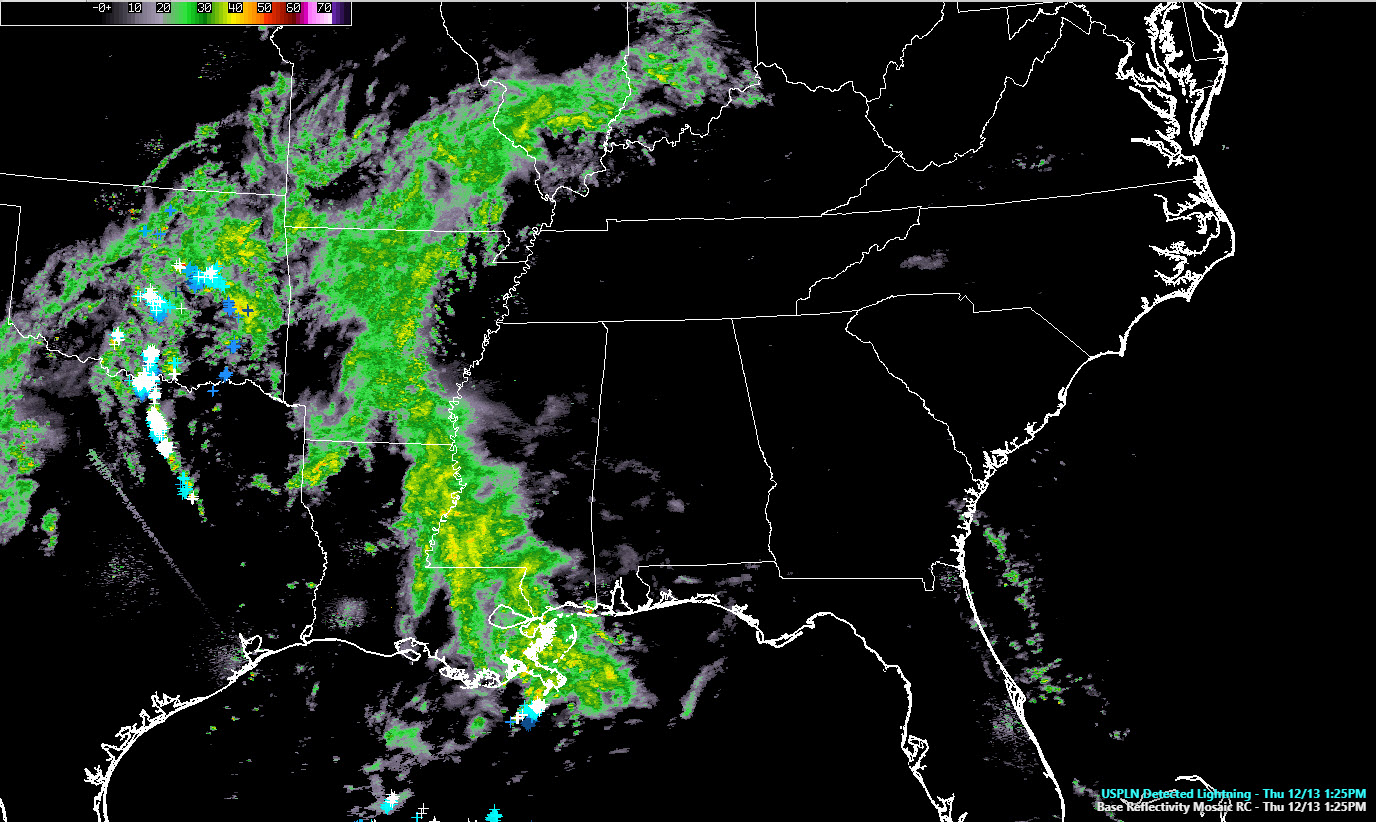
GOING BOWLING: We decided on the WeatherBrains podcast last night that “Bowling Ball” is our new favorite weather word. We typically use it to describe large upper-level lows that tend to barrel across the landscape, creating woes for weather humans. One such low is heading our way on this Thursday afternoon. It is forming over North Texas and southern Oklahoma even as we speak. The deep trough that spun it up is swinging across the Plains right now and it will bring a round of wet weather to the Southeast over the next 24 hours.
ON THE WEATHER MAPS: The surface low that is being generated by this system is intensifying over northeastern Texas this afternoon. It is running up the back of very strong high pressure centered over Maine. The pressure gradient between the deepening low and the strong high is causing surface winds to kick up just to our west and we will see those gusty winds pick up out of the east this evening, averaging 8-16 mph and gusting as high as 25 mph at times. Ridge may even see higher gusts.
NO REPEAT OF SATURDAY NIGHT: While we don’t expect widespread tree damage like occurred with the wake/ low/gravity wave event Saturday night, there could be a few reports of downed trees tonight, especially given our current wet soil conditions.
NAILING DOWN A RAINY FORECAST: A few light showers moved across the area late this morning, and more will continue to form this late this afternoon, but the main rain and storms are moving through southern Mississippi and eastern Louisiana. Rain and some thunder will increase from the southwest after dark tonight, with rain reaching the Birmingham area between 7-9 p.m. Rain will increase in the I-20 Corridor through midnight and into the early morning hours. Showers will be likely into the morning hours on Friday. Rainfall amounts should average one-quarter of an inch by morning. After highs in the 50s this afternoon, lows tonight won’t fall much, dropping into the 47F-54F range.
THE FACTS ON FRIDAY: Tomorrow will be a mostly cloudy, relatively mild day with highs in the upper 50s and lower 60s. Rain chances will remain high throughout the day. At least one band of heavy showers will move through as the low approached Friday afternoon. Rainfall amounts will average less than one-half inch during the day. There could be a little thunder mixed in with that band of showers tomorrow afternoon. Any chances for severe weather should be limited to the Gulf Coast, although we will be keeping an eye on the possibility further to the north. Showers will stay with us through Friday night as the bowling ball lumbers across.
SATURDAY LINGERERS: A little bit of light rain and drizzle will linger into Saturday as the upper low moves into the Mid-Atlantic. Clouds should begin decreasing Saturday night, and after highs in the lower 50s Saturday afternoon, overnight lows will drop into the lower 40s Sunday morning. A few normally colder spots will be well down into the 30s.
SUNDAY: Sunday won’t be a bad day, with increasing sunshine, and highs in the middle 50s.
EXTENDED DRYING OUT PERIOD: It looks like high pressure will retain control of Alabama’s weather through much next week, giving us fine weather. Our next chance of rain looks like it will be a quick hitting shot on the 23rd. Temperatures are going to be seasonally cool through the period, with highs generally in the 50s and lows in the 30s.
CHRISTMAS WEATHER: Looks fir, dry and cool for Christmas Eve. Highs will be in the 50s. Lows in the 30s.
GULF COAST WEATHER: Showers will persist along the coast through Saturday. Severe weather is possible tonight. Lows tonight will only drop to near 60F. The rest of the week will be in the 40s. Highs will be in the 60s all week. Water temperatures are quite brisk: around 55F at Dauphin Island. Rip currents are also a big threat through Friday night.
Click here to see the Beach Forecast Center page.
CENTRAL ALABAMA NWA: The local Chapter’s Holiday Party will be Monday night (the 17th) at 6:00 p.m. at the Hilton Garden Inn at Liberty Park off I-459. Come for 90 mins of fellowship and barbecue. Instructions of RSVPing may be found here.
WEATHERBRAINS: A great time was had by all last night on the WeatherBrains podcast. The event went into overtime and was even still going strong when James made it back from doing television! Meteorologists Robert Bradford and Tina Stall from the National Weather Service in Honolulu gave us a peek into weather forecasting in paradise. They were joined by their friend Jeremy Bower, who dreamed up the show and made it happen. Learn more about severe weather in Hawaii, including thunderstorms, tornadoes, heavy rain and dangerous surf as well as hear about trade winds and the infamous Kona Low. Check out the show at www.WeatherBrains.com. You can also subscribe on iTunes. You can watch the show live at live.bigbrainsmedia.com You will be able to see the show on the James Spann 24×7 weather channel on cable or directly over the air on the dot 2 feed.
ON THIS DATE IN 1977: Twenty nine people including fourteen University of Evansville basketball players and coach Bobby Watson were killed when their plane crashed shortly after takeoff in dense fog from the Evansville, Indiana Airport. Follow my weather history tweets on Twitter. I am @wxhistorian at Twitter.com.
Category: Alabama's Weather, ALL POSTS
About the Author (Author Profile)
Bill Murray is the President of The Weather Factory. He is the site's official weather historian and a weekend forecaster. He also anchors the site's severe weather coverage. Bill Murray is the proud holder of National Weather Association Digital Seal #0001 @wxhistorianSubscribe
If you enjoyed this article, subscribe to receive more just like it.


