

Strong/Severe Storms Possible Later Today
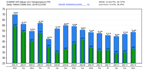
ACTIVE DAY TO WRAP UP 2018: Temperatures are mostly in the mild 60s across Alabama early this morning, and we project a high in the 70-74 degree range for most of the state this afternoon. The late December warmth will help to create an unstable atmosphere, and with the approach of a storm system, we will have potential for strong to severe thunderstorms this afternoon and into early tonight.
SPC has defined the standard “slight risk” (level 2/5) for areas along and north of I-59, with a “marginal risk” (level 1/5) down to Lafayette, Luverne, and Mobile.
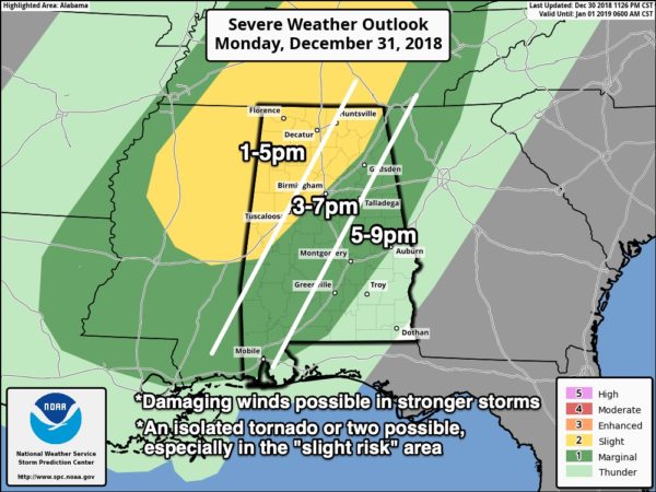
*The main window for severe storms will come from 1:00 until 9:00 p.m… with the threat initially over Northwest Alabama, then shifting to the southeast through the afternoon and evening hours.
*The primary threat will come from strong, potentially damaging straight line winds. However, an isolated tornado or two is possible, especially in the “slight risk” area across North and West Alabama.
*Pressure gradient winds, away from thunderstorms, will ramp up this afternoon, averaging 12-22 mph, possibly gusting to 30 mph at times. With the saturated soil conditions, this could result in a few downed trees and power lines.
*Rain amounts will be around 1/2 inch for most places today, with isolated totals to one inch. Widespread flooding issues are not expected, but a few isolated issues are possible.
Showers and storms will end later tonight as a surface front passes through.
TOMORROW: The day will be mostly dry with only an outside risk of a shower, but the sky will remain generally cloudy. A few intervals of sun are possible during the afternoon, and the high will be in the mid 60s.
MORE RAIN LATER THIS WEEK: Colder air creeps into Alabama Wednesday; the high will be in the 50-55 degree range with clouds hanging tough. And, a wave on the front to the south will bring more rain into the state beginning Wednesday afternoon. Unfortunately rain will continue to fall Wednesday night, much of the day Thursday, and lingering into Friday morning. The air will be cool and stable with temperatures generally in the 48-55 degree range while the rain falls, so no worries with severe thunderstorms.
Additional rain amounts Wednesday through Friday will be in the 2-3″ range for North Alabama, with 1-2″ possible for the southern counties of the state. Some flooding issues will be possible again along already swollen creeks and streams.
DRIER WEEKEND: The weekend looks very nice. Lots of sunshine Saturday and Sunday; the high Saturday will be close to 60, followed by mid 60s Sunday. Morning lows will be in the 30s.
NEXT WEEK: It actually looks like dry weather could stay in place for a decent part of the week, giving Alabama a much needed chance to dry out. See the Weather Xtreme video for maps, graphics, and more details.
WET DECEMBER: As of this morning, Birmingham’s rain total for December is 10.26″, making it the 8th wettest December on record. Here is a look at the top 10 wettest Decembers (based on data from Birmingham)…
December 1961 13.98″
December 1932 13.85″
December 1983 12.63″
December 1967 11.49″
December 1942 11.03″
December 1926 10.61″
December 2015 10.53″
December 2018 10.26″
December 1920 9.57″
December 1919 9.56″
With more rain coming, December 2018 might make it to number 5 on this list.
BEACH FORECAST: Click here to see the AlabamaWx Beach Forecast Center page.
WEATHER BRAINS: Don’t forget you can listen to our weekly 90 minute show anytime on your favorite podcast app. This is the show all about weather featuring many familiar voices, including our meteorologists here at ABC 33/40.
CONNECT: You can find me on all of the major social networks…
Facebook
Twitter
Instagram
Pinterest
Snapchat: spannwx
We are on a holiday schedule, so just one video today, but we will forecast frequent updates on the severe weather situation throughout the day… stay tuned!
Category: Alabama's Weather, ALL POSTS, Weather Xtreme Videos
About the Author (Author Profile)
James Spann is one of the most recognized and trusted television meteorologists in the industry. He holds the AMS CCM designation and television seals from the AMS and NWA. He is a past winner of the Broadcast Meteorologist of the Year from both professional organizations.Subscribe
If you enjoyed this article, subscribe to receive more just like it.


