

Sunday Weather Xtreme Video: A Passing Shower Monday Night, Then Colder But Dry Until Friday
Sunday morning, January 6, 2019
Forecaster: Bill Murray
Saturday was a very nice day across Central Alabama, with a good supply of sunshine and temperatures in the 50s and lower 60s. It actually had just a tiny bit of a spring feel to it, at least if you were standing in the sun. Today and tomorrow promise some more enjoyable conditions.
TODAY’S WEATHER
More sunshine is on tap for today with high running a few degrees ahead of those of yesterday. Highs will range between 62-67F across the area. Overnight lows tonight will be generally in the lower 40s with a few upper 30s in colder spots under fair skies.
MONDAY & TUESDAY
Low pressure moving through the gReat Lakes will push a fairly dry cold front through Alabama Monday night and early Tuesday. There could be enough moisture for a few light showers across the northern half of the area Monday night, but rainfall amounts will be light. Overnight lows will hold in the upper 40s and lower 50s with increased cloud cover providing a blanket over the area.
NATIONAL CHAMPIONSHIP GAME
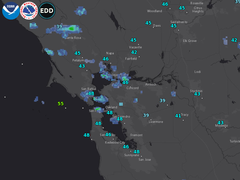
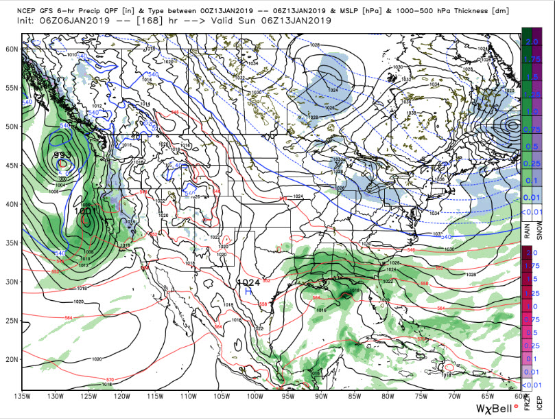
‘Bama fans out west for the National Title game will find the going miserable today with rain and wind in the Bay area. Wind advisories are in effect for winds gusting as high as 35 mph and rain will be heavy at times today and tonight. It should diminish by Monday morning with just a few showers up through noon. Things should be dry for the game though. Highs today in the upper 50s will reach into the lower 60s tomorrow. Rain returns on Tuesday as everyone makes the trek back home.
WEDNESDAY & THURSDAY
The ridging begins to build again out to our west and that will bring us dry but cooler weather across Central Alabama. Wednesday will feature a good bit of sunshine with just a few clouds and highs in the upper 40s to the mid-50s across the area from north to south. There will even be more sunshine on Thursday, but highs will remain cool, also topping out in the upper 40s to the mid-50s.
FRIDAY
The ridging flattens out again as the pattern goes zonal, and there will be a small impulse that will begin to make its way towards Central Alabama on Friday. The latest runs of the GFS are faster with this system, and hint at a little rain/snow mix into northern Mississippi and northwestern Alabama early Friday morning. That bears watching. It will change to rain though as temperatures warm during the morning and we’ll have a very small chance of a few passing showers through the day. Afternoon highs will be in the upper 40s to the mid-50s across the area from north to south.
WEEKEND OUTLOOK
Indications are that another Gulf low may spin up by Friday night however, slowly spreading additional rain across Alabama and the Southeast on Saturday. It looks like the heaviest rain could be Saturday night. It takes most of Sunday to clear out the rain.
VOODOO LAND
The longer range part of the GFS shows another disturbance dropping down from the northwest on Saturday the 19th, bringing a chance of rain with it. There could be a little wintry mix perhaps in association with it as well. Will be interesting to watch.
A LITTLE FORECAST VERIFICATION
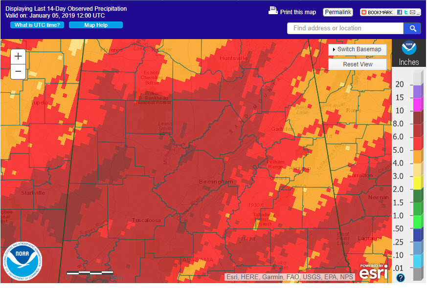
We had been preaching since mid-December that the last week of the month would be wet and stormy. It played out as forecast. 14 day rainfall amounts looked like this across the area with 5-10 inches falling across a wide area.
WEATHERBRAINS
Fantastic show this week talking about the weather of the Pacific Northwest. Boy, that must have been boring, you might say. Not so fast my friend! I promise you will learn a ton from great guests Morgan Palmer, Dr. Cliff Mass and Charlie Phillips. I know I did!
WEATHER FOLKLORE
The Spanish have a bit of interesting weather folklore. They believe that the weather on the first twelve days of January foretells the weather for the twelve months of the coming year. For example, if January 1st dawns cool and clear, then warms up during the day, then it rains that night, January will start off cool and clear, warm up at mid-month and be rainy toward the end of the month. The period is called the Cabanuelas, from the Spanish word cabana or small cabin. The twelve cabanas house the weather.
ON THIS DATE IN 2006
The record breaking Atlantic Hurricane Season of 2005 finally came to an end as Tropical Storm Zeta finally faded away in the eastern Atlantic. Zeta established several records, including longest lived December storm, longest lived tropical cyclone ever seen in January. The 2005 Hurricane Season also established a new mark for the most Accumulated Cyclone Energy index, surpassing the 1950 season.
Category: Alabama's Weather, ALL POSTS
About the Author (Author Profile)
Bill Murray is the President of The Weather Factory. He is the site's official weather historian and a weekend forecaster. He also anchors the site's severe weather coverage. Bill Murray is the proud holder of National Weather Association Digital Seal #0001 @wxhistorianSubscribe
If you enjoyed this article, subscribe to receive more just like it.


