

Brighter, Warmer Today; Showers Tomorrow
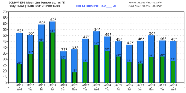
COLD START: Temperatures are below freezing over North/Central Alabama this morning, but the sky has finally clearing, and with ample sunshine we project a high in the mid 50s this afternoon, back to average values for mid-January in Alabama.
Clouds return to the state tomorrow, and a few showers are likely tomorrow afternoon and tomorrow night as a weather disturbance passes through. Moisture will be limited, and rain amounts should be on the light side, generally under 1/2 inch. The high tomorrow afternoon will be in the low 50s.
FRIDAY/SATURDAY: Friday will be a mild day with a high in the mid 60s; the sky will feature more clouds than sun, but we are not expecting much rain. Then, on Saturday, a dynamic weather system arrives a good chance of rain. While a few showers are possible Saturday morning, most of the rain will come from noon until midnight. While some thunder is certainly possible, for now we are not expecting any severe thunderstorms due to limited surface based instability. Rain amounts will be around one inch, and the high will be in the mid 60s.
MUCH COLDER SUNDAY/MONDAY: Rain ends late Saturday night, and the coldest air so far this season blows into Alabama Sunday with a brisk north wind of 15-25 mph. While we have a decent chance of the sun breaking through by afternoon, temperatures will hold in the 30s all day, with wind chill index values below freezing.
A few light snow flurries are possible over the northern third of Alabama early Sunday morning as the cold air arrives, but we expect no accumulation or impact. The incoming cold air is the big story.
Monday morning the sky will be clear and the wind light; temperatures will drop into the 15-25 degree range over North Alabama, with a freeze all the way down to the Gulf Coast. Then, during the day Monday, the sky will be sunny with a high between and 50.
REST OF NEXT WEEK: Another system will bring rain to the state later in the week, but there are huge model differences. For now we will side with the slower European model solution, with rain most likely Wednesday into Thursday. Then, another shot of cold, Arctic air arrives late in the week on Friday. See the Weather Xtreme video for maps, graphics, and more details.
ONE YEAR AGO TODAY: During the morning of January 16th, 2018, a band of light snow moved into Northwest Alabama, and then progressed toward the I-20 corridor during the afternoon as it trended toward a weakened state. Due to limited moisture content, a trace to less than 1” of snow resulted from the band on average over North Alabama. But, as the system encountered deeper moisture to the south, 2 to 4 inches of snow fell in a zone from near Grove Hill to Montgomery to Lafayette.
BEACH FORECAST: Click here to see the AlabamaWx Beach Forecast Center page.
WEATHER BRAINS: Don’t forget you can listen to our weekly 90 minute show anytime on your favorite podcast app. This is the show all about weather featuring many familiar voices, including our meteorologists here at ABC 33/40.
CONNECT: You can find me on all of the major social networks…
Facebook
Twitter
Instagram
Pinterest
Snapchat: spannwx
I will be speaking at Cullman High School this morning… look for the next Weather Xtreme video here by 4:00 this afternoon. Enjoy the day!
Category: Alabama's Weather, ALL POSTS, Weather Xtreme Videos
About the Author (Author Profile)
James Spann is one of the most recognized and trusted television meteorologists in the industry. He holds the AMS CCM designation and television seals from the AMS and NWA. He is a past winner of the Broadcast Meteorologist of the Year from both professional organizations.Subscribe
If you enjoyed this article, subscribe to receive more just like it.


