

Warmer Days Ahead For Alabama
NICE WARM-UP TODAY: Temperatures are mostly in the 20s across the northern half of Alabama this morning, but we warm into the mid 50s this afternoon as a warming trend begins. The air remains dry and the sky will be mostly sunny. Tomorrow will feature a high in the low 60s with a partly sunny sky.
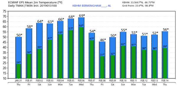
THE ALABAMA WEEKEND: Saturday promises to be a delightful day with a pretty decent amount of sun along with a high in the mid 60s for most communities. Clouds will increase Sunday, and a few scattered showers are possible, but nothing too widespread or heavy. Sunday’s high will be in the upper 60s.
NEXT WEEK: The week is looking fairly wet. An approaching surface front will bring a chance of showers, and possibly a thunderstorm Monday… and that front will stall out north of Alabama, keeping periods of rain in the forecast through Wednesday. The first half of the week will be very mild with highs well up in the 60s; a few spots could see 70 degree warmth. Then, on Thursday, another upper trough begins to form over the eastern half of the nation, pushing a cold front into the state. Rain is still possible Thursday, especially during the morning hours, and the day will be colder with temperatures holding in the 40s over the northern counties of the state. Friday looks cool and dry… see the Weather Xtreme video for maps, graphics, and more details.
UP NORTH: At 5:00 a.m. this morning Chicago (O’Hare Airport) was at -20F, with a wind chill of -37F. They actually could climb above zero today… the forecast high is 2. In Minnesota at 5:00 a.m… International Falls reports -42F; thankfully the wind there is calm.
ON THIS DATE IN 1989: The barometric pressure at Norway, Alaska reached 31.85 inches (1078.4 mb) establishing an all-time record for the North American Continent. The temperature at the time of the record was about 46 degrees below zero. Severe arctic cold began to invade the north central U.S. The temperature at Grand Fall, Montana plunged 85 degrees in 36 hours. Valentine, Nebraska plummeted from a record high of 70 degrees to zero in just nine hours. Northwest winds gusted to 86 mph at Lander WY, and wind chill readings of 80 degrees below zero were reported in Montana. Sixty-four cities in the central U.S. reported record highs for the date as readings reached the 60s in Michigan and the 80s in Kansas.
BEACH FORECAST: Click here to see the AlabamaWx Beach Forecast Center page.
WEATHER BRAINS: Don’t forget you can listen to our weekly 90 minute show anytime on your favorite podcast app. This is the show all about weather featuring many familiar voices, including our meteorologists here at ABC 33/40.
CONNECT: You can find me on all of the major social networks…
Facebook
Twitter
Instagram
Pinterest
Snapchat: spannwx
I have weather programs today at Evans Elementary in Albertville, and Snow Rogers Elementary in Gardendale… look for the next Weather Xtreme video here by 4:00 this afternoon. Enjoy the day!
Category: Alabama's Weather, ALL POSTS, Weather Xtreme Videos
About the Author (Author Profile)
James Spann is one of the most recognized and trusted television meteorologists in the industry. He holds the AMS CCM designation and television seals from the AMS and NWA. He is a past winner of the Broadcast Meteorologist of the Year from both professional organizations.Subscribe
If you enjoyed this article, subscribe to receive more just like it.


