

Cold Front Arrives Tonight With A Few Showers
MORE RECORDS: Here are some 3:00 p.m. CT temperatures across the great state of Alabama…
Pell City 81
Tuscaloosa 80
Demopolis 80
Montgomery 79
Marion 79
Selma 79
Anniston 78
Gadsden 78
Sylacauga 78
Talladega 78
Muscle Shoals 78
Alexander City 77
Mobile 77
We have new daily record highs at most all of the major observations stations.
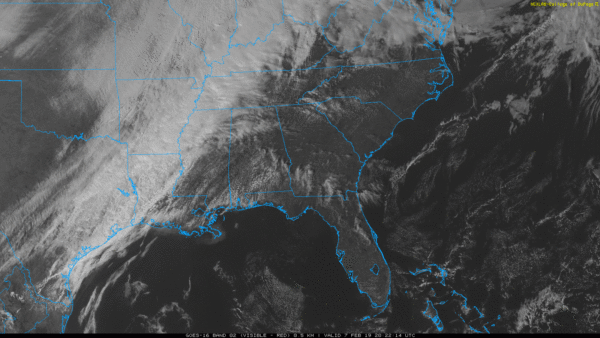
A cold front will pass through tonight, putting an end to the spring-like warmth. A few showers will accompany the front, but rain amounts will be fairly light, and there is no risk of severe thunderstorms. Tomorrow will be partly sunny, windy, and much colder with a high in the 47-50 degree range. A north wind of 12-22 mph will make it feel colder.
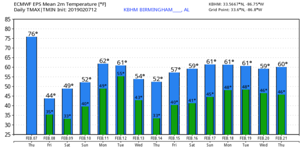
THE ALABAMA WEEKEND: Saturday morning will feature a freeze; with a clear and and light wind we start the day in the mid 20s. Then, the high Saturday afternoon will be in the mid 50s with a partly sunny sky. Clouds will increase Sunday, but most of the day will be dry with just a few isolated showers by mid to late afternoon over the northern counties of the state. Sunday’s high will be in the 57-60 degree range, very close to seasonal averages for mid-February.
NEXT WEEK: Monday will be a mostly cloudy and mild with with a few showers possible over the northern quarter of the state; the afernoon high will be in the mid to upper 60s. Then, on Tuesday, showers and a few thunderstorms are likely ahead of an approaching cold front. The latest global models suggest severe storms should not be an issue… then cooler, drier air follows on Wednesday with a partly sunny sky along with a high in the 50s. Thursday and Friday look cool and dry. See the Weather Xtreme video for maps, graphics, and more details.
ON THIS DATE IN 1835: A great freeze took place from February 2-9 across southern Georgia, southeastern South Carolina, and northern Florida. During this freeze, the St. Johns River was frozen, “several rods from the shore,” and people were able to walk a distance from the shore. Many citruses and other fruit trees were killed to the ground, never to grow again, when temperatures reached as low as 1ºF in Charleston and 8ºF in Jacksonville. A Florida gentleman told a newspaper that the state, “appeared as desolate as if a fire had swept over it,” after the severe freeze of that winter season.
BEACH FORECAST: Click here to see the AlabamaWx Beach Forecast Center page.
WEATHER BRAINS: Don’t forget you can listen to our weekly 90 minute show anytime on your favorite podcast app. This is the show all about weather featuring many familiar voices, including our meteorologists here at ABC 33/40.
CONNECT: You can find me on all of the major social networks…
Facebook
Twitter
Instagram
Pinterest
Snapchat: spannwx
I enjoyed seeing the kindergarten students today at White Plains Elementary School… be looking for them on the Pepsi KIDCAM today at 5:00 on ABC 33/40 News! The next Weather Xtreme video will be posted here by 7:00 a.m. tomorrow…
Category: Alabama's Weather, ALL POSTS, Weather Xtreme Videos
About the Author (Author Profile)
James Spann is one of the most recognized and trusted television meteorologists in the industry. He holds the AMS CCM designation and television seals from the AMS and NWA. He is a past winner of the Broadcast Meteorologist of the Year from both professional organizations.Subscribe
If you enjoyed this article, subscribe to receive more just like it.


