

Scattered Showers Today; Flooding Possible Next Week
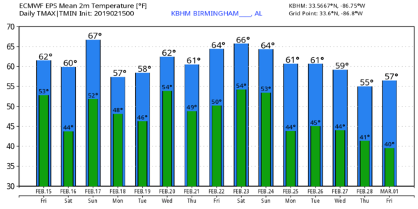
A FEW SHOWERS TODAY: A surface front will approach Alabama from the north today, meaning a mostly cloudy sky along with the risk of scattered showers as moisture levels rise. Showers will become more numerous tonight as the front eases southward through the northern counties of the state. Look for a high in the 60s this afternoon… the average high at Birmingham on February 15 is 58.
THE ALABAMA WEEKEND: That front will push into South Alabama tomorrow; it looks like a dry and cooler day for the northern half of the state. Some sun is possible during the afternoon and the high will be in the mid to upper 50s. Showers tomorrow should be confined to areas along and south of U.S. 84 (far South Alabama).
The front moves northward as a warm front Sunday, so showers are possible pretty much statewide. But, it won’t rain all day, and temperatures will be pleasant as afternoon temperatures rise into the mid to upper 60s.
FOOTBALL WEATHER: The weather will be cool and dry for tomorrow’s Birmingham Iron vs Salt Lake City Stallions game at Legion Field (1:00p CT kickoff). The sky will be generally cloudy, although some sun is possible at times. Temperatures will be in the upper 50s during the game.
NEXT WEEK: While a shower or two is possible Monday, we will focus on a multiple day, excessive rain event for the state Tuesday through Friday. The combination of high precipitable water, a stalled surface boundary, and a rather robust sub-tropical jet stream will bring rain, heavy at times, on these four days. Rain amounts of 4 to 8 inches are expected across the northern part of the state (I-20 and points north), with much lighter amounts for the southern part of the state.
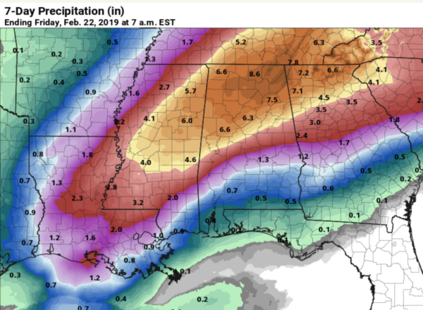
Flash flooding is a real possibility, along with longer term river flooding. If you live in a flood prone area, keep up with weather forecasts in coming days. A few thunderstorms are possible next week as well, but for now the severe weather threat looks low. The weather will be mild with highs on most days in the 60s… see the Weather Xtreme video for maps, graphics, and more details.
SEVERE WEATHER AWARENESS WEEK IN ALABAMA IS NEXT WEEK: This week promotes the importance of reviewing all information concerning severe weather and its associated preparedness. The primary spring severe weather season here is March, April, and May. There were 46 tornadoes documented in Alabama last year. The 30 year tornado average (1989-2018) is 47. The record number of tornadoes in a year was back in the 2011, when 145 tornadoes touched down. This extreme number was due to tornado outbreaks on April 15th and on April 27th.
BEACH FORECAST: Click here to see the AlabamaWx Beach Forecast Center page.
WEATHER BRAINS: Don’t forget you can listen to our weekly 90 minute show anytime on your favorite podcast app. This is the show all about weather featuring many familiar voices, including our meteorologists here at ABC 33/40.
CONNECT: You can find me on all of the major social networks…
Facebook
Twitter
Instagram
Pinterest
Snapchat: spannwx
I will be speaking this morning at the Alabama Association of Judicial Assistants conference in Birmingham this morning… look for the next Weather Xtreme video here by 4:00 this afternoon. Enjoy the day!
Category: Alabama's Weather, ALL POSTS, Weather Xtreme Videos
About the Author (Author Profile)
James Spann is one of the most recognized and trusted television meteorologists in the industry. He holds the AMS CCM designation and television seals from the AMS and NWA. He is a past winner of the Broadcast Meteorologist of the Year from both professional organizations.Subscribe
If you enjoyed this article, subscribe to receive more just like it.


