

Sunday Morning Quick Update on the Alabama Weather Situation
Lots to talk about in the video this morning, so expect it around 7:45 a.m.
But a quick update as of 7 a.m. to start your day:
A few light showers are falling across North Alabama this morning. Temperatures up north are near 50Fs. Across the I-20 Corridor, they are in the 50s, having risen during the night as our winds became southerly. A warm front is over South Central Alabama. It will come north during the day, producing showers.
Most folks will see around one quarter to one inch of rain by tonight, but some areas from Walker and Cullman Counties up into Northeast Alabama will see an inch or more.
High temperatures will range from 60 at Cullman and 57 at Fort Payne to 66F at Birmingham and 68F at Tuscaloosa. Places like Alex City will reach 73.
Along and north of I-20, don’t expect much in the way of sunshine today, but to the south, sunny skies will push the mercury to near 80F at Montgomery.
Monday will see cool conditions with some sunshine.
Tuesday will feature a long, steady, cold rain with highs in the 40s for most, 50s over West Alabama.
Wednesday will feature the heaviest rain and some storms. Flooding could become a problem. More rain and storms and the possibility of isolated severe weather for Thursday, Friday and Saturday. Highs will be in the upper 60s and lower 70s.
The rain will finally end by Sunday.
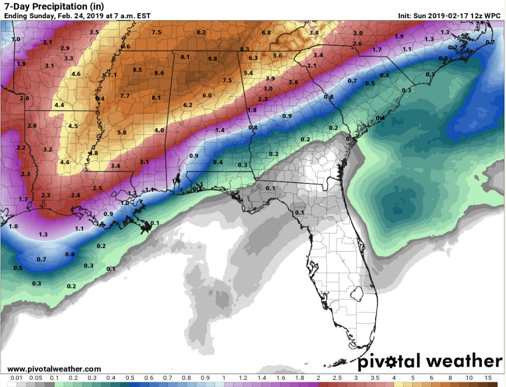
Here are 7-day rainfall totals through next Sunday:
Category: Alabama's Weather, ALL POSTS
About the Author (Author Profile)
Bill Murray is the President of The Weather Factory. He is the site's official weather historian and a weekend forecaster. He also anchors the site's severe weather coverage. Bill Murray is the proud holder of National Weather Association Digital Seal #0001 @wxhistorianSubscribe
If you enjoyed this article, subscribe to receive more just like it.


