

More Rain/Strong Storms Today
UNSETTLED WEATHER CONTINUES: Today will be another windy, wet, stormy day for Alabama, but at least temperatures will be considerably warmer for the northern counties of the state as a warm front moves north of us. A tight pressure gradient will keep winds (away from thunderstorms) out of the southeast in the 15-25 mph range, with higher gusts.
A band of showers and storms over Mississippi will move into the state this morning, and continue into the afternoon hours. Rain could be heavy at times, and a few strong storms are possible. In fact, SPC has defined a “marginal risk” (level 1/5) of severe thunderstorms for parts of West Alabama, generally west of a line from Tuscaloosa to Marion to Camden to Jackson.
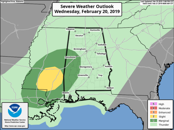
Some of the storms in the risk area could produce hail and strong gusty winds. There is even a low end tornado threat; we will watch radar trends closely. The high today will be in the 60s for most of the state; 70s are possible over Southwest Alabama. Those of you in Northeast Alabama, however, could remain in colder air with high in the 50s there.
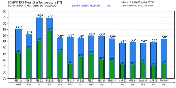
TOMORROW/FRIDAY: Occasional showers and thunderstorms remain likely as the unsettled pattern continues. There will be breaks in the rain, and we don’t expect any severe storms on these two days, but keep the rain gear handy. Tomorrow will be slightly cooler with a high between 57 and 61, then we will be warmer Friday with a high around 70 degrees.
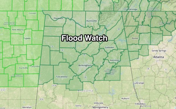
A flood watch remains in effect for the northern half of Alabama; additional rain amounts over the next few days will be in the 2 to 3 inch range. Many communities have already received three inches of rain since Sunday, and the ground is saturated.
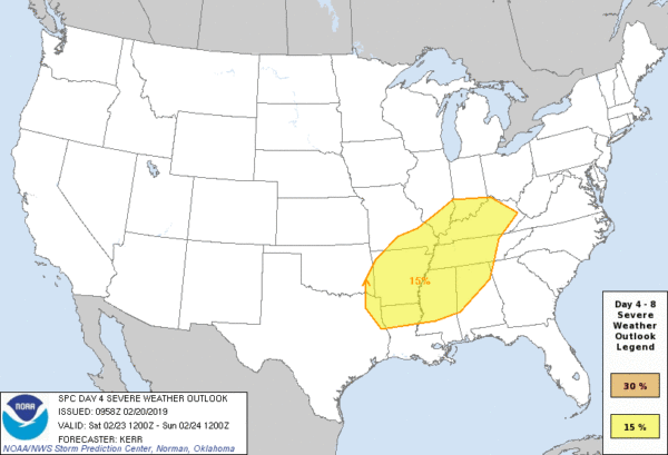
SEVERE STORMS POSSIBLE OVER THE WEEKEND: Saturday will be warm and windy with temperatures rising into the 70s. A few showers are possible during the morning, but an approaching cold front will push a band of strong to severe storms into the state later in the day and Saturday night. SPC has defined a severe weather risk for about the northern half of Alabama on their “Day 4” outlook.
The main window for severe storms will come from about 3:00 until 12:00 midnight Saturday; the main threat will come from damaging straight line winds, but an isolated tornado or two can’t be ruled out.
Drier air finally returns to the state Sunday… the sky becomes mostly sunny with a high in the 60s.
NEXT WEEK: Monday will be another day, pleasant day, but moist air returns Tuesday and Wednesday with a chance of showers. For now it doesn’t look like the rain will be too heavy… see the Weather Xtreme video for maps, graphics, and more details.
ON THIS DATE IN 1912: An F3 tornado killed nine people and injured 50 others as it crossed Centenary College in Shreveport, Louisiana. Centenary College would be hit again in 1940.
BEACH FORECAST: Click here to see the AlabamaWx Beach Forecast Center page.
WEATHER BRAINS: Don’t forget you can listen to our weekly 90 minute show anytime on your favorite podcast app. This is the show all about weather featuring many familiar voices, including our meteorologists here at ABC 33/40.
CONNECT: You can find me on all of the major social networks…
Facebook
Twitter
Instagram
Pinterest
Snapchat: spannwx
I have a weather program this morning at Mount Olive Elementary… be looking for the next Weather Xtreme video here by 4:00 this afternoon. Enjoy the day!
Category: Alabama's Weather, ALL POSTS, Weather Xtreme Videos
About the Author (Author Profile)
James Spann is one of the most recognized and trusted television meteorologists in the industry. He holds the AMS CCM designation and television seals from the AMS and NWA. He is a past winner of the Broadcast Meteorologist of the Year from both professional organizations.Subscribe
If you enjoyed this article, subscribe to receive more just like it.


