

Dry West Of I-59, Storms To The East
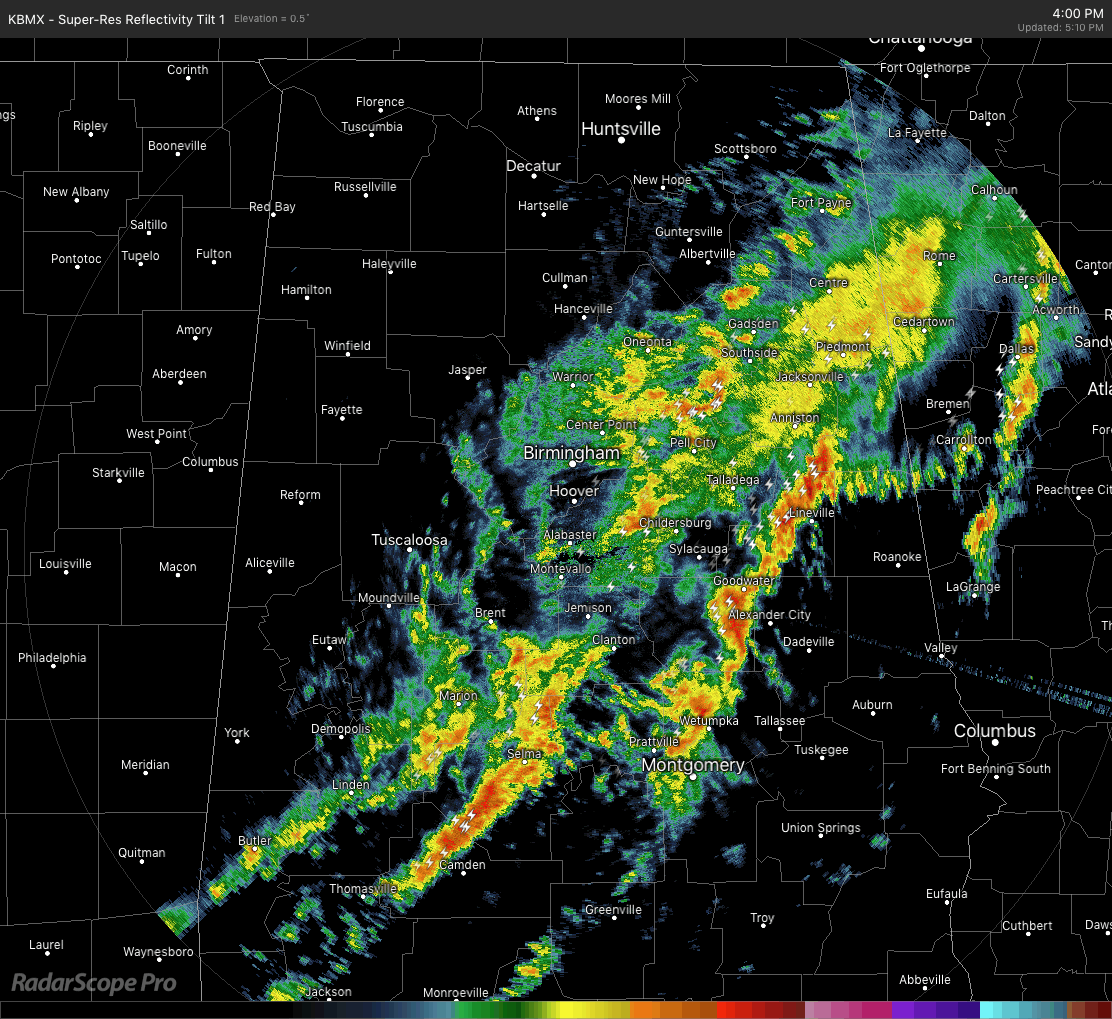
While the heavier showers and storms have now moved out of the areas stricken with flooding rains earlier today, unfortunately, those flood issues will continue for a little while longer. The line has now shifted east of the I-59 corridor across Central Alabama while much improved and drier conditions are west of I-59. Some of the storms in the line are producing some small hail and gusty winds at times, but no severe thunderstorm or tornado warnings have been issued so far.
The line of storms has now pushed east of the Marginal Risk for severe weather locations so it looks like the main threat for severe weather has now come to an end. I wouldn’t be surprised that a few of these cells may become stronger and warrant a significant weather advisory during the rest of the daylight hours.
The line of storms, as a whole, continues to move slowly to the east while the individual cells within the line move very rapidly to the northeast at around 50-60 MPH.
Temperatures across Central Alabama were mainly in the mid-50s to the mid-60s from north to south. Gadsden is the only station that is below that at 50 degrees, while a few locations in the south are tied at 66 degrees as the warm spots.
The line of storms will actually start to pivot into more of a horizontal orientation during the late night and overnight hours and start to move back to the north along with the warm front during the day on Friday. Rain will be likely along and just behind the front as it moves northward, then more scattered convective activity will start forming and moving across the area throughout the afternoon and early evening hours.
At this point, there is not a defined risk of severe storms anywhere in Central Alabama on Thursday, but a few strong storms are possible over the southeastern parts of the area south of the warm front. The main risks with the stronger storms will be from gusty winds and small hail.
Category: Alabama's Weather, ALL POSTS, Severe Weather
About the Author (Author Profile)
Scott Martin is an operational meteorologist, professional graphic artist, musician, husband, and father. Not only is Scott a member of the National Weather Association, but he is also the Central Alabama Chapter of the NWA president. Scott is also the co-founder of Racecast Weather, which provides forecasts for many racing series across the USA. He also supplies forecasts for the BassMaster Elite Series events including the BassMaster Classic.Subscribe
If you enjoyed this article, subscribe to receive more just like it.


