

Sub-Freezing Nights Ahead
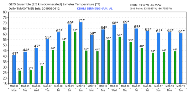
COLD: The sky has become partly sunny over Alabama this afternoon, with temperatures only in the 30s and 40s over the northern half of the state. In fact, Cullman is still below freezing (31 degrees) at 3:00 p.m. CT. The average high for March 4 (at Birmingham) is 63.
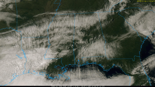
Freezing temperatures are ahead tonight; most places will drop into the 18-24 degree range over North/Central Alabama. Some clouds over the southern part of the state will keep temperatures a little warmer; in fact a few sprinkles, or even a few sleet patches or flurries are possible late tonight over parts of Southeast Alabama. No impact if any precipitation develops.
Tomorrow and Wednesday will be cold and dry with a good supply of sunshine both days. Highs will be in the 44-49 degree range, and another freeze is likely Wednesday morning with lows once again between 18 and 24 for most places. The low Thursday morning will be in the mid 20s, then a warming trend begins Thursday afternoon with ample sunshine along with a high in the low 60s.
FRIDAY AND THE WEEKEND: Moisture levels rise Friday and we will mention a chance of showers. Then, over the weekend, a complex storm system will bring more unsettled, stormy weather to Alabama. For now it looks like the main round of storms will come late Saturday into Saturday night, and the system certainly supports strong to severe storms, based on current model output. This event is still five days away, so things could change… just too early to be specific for now. We will keep an eye on it. Saturday will be very mild with a high in the 70s.
Showers should end early Sunday, followed by gradual clearing along with a high in the 60s.
NEXT WEEK: The first half of the week looks dry, but showers and storms will most likely return late Wednesday or Thursday… see the Weather Xtreme video for maps, graphics, and more details.
TORNADO SURVEYS: Preliminary EF-4 Tornado Damage has been found by NWS survey teams along Lee County Road 39 just east ofCave Mill Road near Beauregard. Winds have been estimated at 170 mph. Single family homes were completely destroyed. The death toll in this tornado remains at 23, but some are still missing and search and rescue operations continue.
An EF-1 tornado has been identified northwest of Eufaula; survey operations are still ongoing.
BEACH FORECAST: Click here to see the AlabamaWx Beach Forecast Center page.
WEATHER BRAINS: Don’t forget you can listen to our weekly 90 minute show anytime on your favorite podcast app. This is the show all about weather featuring many familiar voices, including our meteorologists here at ABC 33/40.
CONNECT: You can find me on all of the major social networks…
Facebook
Twitter
Instagram
Pinterest
Snapchat: spannwx
I had a great time today visiting with the first graders at Elvin Hill Elementary in Columbiana… be looking for them on the Pepsi KIDCAM today at 5:00 on ABC 33/40 News! The next Weather Xtreme video will be posted here by 7:00 a.m. tomorrow…
Category: Alabama's Weather, ALL POSTS, Weather Xtreme Videos
About the Author (Author Profile)
James Spann is one of the most recognized and trusted television meteorologists in the industry. He holds the AMS CCM designation and television seals from the AMS and NWA. He is a past winner of the Broadcast Meteorologist of the Year from both professional organizations.Subscribe
If you enjoyed this article, subscribe to receive more just like it.


