

Dry Tomorrow/Wednesday; Rain Returns Thursday
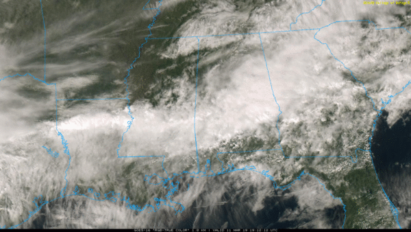
RADAR CHECK: A large mass of rain covers much of Central Alabama this afternoon; this is in response to a wave of low pressure moving along a stalled front over the southern part of the state. There is a big thermal contrast on either side of the front; temperatures are in the 50s across North Alabama, but to the south Mobile reports 81 degrees at 2:00p CDT. Rain will end from west to east this evening, and we drop into the 40s overnight.
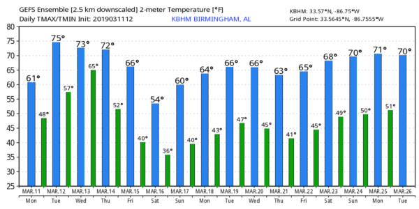
TOMORROW/WEDNESDAY: These two days will be dry for most of the state; with a mix of sun and clouds we project a high in the low 70s tomorrow, followed by mid 70s Wednesday. Some South Alabama communities could rise to near 80 degrees again. It will feel like spring. Clouds increase Wednesday night as moisture levels begin to rise.
THURSDAY/FRIDAY: A very deep surface low will set up across the Great Plains Wednesday, moving toward the Great Lakes by Thursday night. The trailing cold front will bring a band of rain and thunderstorms in to Alabama Thursday. With the main upper support well to the north, the chance of severe storms looks low at this point, although a strong storm is certainly possible. The weather will stay mild with a high in the 70s. Then, on Friday, rain ends very early in the day, and the sky becomes partly sunny as dry air returns. Friday will be cooler with a high in the 60-65 degree range.
THE ALABAMA WEEKEND: Look for dry and cool weather across the state Saturday and Sunday. Morning lows will drop into the mid 30s with potential for some frost; colder pockets across North and Central Alabama could see a freeze. The high Saturday will be in the mid to upper 50s, followed by mid 60s Sunday. Mostly sunny days, fair nights.
NEXT WEEK: For now the weather actually looks fairly dry much of the week with seasonal temperatures… See the Weather Xtreme video for maps, graphics, and more details.
ON THIS DATE IN 1888: The Great Blizzard of 1888 paralyzed the east coast from the Chesapeake Bay to Maine on March 11 through the 14th. The blizzard dumped as much as 55 inches of snow in some areas, and snow drifts of 30 to 40 feet were reported. An estimated 400 people died from this blizzard.
WEATHER RADIO PROGRAMMING IN JACKSONVILLE: We will be in Jacksonville next Monday night, March 18, programing weather radios. Bring your weather radio and we will check it for you; we will be on the 5th floor of JSU Stadium from 4:00 until 6:30 p.m. I will be there doing weather live on ABC 33/40.
BEACH FORECAST: Click here to see the AlabamaWx Beach Forecast Center page.
WEATHER BRAINS: Don’t forget you can listen to our weekly 90 minute show anytime on your favorite podcast app. This is the show all about weather featuring many familiar voices, including our meteorologists here at ABC 33/40.
CONNECT: You can find me on all of the major social networks…
Facebook
Twitter
Instagram
Pinterest
Snapchat: spannwx
I enjoyed seeing the students this morning at Primrose School at Riverwoods in Helena… be looking for them on the Pepsi KIDCAM on ABC 33/40 News today at 5:00! The next Weather Xtreme video will be posted here by 7:00 a.m. tomorrow…
Category: Alabama's Weather, ALL POSTS, Weather Xtreme Videos
About the Author (Author Profile)
James Spann is one of the most recognized and trusted television meteorologists in the industry. He holds the AMS CCM designation and television seals from the AMS and NWA. He is a past winner of the Broadcast Meteorologist of the Year from both professional organizations.Subscribe
If you enjoyed this article, subscribe to receive more just like it.


