

Showers & Sunshine Out There At Midday
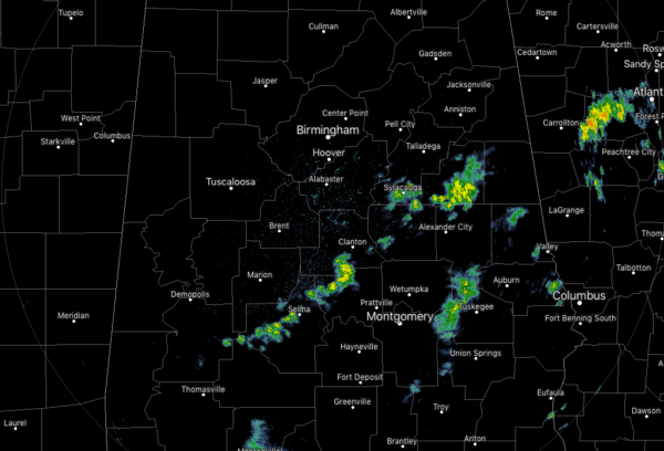
At 11:15 am, we continue to have some scattered showers across the southern half of the area while the northern half is dry. The shower activity is light to moderate but shouldn’t last too long in any one spot as they are moving to the northeast at just short of 50 MPH. No lightning with these as well, but I wouldn’t be surprised if one or two of these have some lightning involved this afternoon before they move out of the state later today.
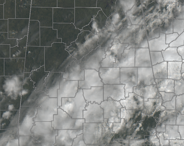
Clouds are starting to clear out of the northwestern parts of the area, while there still remains a good bit over the southern 2/3rds of the area. While most of these clouds will push eastward throughout the day, we may have more move in later tonight just for a little while. Temperatures are currently in the lower 50s to the mid-60s across the area and should top out in the upper 50s to the lower 70s from northwest to southeast for our daytime highs.
For tonight, we’ll have partly to mostly cloudy skies across the area and there still may be a few scattered showers across the extreme southern locations in Central Alabama, but chances for any showers down there will be really small. Overnight lows fall down into the mid-30s to the upper 40s across the area.
The forecast becomes rather easy for a good while as we are expected to see plenty of sunshine and no rain, at least through next Friday. Saturday will feature nearly maximum sunshine with just a few clouds floating overhead with highs reaching the upper 50s to the lower 60s across the area. Saturday night will remain mostly clear with lows dipping down into the lower 30s to the lower 40s.
SURVEYS TODAY ON POSSIBLE TORNADO DAMAGE FROM THURSDAY’S SEVERE STORMS
NWS Birmingham has three main target areas planned for today in Central Alabama: Blount, Elmore, and Chilton counties. If time allows, they will survey damage in other areas not targeted for today. Possible tornado damage has been reported in 10 Central Alabama counties total, including Marengo, Perry, Dallas, Bibb, Chilton, Coosa, Autauga, Elmore, St. Clair, and Blount counties. NWS Huntsville will be conducting surveys on damage reported in Lawrence and Cullman counties.
BEACH FORECAST CENTER
Get the latest weather and rip current forecasts for the beaches from Fort Morgan to Panama City on our Beach Forecast Center page. There, you can select the forecast of the region that you are interested in.
ALREADY OFF TO A HOT START IN 2019! ADVERTISE WITH THE BLOG!
We have enjoyed over 5.3 MILLION page views on AlabamaWx.com so far in 2019! Don’t miss out! We can customize a creative, flexible and affordable package that will suit your organization’s needs. Contact Bill Murray at (205) 687-0782.
E-FORECAST
Get the Alabama Wx Weather Blog’s Seven-Day Forecast delivered directly to your inbox by email twice daily. It is the most detailed weather forecast available in Central Alabama. Subscribe here… It’s free!
CONNECT WITH THE BLOG ON SOCIAL MEDIA
You can find the AlabamaWx Weather Blog on the major social media networks:
Facebook
Twitter
Category: Alabama's Weather, ALL POSTS
About the Author (Author Profile)
Scott Martin is an operational meteorologist, professional graphic artist, musician, husband, and father. Not only is Scott a member of the National Weather Association, but he is also the Central Alabama Chapter of the NWA president. Scott is also the co-founder of Racecast Weather, which provides forecasts for many racing series across the USA. He also supplies forecasts for the BassMaster Elite Series events including the BassMaster Classic.Subscribe
If you enjoyed this article, subscribe to receive more just like it.


