

A Severe Thunderstorm Warning Remains In Effect Until 6:15 PM CDT For Northern Elmore And Southeastern Coosa Counties

…A SEVERE THUNDERSTORM WARNING REMAINS IN EFFECT UNTIL 615 PM CDT FOR NORTHERN ELMORE AND SOUTHEASTERN COOSA COUNTIES… At 549 PM CDT, a severe thunderstorm was located near Dexter, or near Equality, moving east at 40 mph.
HAZARD…70 mph wind gusts and ping pong ball size hail.
SOURCE…Radar indicated.
IMPACT…People and animals outdoors will be injured. Expect hail damage to roofs, siding, windows, and vehicles. Expect considerable tree damage. Wind damage is also likely to mobile homes, roofs, and outbuildings. Locations impacted include… Equality, Eclectic, Speed, Pentonville, Santuck, Weoka Mills, Ten Cedar Estates, Kowaliga Bridge, Dexter, Western Lake Martin, Jordan Lake, Southern Lake Martin, Claud and Central.
A Severe Thunderstorm Warning Remains In Effect Until 6:15 PM CDT For Northern Elmore And Southern Coosa Counties
Mar 25th @ 5:30 pm

…A SEVERE THUNDERSTORM WARNING REMAINS IN EFFECT UNTIL 615 PM CDT FOR NORTHERN ELMORE AND SOUTHERN COOSA COUNTIES… At 530 PM CDT, a severe thunderstorm was located over Welona, or 13 miles southwest of Rockford, moving east at 45 mph.
HAZARD…70 mph wind gusts and ping pong ball size hail.
SOURCE…Radar indicated.
IMPACT…People and animals outdoors will be injured. Expect hail damage to roofs, siding, windows, and vehicles. Expect considerable tree damage. Wind damage is also likely to mobile homes, roofs, and outbuildings. Locations impacted include… Equality, Eclectic, Speed, Pentonville, Santuck, Titus, Weoka Mills, Jordan Lake, Welona, Ten Cedar Estates, Kowaliga Bridge, Higgins Ferry Park, Dexter, Western Lake Martin, Mitchell Lake, Southern Lake Martin, Claud, Central and Mitchell Dam.
Severe Thunderstorm Warning Issued For Parts Of Coosa And Elmore Counties Until 6:15PM
Mar 25th @ 5:22 pm
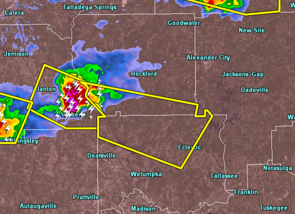

The National Weather Service in Birmingham has issued a
* Severe Thunderstorm Warning for…
Northern Elmore County in east central Alabama…
Southern Coosa County in east central Alabama…
* Until 615 PM CDT.
* At 522 PM CDT, a severe thunderstorm was located over Verbena, or 10 miles southeast of Clanton, moving east at 45 mph.
HAZARD…60 mph wind gusts and quarter size hail.
SOURCE…Radar indicated.
IMPACT…Hail damage to vehicles is expected. Expect wind damage to roofs, siding, and trees.
* Locations impacted include…
Equality, Eclectic, Speed, Pentonville, Santuck, Titus, Weoka
Mills, Jordan Lake, Welona, Ten Cedar Estates, Kowaliga Bridge, Higgins Ferry Park, Dexter, Western Lake Martin, Mitchell Lake, Southern Lake Martin, Claud, Central and Mitchell Dam.
Category: ALL POSTS
About the Author (Author Profile)
Subscribe
If you enjoyed this article, subscribe to receive more just like it.


