

Severe Threat Over For Most, Continues In The South
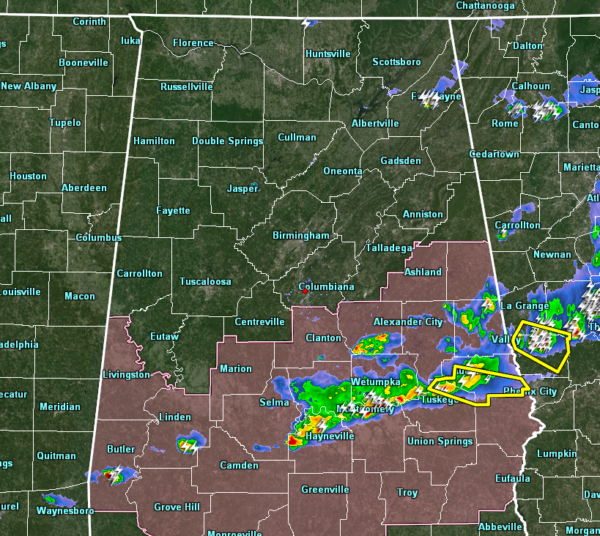
As of 6:52 pm, the severe storm threat continues for the extreme southern and southeastern parts of Central Alabama. At this point, the severe storm threat has ended for locations north of a line from Linden Clanton to Wedowee.
There is only one severe thunderstorm warning in the area at this point and it is for the location who doesn’t need to see any more severe weather. Parts of Lee and Macon counties are under a severe thunderstorm warning until 7:30 pm. This particular cell has a history of producing some damage in Chilton and Elmore counties, including structural damage in Downtown Clanton. If you are in or near the tornado damaged location, please seek shelter immediately.
The threat of severe storms should continue for at least the next hour or two then everyone will be clear from the threat. Counties to the north of the broken line of supercells will continue to be canceled as the threat comes to an end.
Here is another damage Tweet in from Clanton:
View of the Clanton storm damage from above… from William Scarbrough pic.twitter.com/T3P9FsGGgv
— James Spann (@spann) March 25, 2019
Category: Alabama's Weather, ALL POSTS, Severe Weather
About the Author (Author Profile)
Scott Martin is an operational meteorologist, professional graphic artist, musician, husband, and father. Not only is Scott a member of the National Weather Association, but he is also the Central Alabama Chapter of the NWA president. Scott is also the co-founder of Racecast Weather, which provides forecasts for many racing series across the USA. He also supplies forecasts for the BassMaster Elite Series events including the BassMaster Classic.Subscribe
If you enjoyed this article, subscribe to receive more just like it.


