


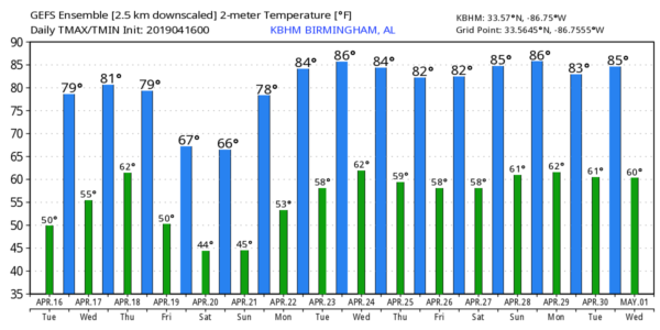
ANOTHER BEAUTIFUL SPRING DAY: With a clear sky, temperatures are mostly in the 40s across Alabama early this morning. We are forecasting sunshine in fully supply today with a high between 77 and 80 degrees for most communities. Tomorrow will be mostly sunny and warm with a high in the low 80s. And, while we enjoy the dry, warm weather, severe storms will likely break out west of here as another dynamic storm system moves out of the western U.S. There is a risk of severe storms tomorrow afternoon and tomorrow night in a broad zone from Texas to the Midwest.
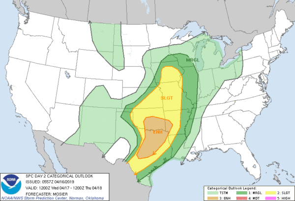
THURSDAY/THURSDAY NIGHT: Thursday will be a warm, windy day for Alabama with increasing clouds and a high around 80 degrees. Showers and storms will move into the state late in the day and Thursday night, and SPC has all of Alabama in the standard “slight risk” (level 2/5) of severe thunderstorms.
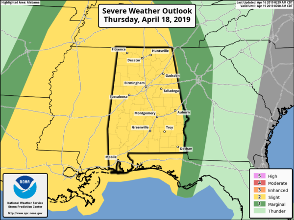
Models continue to slow the system down, and we now believe the main risk of strong to severe thunderstorms will come from 4:00 p.m. Thursday until 4:00 a.m. Friday. Storms could produce hail and gusty winds… and a tornado threat is possible as well. But, models are showing very limited instability over the northern half of the state Thursday night, which could limit the overall severe weather threat north of U.S. 80. A case of very good dynamics, but weak thermodynamics.
But it will be another night to be weather aware, and to have a way of hearing warnings if they are needed. Remember, this is April in Alabama, the core of our spring tornado season, and events like this are very common.
FRIDAY: A deep, cold core upper low will pass right over Alabama on Friday. This will set the stage for a cloudy, very cool day with periods of rain. Some of the showers might even produce a little small hail because of the very cold air aloft associated with the upper low. We won’t get out of the 50s.
EASTER WEEKEND: The upper system will lift away from the state, and the weekend will be dry with a warming trend. Expect lots of sunshine both days; the high Saturday will be in the 67-70 degree range, followed by upper 70s Sunday.
NEXT WEEK: The first half of the week will be warm and dry with highs in the 80s; some risk of showers and storms will return by Thursday or Friday. See the Weather Xtreme video for maps, graphics, and more details.
ON THIS DATE IN 1851: “The Lighthouse Storm” of 1851 struck New England on this date. Heavy gales and high seas pounded the coasts of New Hampshire and eastern Massachusetts. The storm arrived at the time of a full moon, and high tide was producing unusually high storm tides. The storm was so named because it destroyed the lighthouse at Cohasset, Massachusetts. Two assistant lighthouse keepers were killed there when the structure was swept away by the storm tide.
BEACH FORECAST: Click here to see the AlabamaWx Beach Forecast Center page.
WEATHER BRAINS: Don’t forget you can listen to our weekly 90 minute show anytime on your favorite podcast app. This is the show all about weather featuring many familiar voices, including our meteorologists here at ABC 33/40.
CONNECT: You can find me on all of the major social networks…
Facebook
Twitter
Instagram
Pinterest
Snapchat: spannwx
I have weather programs today at Gardendale’s First Baptist Church, and at Margaret Elementary in St. Clair County… look for the next Weather Xtreme video here by 4:00 this afternoon. Enjoy the day!


