


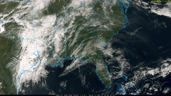
ACTIVE SPRING WEATHER: High cirrus clouds are over Alabama this afternoon; nothing on radar and temperatures are mostly in the mid to upper 70s. We note a showers and storms over Northeast Mississippi; some of those could clip the northwest corner of our state tonight, but most places will stay dry overnight.
Tomorrow will be mild, and strong south winds will develop by afternoon, averaging 15-25 mph with higher gusts.
SEVERE WEATHER THREAT: A robust spring system will bring the threat of severe storms to Alabama tomorrow night. The Storm Prediction Center has defined an “enhanced risk” (level 3/5) for areas west of a line from Cullman to Birmingham to Montgomery to Geneva, and a “slight risk (level 2/5) covers the rest of the state.
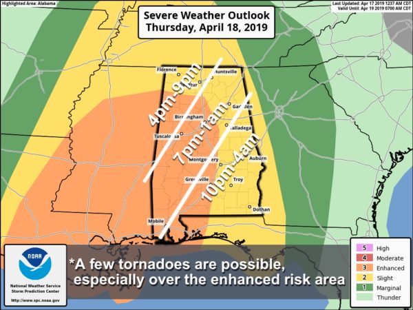
TIMING: A few storms could reach far West Alabama as early as 4:00, but the main threat comes tomorrow night. Thunderstorms will push out of the region after midnight.
THREATS: Storms tomorrow night are capable of producing damaging wind and a few tornadoes. Some hail is possible, but that threat is lower. Highest tornado risk is in the “enhanced” risk, where the best combination of shear and instability will be found. But, understand a tornado or two can’t be ruled out in the “slight risk” area as well.
RAIN: Rain amounts of around 1 inch are expected, and no flooding issues are anticipated.
Be sure you and your family can hear severe weather warnings tomorrow night if needed; NEVER rely on a siren. Have WEA (Wireless Emergency Alerts) enabled on your smart phone (check it under notification settings). In your safe place, have helmets for everyone. And, if you live in a mobile/manufactured home, know the location of the nearest shelter or open business (like a truck stop, restaurant, gas station, etc), and be ready to get out in a hurry if tornado warnings begin.
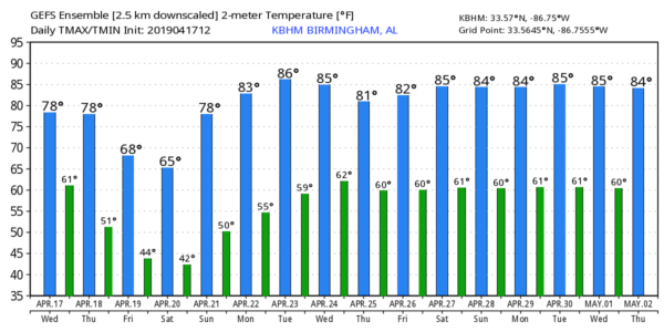
FRIDAY: The severe weather threat moves on to the east; Friday in Alabama will be cloudy and much cooler as a deep, cold core upper low passes overhead. Temperatures will be in the 50s all day, and there will be periods of rain. Some small hail is possible with showers due to the cold air aloft associated with the upper low.
EASTER WEEKEND: Any lingering clouds over East Alabama will dissipate by mid-morning Saturday, otherwise the weekend will feature a sun-filled sky both days. Early morning lows will be in the 40s… the high Saturday will be in the 65-70 degree range, followed by mid to upper 70s Sunday.
NEXT WEEK: Dry, warm weather is forecast Monday through Wednesday… then showers and storms return Thursday, possibly into Friday. The following weekend (April 27-28) looks dry and pleasant for now. See the Weather Xtreme video for maps, graphics, and more details.
ON THIS DATE IN 1979: Most major rivers in Alabama were way out of their banks. Record or near record crests occurred along much of the Tombigbee, Black Warrior and Sucarnoochee Rivers with severe residential and commercial flooding in areas such as Tuscaloosa, Demopolis, Gainesville and Livingston. Thousands of acres of farm lands, woodlands, and pasture lands were flooded, as well as numerous camps and cabins along these rivers. When all the floodwaters had receded, damage was estimated at $75 million with at least 15 deaths in the state.
BEACH FORECAST: Click here to see the AlabamaWx Beach Forecast Center page.
WEATHER BRAINS: Don’t forget you can listen to our weekly 90 minute show anytime on your favorite podcast app. This is the show all about weather featuring many familiar voices, including our meteorologists here at ABC 33/40.
CONNECT: You can find me on all of the major social networks…
Facebook
Twitter
Instagram
Pinterest
Snapchat: spannwx
I enjoyed seeing the second graders today at Floyd Elementary in Gadsden… be looking for them on the Pepsi KIDCAM today at 5:00 on ABC 33/40 News! The next Weather Xtreme video will be posted here by 7:00 a.m. tomorrow…


