

Weather Xtreme: Stubborn Showers Today, Beautiful Easter Sunday
The cold core low is still just off to our north over the southeastern parts of Kentucky, leaving us with a chance of scattered showers continuing to wrap-around into the northeastern quarter of the state. Those should be out of here by the early afternoon hours. Skies will be in a slow clearing process, but by sunset, much of Central Alabama will have clear to mostly clear skies. Afternoon highs across the area will top out in the upper 50s to the upper 60s from northeast to southwest. Winds will be breezy at times out of the northwest at 10-20 MPH with gusts up to 30 MPH possible.
It will be a totally different story for Easter Sunday. It will be a cold start for those attending sunrise services, with early morning lows starting off in the lower to mid-40s. There will be plenty of sunshine throughout the day and clear skies during the night. Afternoon highs will be back up in the mid to upper 70s with overnight lows in the upper 40s to the lower 50s.
Monday will be another brilliant day across Central Alabama with plenty of sun and very little in the way of clouds. Afternoon highs return to the upper 70s to the lower 80s across the area.
A disturbance starts to build well off to our west on Tuesday that will send some clouds in our direction that leaves us with a mix of sun and clouds. We’ll continue to stay dry and highs will be in the upper 70s to the lower 80s.
That disturbance slowly gets closer to the area on Wednesday, but we’ll once again be dry with a mix of sun and clouds. Highs will be in the upper 70s to the mid-80s.
On Thursday, a trough will be centered just off to our west over the eastern parts of Texas… close enough to have a chance of showers and thunderstorms invade Central Alabama. At this point, it doesn’t look to be a severe weather setup, but we’ll keep an eye on it. Highs will be in the mid-70s to the lower 80s.
On Friday, shower chances come to an end early in the day, leaving us with clearing skies during the afternoon and evening hours. Highs will be in the mid-70s to the lower 80s.
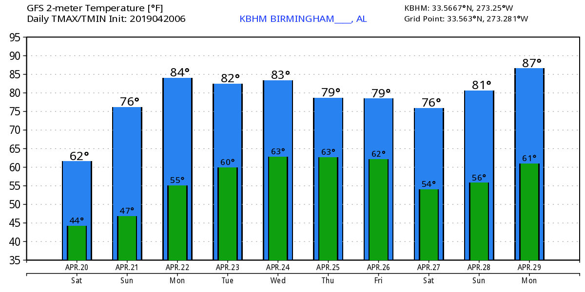
Taking a brief look into Voodoo Land for next weekend looks like there will be plenty of sunshine on both days as any rain will stay off to our north. The GFS is painting highs in the 70s and 80s with lows in the 50s.
BEACH FORECAST CENTER
Get the latest weather and rip current forecasts for the beaches from Fort Morgan to Panama City on our Beach Forecast Center page. There, you can select the forecast of the region that you are interested in.
ALREADY OFF TO A HOT START IN 2019! ADVERTISE WITH THE BLOG!
We have enjoyed over 8.4 MILLION page views on AlabamaWx.com so far in 2019! Don’t miss out! We can customize a creative, flexible and affordable package that will suit your organization’s needs. Contact Bill Murray at (205) 687-0782.
E-FORECAST
Get the Alabama Wx Weather Blog’s Seven-Day Forecast delivered directly to your inbox by email twice daily. It is the most detailed weather forecast available in Central Alabama. Subscribe here… It’s free!
CONNECT WITH THE BLOG ON SOCIAL MEDIA
You can find the AlabamaWx Weather Blog on the major social media networks:
Facebook
Twitter
Instagram
WEATHERBRAINS
Don’t forget you can listen to our weekly 90 minute netcast anytime on the web at WeatherBrains.com or on iTunes, Stitcher, or Spotify. This is the show all about weather featuring many familiar voices, including the meteorologists at ABC 33/40.
Category: Alabama's Weather, ALL POSTS, Weather Xtreme Videos
About the Author (Author Profile)
Scott Martin is an operational meteorologist, professional graphic artist, musician, husband, and father. Not only is Scott a member of the National Weather Association, but he is also the Central Alabama Chapter of the NWA president. Scott is also the co-founder of Racecast Weather, which provides forecasts for many racing series across the USA. He also supplies forecasts for the BassMaster Elite Series events including the BassMaster Classic.Subscribe
If you enjoyed this article, subscribe to receive more just like it.


