


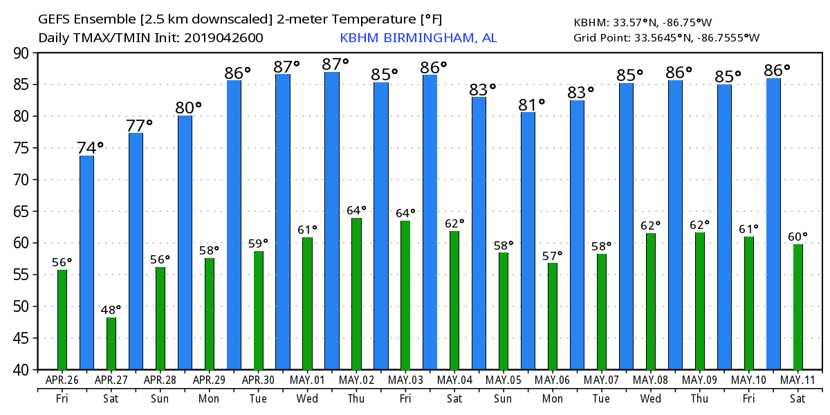
WINDY DAY: Strong northwest winds will develop across Alabama today due to a tight pressure gradient; they will average 15-25 mph this afternoon with higher gusts. Those winds will pull in drier into the state, and the sky will become sunny today… the high will be in the 72-75 degree range. The average high for April 26 at Birmingham is 77.
Tonight will clear and cool, and the winds will diminish. Most communities will drop into the upper 40s early tomorrow morning… it will be one of the last times we see lows in the 40s this season.
THE ALABAMA WEEKEND: Tomorrow will be a sunny day with a high between 77 and 80 degrees. Then, on Sunday, the sky will be partly sunny with a high back in the upper 70s. A weak surface front will drift into Alabama during the day, and we will bring in a small risk of a shower over the northern half of the state. But, odds of any one spot getting wet are only around 10 percent due to limited moisture.
RACE WEEKEND AT TALLADEGA: The sky will clear today with gusty northwest winds; tomorrow will be sunny. The high today will be in the low 70s, followed by upper 70s tomorrow. Sunday will partly sunny, and there is a small chance of a shower during the GEICO 500. The actual chance of a shower is only 10 percent, and the high Sunday will be close to 78 degrees.
NEXT WEEK: A strong upper ridge will bring very warm and dry weather to the state for most of the week. Afternoon highs will be generally in the mid 80s, but upper 80s are very possible by mid-week. A few showers are possible over the Tennessee Valley region of North Alabama Thursday and Friday, but most of the state will be dry. Showers are more likely by Friday night and Saturday (May 3-4) as the ridge breaks down… See the Weather Xtreme video for maps, graphics, and more details.
ON THIS DATE IN 2011: The second day of the great tornado outbreak of April 2011 was underway. A total of 55 tornadoes were confirmed the 26th, although no fatalities occurred. Numerous tornadoes touched down across several states, including Texas, Louisiana, Arkansas. Most of those tornadoes were weak, but a few of them caused considerable damage. A long-tracked wedge tornado caused EF2 damage in rural portions of Texas and Louisiana. An EF3 tornado destroyed structures and caused severe damage at Fort Campbell, Kentucky as well. Alabama’s turn would come the following day, April 27.
BEACH FORECAST: Click here to see the AlabamaWx Beach Forecast Center page.
WEATHER BRAINS: Don’t forget you can listen to our weekly 90 minute show anytime on your favorite podcast app. This is the show all about weather featuring many familiar voices, including our meteorologists here at ABC 33/40.
CONNECT: You can find me on all of the major social networks…
Facebook
Twitter
Instagram
Pinterest
Snapchat: spannwx
I will be speaking in Oxford this morning, and I have program for home school students early this afternoon in Hoover. Then, I will be live on ABC 33/40 from the Magnolia Festival in Gardendale… no afternoon Weather Xtreme video today, but I will post new forecast notes here this afternoon. Enjoy the day!


