

Unsettled Weather Through The Weekend
HEAVIER STORMS SHIFTING INTO SOUTH ALABAMA: The line of storms over Northwest Alabama this morning just didn’t want to go away. In fact, the storms intensified as they moved eastward, producing scattered tree and power line damage in a number of counties. As of 3:00, the heavier storms have shifted down into the southern half of Alabama.
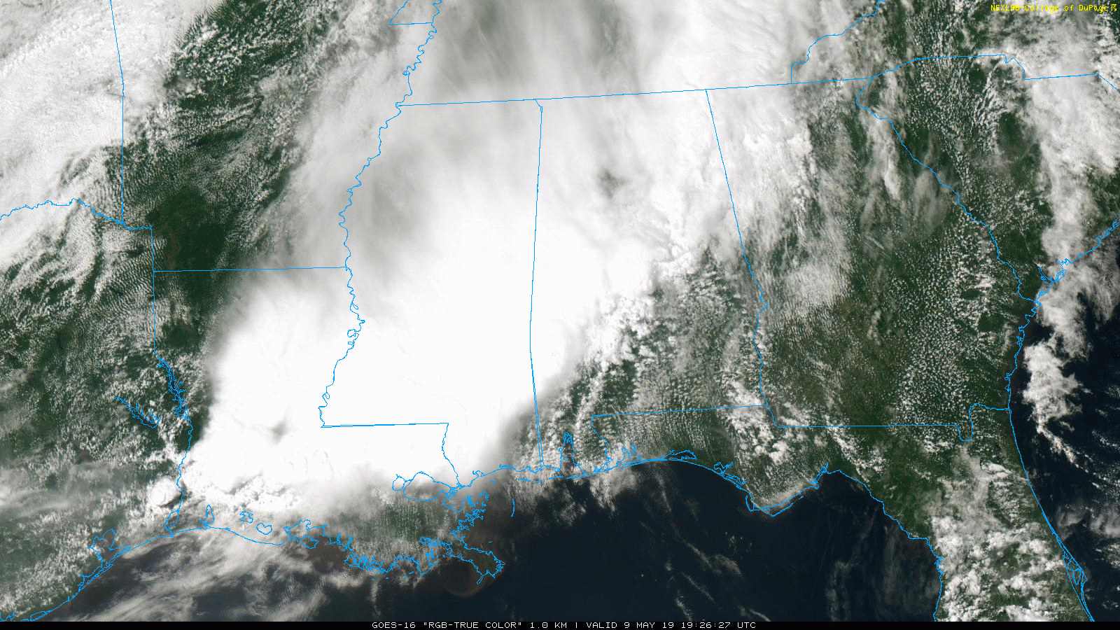
The air over the northern counties of the state is cool and stable after the morning rain, and additional severe storms are not expected tonight… just some lingering light to moderate rain.
TOMORROW AND THE WEEKEND: A stalled surface front will sit across Alabama, meaning we will have to deal with occasional showers and thunderstorms tomorrow, Saturday, and Sunday. High resolution models have been performing very poorly, but the large scale setup favors unsettled weather. Here are some notes on the weather situation on these three days…
*It is impossible to give specific rain start/stop times for any specific location. Just be ready for an occasional passing shower or thunderstorm.
*Showers are possible at any hour of the day or night, but they should be most numerous during the afternoon and evening hours.
*Of the three days, the most widespread rain will most likely come on Sunday. Even then there will be some good breaks in the wet weather.
*A few strong storms are possible; SPC has the northern two-thirds of the state in a “marginal risk” (level 1/5) Saturday. I think the chance of a few severe storms is actually a bit higher on Sunday when some dynamic forcing comes into play, and wind fields are more robust.
*Remember, when you hear thunder, get indoors. Even if it is not raining.
*Rain amounts between now and Sunday night will be in the 1-2 inch range for the northern half of Alabama.
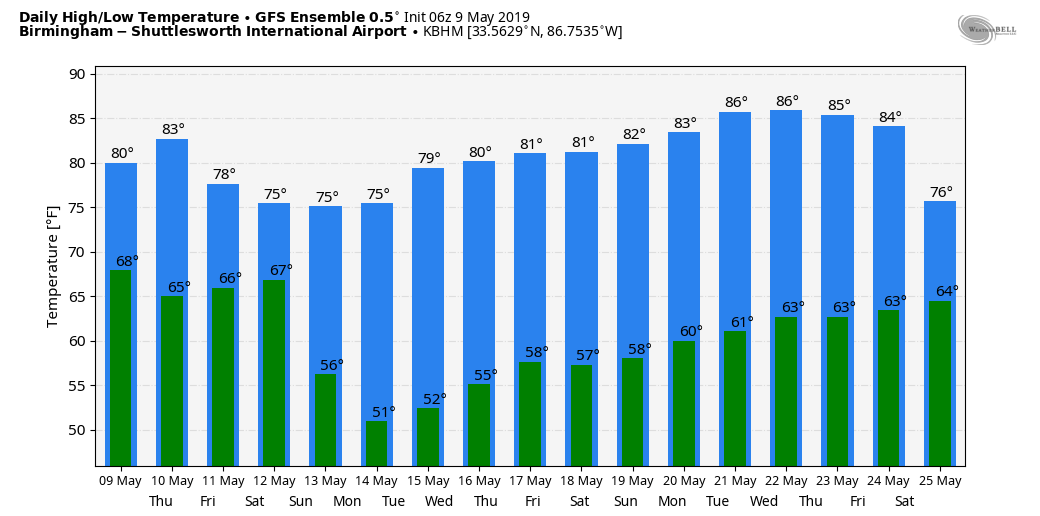
*Look for a high in the low 80s tomorrow, and between 77 and 81 degrees Saturday and Sunday.
NEXT WEEK: Models continue to trend drier; the wave at mid-week will most likely impact the Gulf of Mexico, and for now the week looks dry with partly to mostly sunny days and fair nights. Highs will be in the 78-82 degree range Monday through Wednesday, and in the mid 80s Thursday and Friday. See the Weather Xtreme video for maps, graphics, and more details.
ON THIS DATE IN 1995: An F3 tornado produced $10 million in damages along its 40-mile path across central Illinois. The tornado caused significant damage in Cantrall where three homes were destroyed, 10 had significant damage, and 11 had minor damage. The roof and interior of a grade school suffered extensive damage. The tornado passed about 2 miles southeast of the new NWS Office in Lincoln, Illinois.
REGIONS TRADITION: The Regions Tradition is underway at the beautiful Greystone Golf & Country Club! Make plans to attend one of the majors of the PGA Champions Tour! You can see legendary golfers Miguel Ángel Jiménez, Fred Couples, John Daly, Vijay Singh, and more tee it off with Nick Saban, Gus Malzahn, Bo Jackson, Condoleezza Rice, and other celebrities in the NCR Pro-AM. Juniors 18 & under are admitted free with a ticketed adult, and five-day grounds tickets are $100. Single day grounds tickets are $25. GET YOUR TICKETS HERE!!!
BEACH FORECAST: Click here to see the AlabamaWx Beach Forecast Center page.
WEATHER BRAINS: Don’t forget you can listen to our weekly 90 minute show anytime on your favorite podcast app. This is the show all about weather featuring many familiar voices, including our meteorologists here at ABC 33/40.
CONNECT: You can find me on all of the major social networks…
Facebook
Twitter
Instagram
Pinterest
Snapchat: spannwx
Look for the next Weather Xtreme video here by 7:00 a.m. tomorrow…
Category: Alabama's Weather, ALL POSTS, Weather Xtreme Videos
About the Author (Author Profile)
James Spann is one of the most recognized and trusted television meteorologists in the industry. He holds the AMS CCM designation and television seals from the AMS and NWA. He is a past winner of the Broadcast Meteorologist of the Year from both professional organizations.Subscribe
If you enjoyed this article, subscribe to receive more just like it.


