

Severe T-Storm Warning For Jefferson, St. Clair, Talladega Counties Until 5:30 PM

BULLETIN – IMMEDIATE BROADCAST REQUESTED
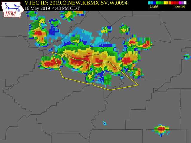
Severe Thunderstorm Warning
National Weather Service Birmingham AL
442 PM CDT Thu May 16 2019
The National Weather Service in Birmingham has issued a
* Severe Thunderstorm Warning for…
North central Talladega County in east central Alabama…
Northeastern Jefferson County in central Alabama…
Southwestern St. Clair County in central Alabama…
* Until 530 PM CDT.
* At 442 PM CDT, severe thunderstorms were located along a line
extending from 6 miles northeast of Odenville to near Argo to near
Warrior, moving southeast at 20 mph.
HAZARD…60 mph wind gusts and quarter size hail.
SOURCE…Radar indicated.
IMPACT…Hail damage to vehicles is expected. Expect wind damage
to roofs, siding, and trees.
* Locations impacted include…
Northeastern Birmingham, Trussville, Gardendale, Pell City, Leeds,
Moody, Fultondale, Springville, Odenville, Center Point, Clay,
Pinson, Tarrant, Lincoln, Margaret, Argo, Warrior, Kimberly, Morris
and Chalkville.
PRECAUTIONARY/PREPAREDNESS ACTIONS…
For your protection move to an interior room on the lowest floor of a
building.
Large hail and damaging winds and continuous cloud to ground
lightning is occurring with these storms. Move indoors immediately.
Lightning is one of nature’s leading killers. Remember, if you can
hear thunder, you are close enough to be struck by lightning.
Category: Alabama's Weather, ALL POSTS, Severe Weather
About the Author (Author Profile)
Scott Martin is an operational meteorologist, professional graphic artist, musician, husband, and father. Not only is Scott a member of the National Weather Association, but he is also the Central Alabama Chapter of the NWA president. Scott is also the co-founder of Racecast Weather, which provides forecasts for many racing series across the USA. He also supplies forecasts for the BassMaster Elite Series events including the BassMaster Classic.Subscribe
If you enjoyed this article, subscribe to receive more just like it.


