

The Heat Is On
Pools, lakes, the beach: those are the places to be on this Memorial Day weekend, as Alabama and the Southeast continues to be stuck in an early season heat wave.
SATURDAY HIGHS: Yesterday was a hot one across our state and the Southeast. Highs across Alabama included 94F at Birmingham, 95F at Montgomery, 97F at Florence and Tuscaloosa, 99F at Dothan, and a hot 100F at Andalusia. Readings early this morning are in the middle and upper 60s to near 70F.
ANOTHER HOT ONE: Highs today, under mostly sunny skies, will once top out again in the 90s across the area, with no cooling relief in sight in the form of a shower, or even much in the way of clouds. We are calling for 93F at Anniston, 95F at Birmingham and 96F at Tuscaloosa. Stay cool, everyone.
NO RELIEF UNTIL THURSDAY: Highs Monday, Tuesday and Wednesday will once again be in the 93-97F range across Central Alabama, with hardly any chance of rain. Lows will be near 70F, and dewpoints will be consistently in the middle 60s, making it feel quite uncomfortable.
PATTERN SHIFT: We finally see a bit of a pattern shift by late in the week, as the stubborn subtropical high that has been centered over the Southeast finally breaks down a bit and the deep trough out west shifts eastward. This results in a fairly flat upper-level pattern over the Deep South. By Thursday, Alabama should be in a deep southerly flow off the Gulf of Mexico, and a few scattered showers and storms could return to the landscape. During the day on Thursday, surface low pressure will be moving into the Upper Midwest, dragging a front through the Mid-South. This will mean a round of showers and storms for the state.
WEEKEND SHOWERS: It looks like a few showers will continue through the weekend, and into the first part of the following week before we dry out again. We return to fairly typical summertime temperature readings, with highs around 90F. Lows will be in the 60s next weekend, with lower humidity, but we quickly will return to the monotonous lows around 70F by the following week.
DON’T GET YOUR HOPES UP: In the rainfall department at least. Rainfall distribution may be quite varied with this setup. Some places will see less than a half inch, while a few luck communities may see over an inch. This means our recent overall dryness trend will continue.
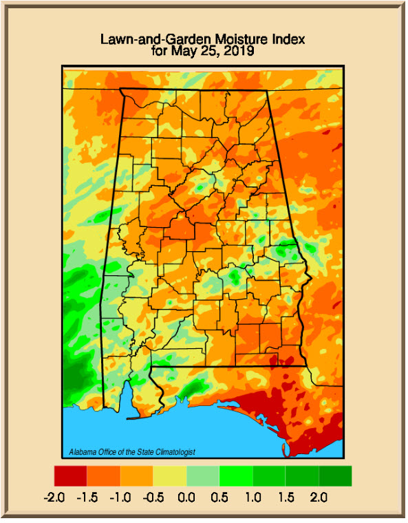
DROUGHTWATCH: Dr. John Christy’s Lawn and Garden Moisture Index for Alabama shows more of the haves and mostly have-nots across the area, with areas needing moisture.
VOODOO TERRITORY: By Thursday the 7th, we will be watching to see if a surface low can develop and move through the Ohio Valley. This will spell increased rain chances again for Alabama. Keep your fingers crossed.
TROPICS: The tropical Atlantic is quiet and no development is expected over the next two weeks, although we will have to watch an increase in convective activity moving across the Caribbean toward the Gulf of Mexico by late in the period, around June 11th.
ON THIS DATE IN 1924: On the 26th and 27th, an outbreak of tornadoes in the Deep South killed 53. An entire family of 8 was killed near Elkmont, Alabama.
Category: Alabama's Weather, ALL POSTS
About the Author (Author Profile)
Bill Murray is the President of The Weather Factory. He is the site's official weather historian and a weekend forecaster. He also anchors the site's severe weather coverage. Bill Murray is the proud holder of National Weather Association Digital Seal #0001 @wxhistorianSubscribe
If you enjoyed this article, subscribe to receive more just like it.


