

Still Hot; Mostly Dry For Memorial Day
DON’T FORGET: Memorial Day is set aside as a day for remembering and honoring those who have died while serving in the United States Armed Forces. A price has been paid for our freedom… never forget those sacrifices.
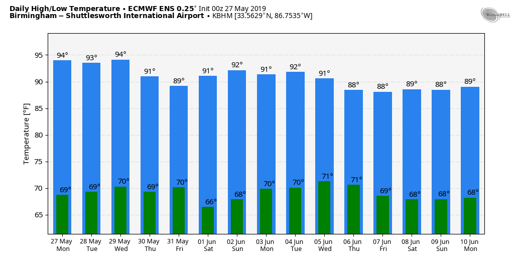
HIGHS STAY IN THE 90s: Not much change in the Alabama weather situation today; mostly sunny and hot with a high in the mid to upper 90s for most places, right at record levels for late May. A few tiny, isolated showers could pop up during the heat of the afternoon, but odds of any one spot getting wet are less than 10 percent. Birmingham’s record high for today (May 27) is 98, set in 1962. The average high today is 84.
REST OF THE WEEK: The strong upper high will keep the state hot and dry tomorrow through Thursday with mostly sunny days and fair nights. Highs will be generally in the mid 90s. But, on Friday, the upper high weakens a bit, and a weak surface boundary drifts into the state. This should trigger a few widely scattered, mostly afternoon and evening showers and thunderstorms. Nothing really widespread, but at least a few places could see a cooling shower. The high on Friday will drop back into the 88-92 degree range.
THE ALABAMA WEEKEND: We are looking at fairly routine early June weather this weekend. Partly sunny days with “widely scattered, mostly afternoon and evening showers and thunderstorms”. Chance of any one spot getting wet both days is about one in four, and the high will be between 88 and 92.
NEXT WEEK: The core of the upper high should be a little west of Alabama, so we will roll with a persistence forecast. A few widely scattered storms around during the heat of the day with highs not far from 90 degrees. See the Weather Xtreme video for maps, graphics, and more details.
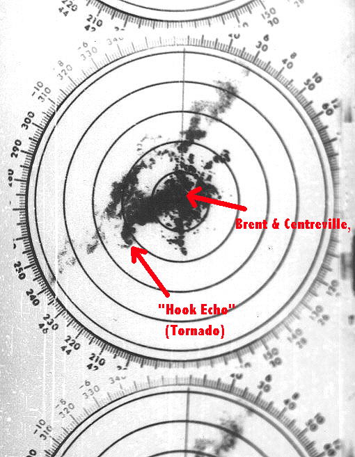
ON THIS DATE IN 1973: A long track EF-4 tornado touched down northeast of Demopolis and traveled northeastward. A great amount of damage occurred in the locations of Greensboro, Brent, Centreville, Montevallo, Columbiana, Wilsonville, Childersburg, and many areas in between. The tornado finally lifted near Mt. Cheaha after creating a path of damage over 139 miles long and up to 800 yards wide at its largest. A total of six people were killed and another 128 were injured along the path, including the town of Brent where five lost their lives and 56 were injured when almost the complete town was destroyed. Another person died and 72 were injured in the town of Greensboro. A grand total of 216 buildings were destroyed, 570 buildings damaged, 97 mobile homes destroyed, and 45 businesses were either damaged or destroyed. Along with all of the structural damage, over 12,000 acres of timber was destroyed.
The NWS radar facility near Brent was heavily damaged by the tornado; the radar dish had been blown from its tower and lay on the ground about 20 feet from the office. The roof was two thirds gone, and the rest of the building looked as it had been sand blasted.
ALSO ON MAY 27, 1973: Another large tornado touched down northeast of Tarrant at approximately 5:50PM CDT and started on its path of causing great damage. The first major location it hit was Center Point, where most of the damage of the entire path occurred. 32 frame homes were destroyed, along with 48 mobile homes, and more than 300 homes sustained damage. One person lost his life as he and his family were taking shelter in their basement, and the home collapsed. The tornado continued northeast passing close to St. Clair Springs, just south of Springville, and just north of Ashville, before lifting near Gadsden. The total damage path was estimated at 50 miles, and was 800 yards wide and its widest. Wind speeds were estimated at 162-209 MPH.
BEACH FORECAST: Click here to see the AlabamaWx Beach Forecast Center page.
WEATHER BRAINS: Don’t forget you can listen to our weekly 90 minute show anytime on your favorite podcast app. This is the show all about weather featuring many familiar voices, including our meteorologists here at ABC 33/40.
CONNECT: You can find me on all of the major social networks…
Facebook
Twitter
Instagram
Pinterest
Snapchat: spannwx
We are on a holiday schedule, so just one Weather Xtreme video today, but I will post fresh forecast notes here later today. Enjoy the day!
Category: Alabama's Weather, ALL POSTS, Weather Xtreme Videos
About the Author (Author Profile)
James Spann is one of the most recognized and trusted television meteorologists in the industry. He holds the AMS CCM designation and television seals from the AMS and NWA. He is a past winner of the Broadcast Meteorologist of the Year from both professional organizations.Subscribe
If you enjoyed this article, subscribe to receive more just like it.


