

Classic Summer Weather Ahead
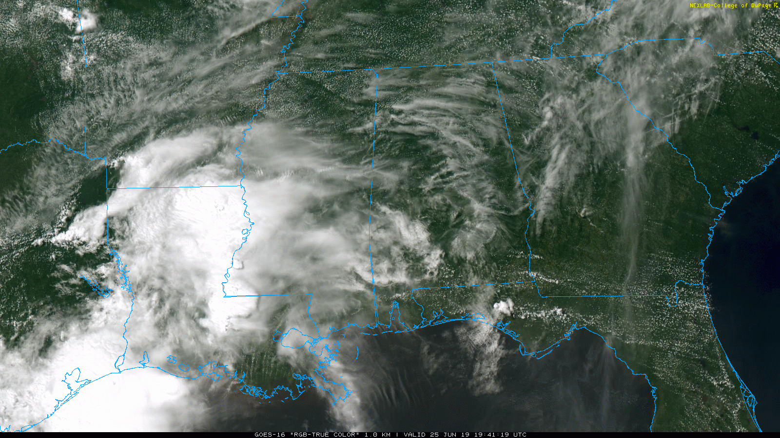
RADAR CHECK: No rain over most of Alabama this afternoon… about the only showers on radar are over northern Baldwin County at mid-afternoon, northeast of Mobile. Temperatures are mostly in the 87-90 degree range over the northern half of the state, but South Alabama is sizzling… we are seeing mid 90s at Mobile and Dothan. There is still a low end “marginal risk” of severe storms (level 1/5) for South Alabama through the evening hours… any storms that form there could be strong with gusty winds.
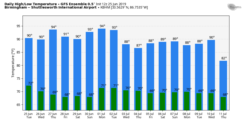
REST OF THE WEEK: We will lapse into a very typical summer weather pattern tomorrow through Friday. Partly sunny, hot, humid days with a few widely scattered showers or storms possible each afternoon… highs will be between 88 and 93 degrees.
THE ALABAMA WEEKEND: No reason to change the foreacst… classic late June weather. Partly sunny days, fair nights, and again the risk of random, scattered showers and thunderstorms generally between 2:00 and 10:00 p.m. No way of knowing in advance when and where they form… and highs will be between 89 and 93.
NEXT WEEK: Once again we will go with a persistence forecast. Hot and humid summer weather… partly sunny days, fair nights, and the risk of a passing shower or thunderstorm during the afternoon and evening hours. Highs mostly in the low 90s, lows mostly in the low 70s. Classic early July weather. See the Weather Xtreme video for maps, graphics, and more details.
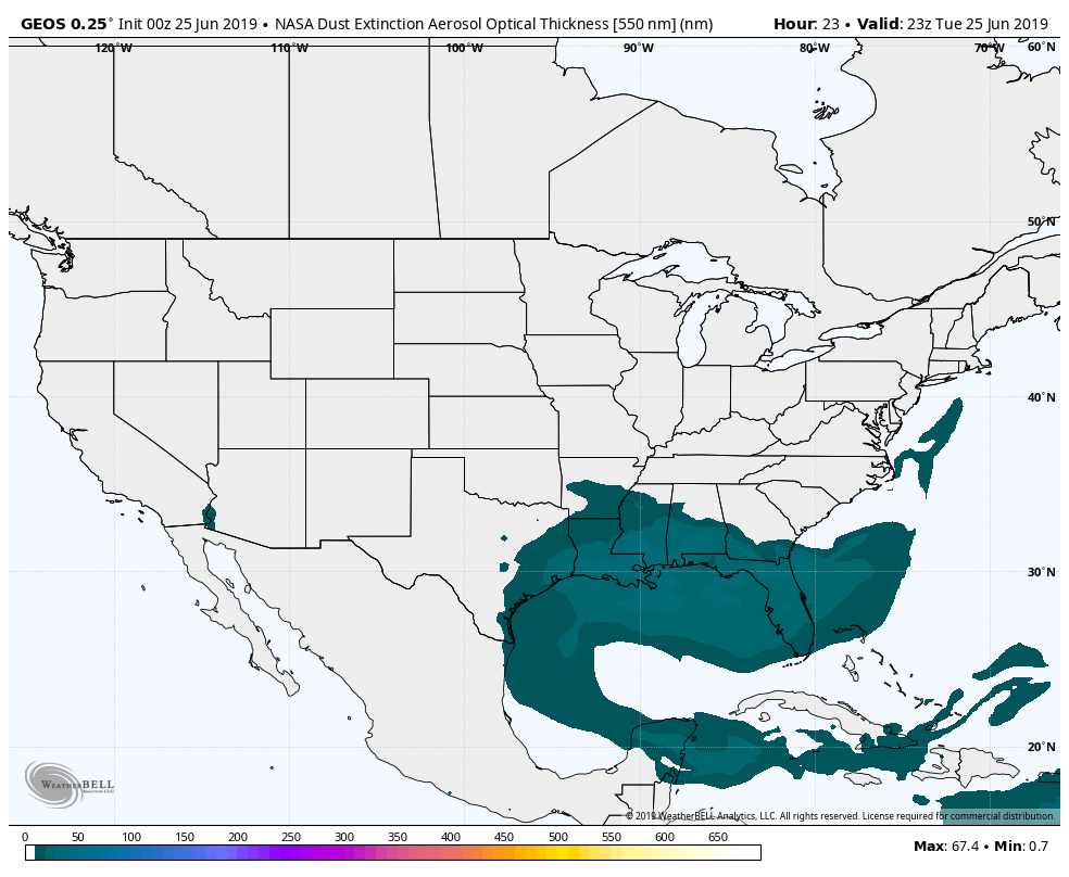
AFRICAN DUST: The Saharan Air Layer (SAL) persists over a decent part of Alabama today. I am afraid many don’t understand this; it isn’t especially common, but then again it isn’t too unusual. From time to time in summer dry, dusty air from the deserts of Africa are transported in high levels across the Atlantic and the Caribbean, curving up into the Gulf of Mexico. When the SAL creeps into the Deep South, most of the dust is between 5,000 and 20,000 feet, and the main effect is creating very vivid sky scenes at sunrise and sunset.
Some of the dust could filter down to the surface, and air quality today in the Birmingham is in the “yellow” zone due to particulates. But, understand we are in the yellow zone most summer days; air quality isn’t impacted much by the SAL, which is mostly well off the ground.
The SAL will gradually shift west of Alabama in coming days.
ON THIS DATE IN 1957: Hurricane Audrey moved northward, slowly strengthening until the 26th. At that time, a strong upper-level trough led to its acceleration and the hurricane deepened rapidly on its final approach to the Texas/Louisiana border. Audrey became the strongest hurricane on record for June upon landfall, as it reached category four strength. Its acceleration was unanticipated, and despite hurricane warnings in place, 418 people perished in the storm, mainly across southwest Louisiana.
BEACH FORECAST: Click here to see the AlabamaWx Beach Forecast Center page.
WEATHER BRAINS: Don’t forget you can listen to our weekly 90 minute show anytime on your favorite podcast app. This is the show all about weather featuring many familiar voices, including our meteorologists here at ABC 33/40.
CONNECT: You can find me on all of the major social networks…
Facebook
Twitter
Instagram
Pinterest
Snapchat: spannwx
I enjoyed seeing a big group today at the Double Springs Public Library… be looking for them on the Pepsi KIDCAM today at 5:00 on ABC 33/40 News! The next Weather Xtreme video will be posted here by 7:00 a.m. tomorrow…
Category: Alabama's Weather, ALL POSTS, Weather Xtreme Videos
About the Author (Author Profile)
James Spann is one of the most recognized and trusted television meteorologists in the industry. He holds the AMS CCM designation and television seals from the AMS and NWA. He is a past winner of the Broadcast Meteorologist of the Year from both professional organizations.Subscribe
If you enjoyed this article, subscribe to receive more just like it.


