A Rinse, Repeat Forecast for Central Alabama
A few light showers were on the radar early on the Sunday morning across Alabama. They have passed through the Tuscaloosa and Birmingham areas this morning, edging northward. Nothing to really to see, just a reminder of how juicy our atmosphere is this morning.
A SUMMER FOG: Dense fog is occurring this morning over the southeastern parts of Central Alabama, in places like Clanton, Alex City, Montgomery, Prattville, Wetumpka, Troy, and Eufaula. Visibilities may be reduced to less than 1/.4 and caution should be exercised if driving. The fog should burn off mostly by 9 a.m.
FOR THE REST OF YOUR SUNDAY: Today will be partly cloudy, hot and humid, with scattered showers and storms developing by late morning. Storms that get cranking will have the opportunity to become strong, with lots of dangerous lightning, gusty winds, and heavy rains. Highs today will top out in the upper 80s to lower 90s. Lows tonight will be in the lower 70s.
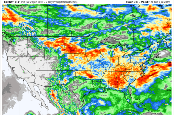
RINSE, REPEAT: It’s more of the same for Monday, Tuesday, Wednesday, and beyond. Highs will be gradually inching up into the middle 90s mostly by the middle of the week as high pressure builds over the area. Lows will be in the muggy lower and middle 70s.
FOURTH FORECAST: Independence Day will dawn muggy and warm across Alabama with morning lows in the middle 70s heading to afternoon highs in the lower 90s. Fairly typical summertime fare across Alabama. Scattered showers and storms will develop during the heating of the afternoon and dissipating during the evening. Area fireworks displays should be just fine.
TROPICS: The tropical Atlantic is quiet. No tropical cyclones are expected to form during the next ten days.
GULF COAST WEATHER: The week ahead will feature fairly typical but hotter than normal conditions along the beautiful beaches of Alabama and Northwest Florida. Expect 7-9 hours of sunshine each day, with about a 1 in 3 chance of a thunderstorm. Seas will be fairly flat, and there is little chance of undertows unless big storms affect the shoreline. Highs will be in the lower and middle 90s with a late morning and early afternoon seabreeze helping a bit. Lows will be in the middle and upper 70s. Water temperatures are running in the middle 80s. Click here to see the Beach Forecast Center page.
WEATHERBRAINS: This week, the panel will entertain Michael Eckert who is a NOAA meteorologist at the FAA Control Center in New York City. Check out the show at www.WeatherBrains.com. You can also subscribe on iTunes. You can watch the show live at live.bigbrainsmedia.com You will be able to see the show on the James Spann 24×7 weather channel on cable or directly over the air on the dot 2 feed.
ON THIS DATE IN 1944: F Control of the U.S. Weather Bureau was transferred from the Department of Agriculture to the Department of Commerce. The growth of the aviation industry is the reason for the change. One of the first projects undertaken by the reorganized Weather Bureau was to study how to improve weather forecasts for military installations, munitions plants, and transportation for the war effort. Munitions plants were of particular concern since lightning could trigger explosions that could kill and injure workers. Follow my weather history tweets on Twitter. I am @wxhistorian at Twitter.com.
Category: Alabama's Weather, ALL POSTS


