

Strong Storm Approaching Sumter County; Tropical Mischief Possible This Week in Gulf
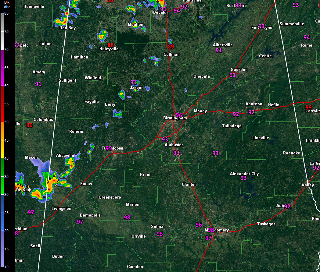
An upper-level disturbance pushing southeastward slowly across northern Mississippi has triggered a loosely organized group of storms that is pushing across western Alabama.
The storms are running into hostile conditions and aren’t amounting to much, except further to the southwest. Storms over Pickens County near Aliceville and are approaching northern Sumter County from DeKalb County, Mississippi. The storms have heavy rain, dangerous lightning, some very small hail and winds that could gust to 40 mph.
The storms will continue pushing southeastward for the next few hours. They are not expected to increase in coverage or intensity.
The story has been the heat. This hour, Birmingham is at 96F, Tuscaloosa at 95F, Anniston at 92F and Calera is at 93F. Heat index values are pushing 99-104F across Central Alabama. Evergreen has hit 101F and Greenville 100F in the temperature department. Mobile’s Brookley Field is at 97F with a dewpoint of 74F, pushing the heat index to 108F.
All week, we have been following the eventual disposition of this disturbance and the possibility that it could produce a surface low over the northeastern Gulf of Mexico by the middle of next week.
Water temperatures over the northeastern Gulf are warm, shear should be low, and we are in a favorable Madden-Julian Oscillation phase for development, so the possibility is there.
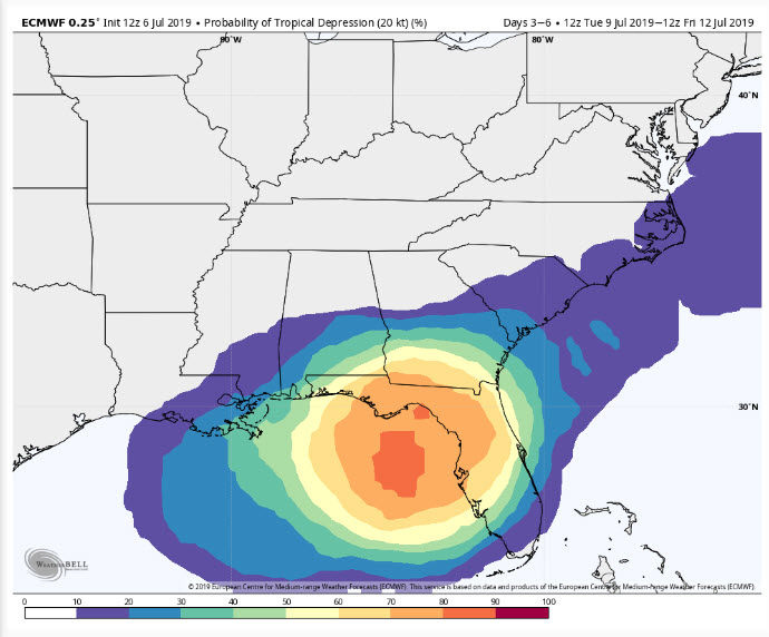
European model probability of a tropical depression forming by end of next week.
The European has been consistently pointing to this possibility and develops a surface low over the northeastern Gulf by Wednesday evening. The ensembles put the probability at over 80%. It depicts this low moving slowly westward to a point south of Pensacola by Friday morning and inland near Mobile as a weak tropical storm by Saturday morning. It then moves it into Central Alabama on Saturday. This could bring beneficial rains to parts of Alabama.
But there is lots of uncertainty in this scenario. The European has had it wast of Central Alabama, west of Central Alabama, and right up the middle of the state, so all options are on the table, including no development at all.
It the Mobile scenario does play out, it would bring adverse conditions to the Central Gulf Coast and the beautiful beaches of Alabama and Northwest Florida by midweek into the weekend. It could bring 2-4 inches of rain to areas west of I-65 and 0ver 4 inches for eastern sections of the state. Winds would be brisk, but not a problem for Central Alabama.
Category: Alabama's Weather, ALL POSTS
About the Author (Author Profile)
Bill Murray is the President of The Weather Factory. He is the site's official weather historian and a weekend forecaster. He also anchors the site's severe weather coverage. Bill Murray is the proud holder of National Weather Association Digital Seal #0001 @wxhistorianSubscribe
If you enjoyed this article, subscribe to receive more just like it.


