

Wet/Unsettled Weather Ahead Thanks To Barry
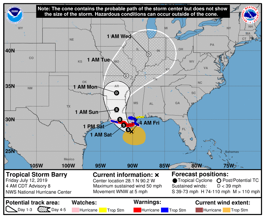
OCCASIONAL TROPICAL DOWNPOURS: Tropical Storm Barry, with sustained winds of 50 mph, should make landfall tonight on the Louisiana coast, followed by a slow northward motion through Louisiana and eastern Arkansas. Alabama will stay on the wet, east side of the system, and we will deal with occasional showers and tropical downpours through early next week.
Look for scattered to numerous showers and storms this afternoon and tonight; after midnight the heaviest rain will pull back toward the center of Barry to the southwest of Alabama. The sky will be cloudy at times, and the high today will be between 87 and 90 for most places.
TOMORROW THROUGH MONDAY: The sun could break out at times, but the sky will be generally cloudy tomorrow through Monday, with occasional showers and storms. They will be most numerous during the afternoon and evening hours, but in this pure, tropical airmass some rain could come at any hour of the day or night. Unfortunately there is no way of knowing specific start/stop times of the rain for any given point. The high tomorrow will be in the mid to upper 80s, and many communities will hold in the 70s all day Sunday because of clouds and rain.
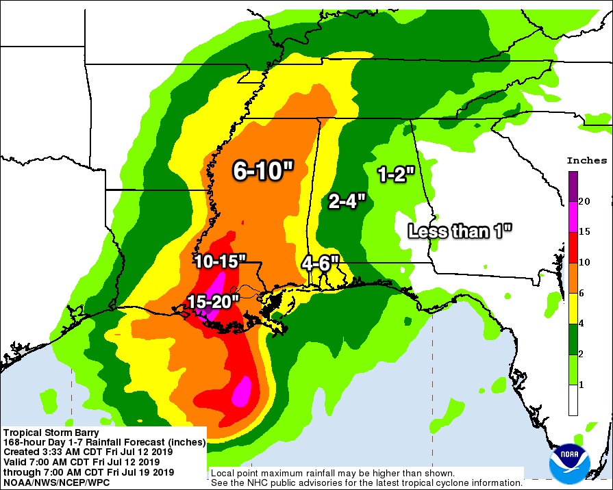
Heaviest rain should be on the western side of the state, where 4-6 inches are possible near the Mississippi border. Central Alabama can expect 2-4 inches of rain, and the eastern counties of the state will see 1-2 inches.
A low end tornado threat could develop tomorrow and Sunday over parts of far West and Southwest Alabama; we will need to watch radar trends closely for heavier cells around the Mississippi border. But, for most of Alabama, we don’t expect any severe weather over the weekend.
ON THE COAST: Double red flags will be flying from Fort Morgan to Panama City Beach today and through the weekend, meaning there are dangerous rip current and the water is closed. The beaches will be open. While the sun will be out at times, occasional showers are likely over the weekend. A flash flood watch remains in effect for Mobile, Baldwin, and Washington counties in Alabama, and for Escambia and Santa Rosa counties in Florida. A flash flood watch is also in effect for most of South Mississippi and Southeast Louisiana. Parts of Southeast Louisiana will see 10-20 inches of rain in association with Tropical Storm Barry, with a high risk of flooding.
The weather on the coast will improve next week with showers and storms becoming more scattered in nature, and seas will settle down as well.
TRAVEL: I am getting so many questions about driving conditions tomorrow and over the weekend across the Southeast U.S. I possess no special knowledge or skill about future road conditions. All depends on risk tolerance… and that is different for different people. Just pay attention to NWS watches and warnings and keep up with the latest weather information to help you make a good decision.
NEXT WEEK: Barry will pull very moist air into Alabama, and it will linger Monday and Tuesday with a good chance of occasional showers and storms both days. The weather slowly trends drier and hotter over the latter half of the week… See the Weather Xtreme video for maps, graphics, and more details.
ON THIS DATE IN 1996: Hurricane Bertha makes landfall near Wrightsville Beach, NC with maximum winds of 105 mph, but the storm surge dealt the most devastation. The U.S. Virgin Islands, along with North Carolina, were declared federal disaster areas. Surveys indicate that Bertha damaged almost 2,500 homes on St. Thomas and St. John. For many, it was the second hit in the ten months since Hurricane Marilyn devastated the same area. The primary effects in North Carolina were to the coastal counties and included storm surge flooding and beach erosion, roof damage, piers washed away, fallen trees and damage to crops. Over 5,000 homes were damaged, mostly from storm surge. Storm total rainfall amounts ranged from 5 to 8 inches along a coastal strip from South Carolina to Maine. Overall, as many as 12 deaths resulted with 8 in the U.S. and territories.
BEACH FORECAST: Click here to see the AlabamaWx Beach Forecast Center page.
WEATHER BRAINS: Don’t forget you can listen to our weekly 90 minute show anytime on your favorite podcast app. This is the show all about weather featuring many familiar voices, including our meteorologists here at ABC 33/40.
CONNECT: You can find me on all of the major social networks…
Facebook
Twitter
Instagram
Pinterest
Snapchat: spannwx
Look for the next Weather Xtreme video here by 4:00 this afternoon… enjoy the day!
Category: Alabama's Weather, ALL POSTS, Weather Xtreme Videos
About the Author (Author Profile)
James Spann is one of the most recognized and trusted television meteorologists in the industry. He holds the AMS CCM designation and television seals from the AMS and NWA. He is a past winner of the Broadcast Meteorologist of the Year from both professional organizations.Subscribe
If you enjoyed this article, subscribe to receive more just like it.


