

Late Morning Look at Barry’s Impacts on Alabama, Gulf Coast
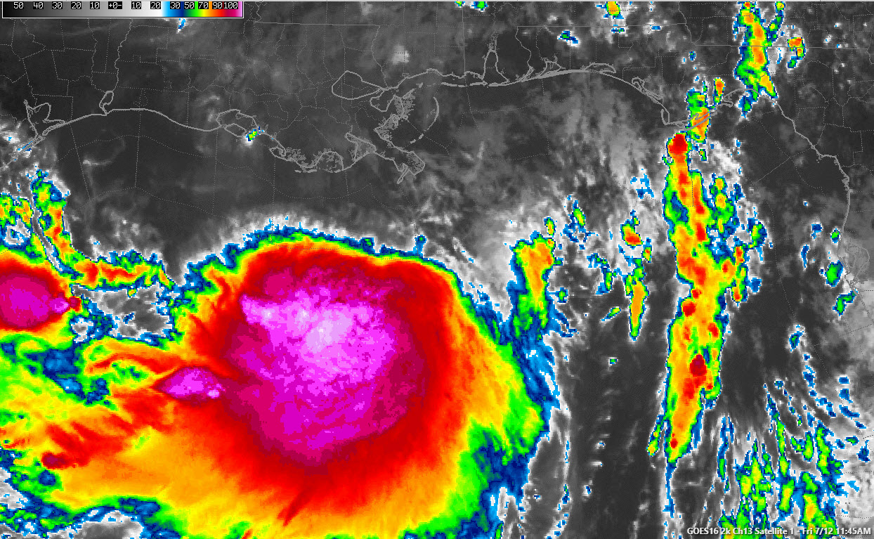
Tropical Storm Barry is definitely becoming better organized this morning. The system has been battling dry air and northerly shear. That shear seems like it will lessen as the storm moves toward the Louisiana coast. Outflow seems to be improving, which is another sign of strengthening, and the convection near the center seems to be exploding.
The central pressure has just dropped to 996 millibars according to the Air Force Hurricane Hunter plane. They did find a flight level wind of 73 knots, which translates to about 67 knots or 78 mph. Barry may become a hurricane this afternoon, although the official forecast does not explicitly call for that to happen still and few of the intensity guidance members show it happening either.
A gust to 62 knots, or 72 mph, occurred a short time ago a the Mississippi Canyon oil platform south of the mouth of the Mississippi River. That anemometer is at 90 meters, which means winds would be higher than at the surface. But it shows that Barry is getting close to hurricane strength.
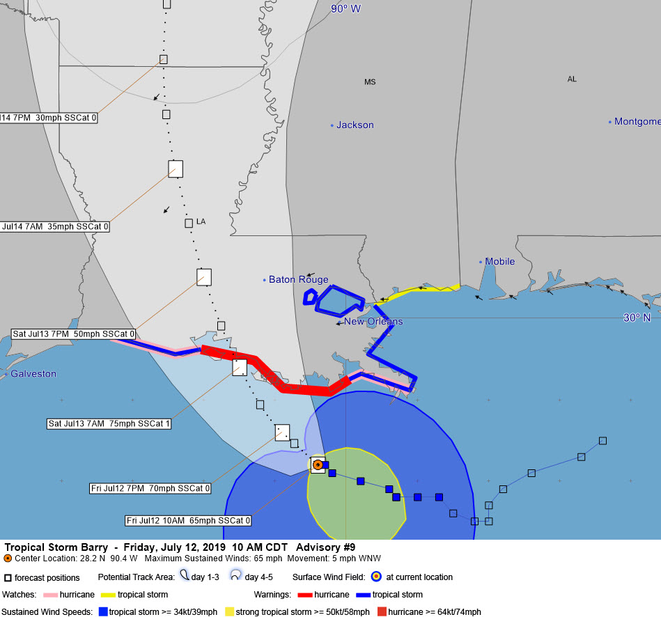
The center of Barry will go inland early tomorrow morning on the Central Louisiana coast near Morgan City. A hurricane warning is in effect from Grand Isle to Intracoastal City. A tropical storm warning is in effect from Cameron to Intracoastal City and from Grand Isle to the Mouth of the Pearl River, at the Louisiana/Mississippi border. This includes metropolitan New Orleans.
The storm will move through Louisiana and into Arkansas Saturday and Sunday. This will place Alabama and the Gulf Coast beaches in the more active right semicircle of the storm. The main impacts will in Louisiana and western Mississippi. But bands of showers and storms will affect western Alabama tomorrow, Sunday, and Monday. This means some heavy rain and storms west of I-65 all three days. Any of those storms that form during the afternoon could produce a threat of spin-up tornadoes over the western counties of Alabama Saturday, Sunday or Monday.
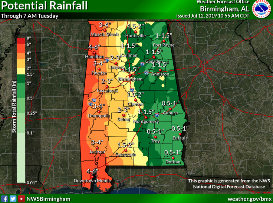
Rainfall amounts across the state will range from 2-4 inches west of I-65 to 1-2 inches east of I-65. Here is an expected rainfall map.
For the beaches of Alabama and Northwest Florida, bands of showers and thunderstorms will be likely, especially along the Alabama coast through Saturday. Winds will be out of the south averaging 20-25 mph and gusting to higher levels at times. The rip current risk will be extreme today and tomorrow along the Alabama coast and high again on Sunday. The threat will be high through the weekend along the Northwest Florida coast as far east of the Beaches of 30A.
Category: Alabama's Weather, ALL POSTS, Tropical
About the Author (Author Profile)
Bill Murray is the President of The Weather Factory. He is the site's official weather historian and a weekend forecaster. He also anchors the site's severe weather coverage. Bill Murray is the proud holder of National Weather Association Digital Seal #0001 @wxhistorianSubscribe
If you enjoyed this article, subscribe to receive more just like it.


