Showers/Storms Remain Possible In A Very Humid Airmass
HUMID SUMMER WEATHER: As this day begins we have a number of showers and storms in progress over Tennessee Valley and some northwest counties of Alabama as a very moist airmass remains in place. Showers and storms will slowly develop to the south and east today, and most communities across the northern half of the state stand a good chance of getting wet at time or two. Highs will be in the 80s with only a limited amount of sun; South Alabama will see low 90s.
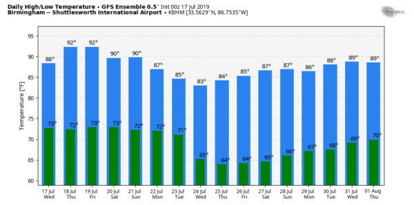
TOMORROW/FRIDAY: A slow moving upper trough (the “ghost” of former Tropical Storm Barry”) will keep the weather somewhat unsettled. Look for a mix of sun and clouds both days with scattered showers and storms; of the two days the highest coverage most likely comes on Friday. Afternoon highs will be in the 88-92 degree range for most places.
THE ALABAMA WEEKEND: Not much change. The sun will be out at times Saturday and Sunday, and showers and storms will be around both days, mainly between 1:00 and 9:00 p.m. (although we can’t rule out a late night or morning shower). No way of knowing in advance exactly when and where the storms fire up. Afternoon highs will be in the 88-91 degree range for most places, and humidity levels will stay high. Pretty much what we expect in mid-summer here.
NEXT WEEK: A surface front is forecast to approach from the north, and this could bring an enhanced coverage of showers and thunderstorms to Alabama Monday and Tuesday. Some of the global models suggest drier will creep into North Alabama Wednesday, but we will believe that when we see it… fronts rarely ge that far south in July. See the Weather Xtreme video for maps, graphics, and more details.
TROPICS: Very dry air covers much of the Atlantic basin, and tropical storm formation is not expected this week.
ON THIS DATE IN 1987: Slow moving thunderstorms caused flooding on the Guadalupe River in Texas resulting in tragic loss of life. A bus and van leaving a youth summer camp stalled near the rapidly rising river, just west of the town of Comfort, or about 50 mile northwest of San Antonio. The powerful surge of water swept away 43 persons, mostly teenagers. Ten drowned in the floodwaters. Most of the others were rescued from treetops by helicopter.
BEACH FORECAST: Click here to see the AlabamaWx Beach Forecast Center page.
WEATHER BRAINS: Don’t forget you can listen to our weekly 90 minute show anytime on your favorite podcast app. This is the show all about weather featuring many familiar voices, including our meteorologists here at ABC 33/40.
CONNECT: You can find me on all of the major social networks…
Facebook
Twitter
Instagram
Pinterest
Snapchat: spannwx
Look for the next Weather Xtreme video here by 4:00 this afternoon… enjoy the day!
Category: Alabama's Weather, ALL POSTS, Weather Xtreme Videos


