

At Midday: Good Bit Of Scattered Showers & Storms Out There
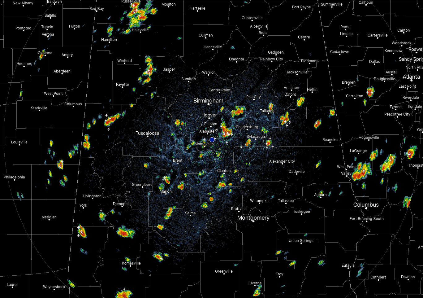
Radar at 12:15 pm shows a good bit of scattered showers and thunderstorms spread out across a large part of Central Alabama. Strongest storms are currently over parts of Shelby County and over parts of Talladega and Coosa counties. Those storms are producing very heavy rainfall, dangerous cloud-to-ground lightning, and gusty winds up to and over 40 MPH. These storms are drifting ever so slowly to the southeast. If you are in close proximity to these storms, go ahead and seek shelter indoors.
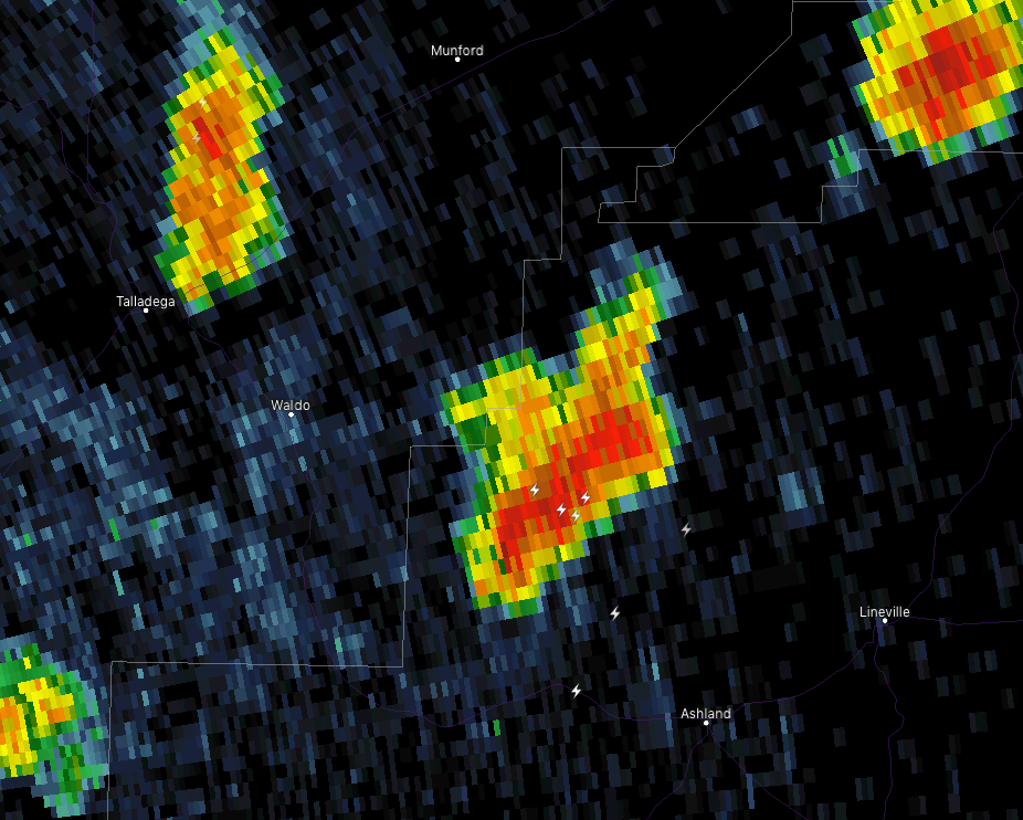
With any thunderstorm today, if you can hear thunder, you are close enough to the parent thunderstorm to be struck by lightning. A bolt of lightning can travel up to and sometimes more than 10 miles away from the parent cell. A perfect example is pictured above with the storm currently just to the northwest of Ashland. There are three cloud-to-ground lightning strikes away and in front of the parent storm that is over three miles away. When thunder roars, go indoors.
SHOWER & T-STORM CHANCES REMAIN THROUGH THE REST OF THE DAY
A stalled boundary will be the focal point for an increased risk of scattered showers and thunderstorms across much of Central Alabama for the remainder of the afternoon and into the evening hours. The highest rain chances will be along and south of the I-59 corridor down to the I-85 corridor, while the rest of the area will have a slightly lower chance of isolated to scattered showers and storms. Afternoon highs will be in the lower to mid-90s. Rain chances will range from 20% to 60% during the day. Much of the activity will die off after the sun goes down but some showers and storm may linger into the late night and overnight hours mainly in the southeastern parts of the area. Lows will be in the mid-60s to the lower 70s across the area.
SCATTERED SHOWERS & STORMS REMAIN POSSIBLE THROUGH THE WEEKEND
Not much change at this point for Friday through Sunday as we’ll continue with an active pattern across Central Alabama. Isolated to scattered showers and storms will be possible on Friday with chances ranging from 30%-40% from northwest to southeast. Highs will be in the upper 80s to the lower 90s. Rain chances will stay higher across Central Alabama on Saturday as the entire area will have a 40%-50% chance of mainly afternoon scattered showers and thunderstorms. Highs will be in the upper 80s to the lower 90s. Much of the same for Sunday as the odds of scattered showers and thunderstorms will be greater during the afternoon hours. Those rain chances top out in the 40%-50% range across the area with highs reaching the upper 80s to the lower 90s.
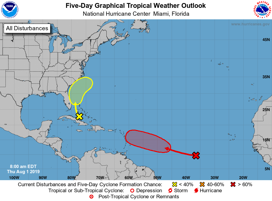
TAKING A LOOK AT THE TROPICS
The disturbance which used to be called Invest 95L is located over Cuba and the Bahamas will move northwest then northward bringing heavy rain and some gusty winds to the Greater Antilles, the Bahamas, and parts of the Florida Peninsula over the next few days. Conditions may become marginally conducive for development over the weekend as the system curves back out to the northeast and away from the US mainland, but the NHC is only giving it a 10% chance of developing into a depression within the next five days.
Invest 96L is currently located about 1,000 miles west-southwest of the Cabo Verde Islands over the eastern Atlantic Ocean. Some slow development is possible over the next couple of days as it moves to the west-northwest at 10-15 MPH. Conditions become more favorable for development over the weekend and a depression is likely to form well east of the Lesser Antilles. NHC has a 70% chance of tropical depression development within the next five days. Most of the models have this one curving back to the north and northeast well before reaching the US mainland.
Another tropical wave has moved off the African coast just behind Invest 96L and will need to be watched.
ON THIS DAY IN WEATHER HISTORY
1989 – Hurricane Chantal made landfall along the Upper Texas coast about sunrise. Chantal deluged parts of Galveston Island and southeastern Texas with 8 to 12 inches of rain. Unofficial totals ranged up to twenty inches. Winds gusted to 82 mph at Galveston and reached 76 mph in the Houston area. Tides were 5 to 7 feet high. The hurricane claimed two lives and caused 100 million dollars damage.
BEACH FORECAST CENTER
Get the latest weather and rip current forecasts for the beaches from Fort Morgan to Panama City on our Beach Forecast Center page. There, you can select the forecast of the region that you are interested in.
ALREADY OFF TO A HOT START IN 2019! ADVERTISE WITH THE BLOG!
After a record-setting 2018 with over 19.7 million page views, AlabamaWx.com is already well on its way to setting another record as we’re nearing 12 million page views so far in 2019! Don’t miss out! We can customize a creative, flexible and affordable package that will suit your organization’s needs. Contact Bill Murray at (205) 687-0782.
E-FORECAST
Get the Alabama Wx Weather Blog’s Seven-Day Forecast delivered directly to your inbox by email twice daily. It is the most detailed weather forecast available in Central Alabama. Subscribe here… It’s free!
CONNECT WITH THE BLOG ON SOCIAL MEDIA
You can find the AlabamaWx Weather Blog on the major social media networks:
Facebook
Twitter
Instagram
WEATHERBRAINS
Don’t forget you can listen to our weekly 90 minute netcast anytime on the web at WeatherBrains.com or on iTunes, Stitcher, or Spotify. This is the show all about weather featuring many familiar voices, including the meteorologists at ABC 33/40.
Category: Alabama's Weather, ALL POSTS
About the Author (Author Profile)
Scott Martin is an operational meteorologist, professional graphic artist, musician, husband, and father. Not only is Scott a member of the National Weather Association, but he is also the Central Alabama Chapter of the NWA president. Scott is also the co-founder of Racecast Weather, which provides forecasts for many racing series across the USA. He also supplies forecasts for the BassMaster Elite Series events including the BassMaster Classic.Subscribe
If you enjoyed this article, subscribe to receive more just like it.


