

The Severe Thunderstorm Warning For Northwestern Jackson, Northeastern Madison And Southeastern Lincoln Counties Will Expire At 4:30 PM CDT
…THE SEVERE THUNDERSTORM WARNING FOR NORTHWESTERN JACKSON…
NORTHEASTERN MADISON AND SOUTHEASTERN LINCOLN COUNTIES WILL EXPIRE AT
430 PM CDT…
The storm which prompted the warning has weakened below severe
limits, and no longer poses an immediate threat to life or property.
Therefore, the warning will be allowed to expire. However gusty
winds and heavy rain are still possible with this thunderstorm.
LAT…LON 3506 8632 3499 8632 3499 8613 3494 8601
3455 8640 3491 8674 3513 8648
TIME…MOT…LOC 2120Z 301DEG 22KT 3485 8640
A Severe Thunderstorm Warning Remains In Effect Until 4:30 PM CDT For Northwestern Jackson, Northeastern Madison And Southeastern Lincoln Counties
Aug 7th @ 4:09 pm

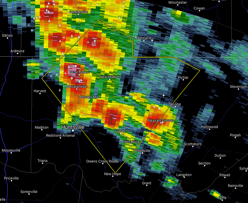
…A SEVERE THUNDERSTORM WARNING REMAINS IN EFFECT UNTIL 430 PM CDT FOR NORTHWESTERN JACKSON…NORTHEASTERN MADISON AND SOUTHEASTERN LINCOLN COUNTIES… At 408 PM CDT, a severe thunderstorm was located near Moores Mill, moving southeast at 25 mph.
HAZARD…60 mph wind gusts.
SOURCE…Radar indicated.
IMPACT…Expect damage to roofs, siding, and trees. Locations impacted include… Northern Huntsville, Moores Mill, Meridianville, Hazel Green, Owens Cross Roads, Skyline, Gurley, Alabama A And M University, New Market and Lincoln.
Severe Thunderstorm Warning Issued For Parts Of Jackson, Madison, And Lincoln (TN) Counties Until 4:30PM
Aug 7th @ 3:56 pm

The National Weather Service in Huntsville Alabama has issued a
* Severe Thunderstorm Warning for…
Northwestern Jackson County in northeastern Alabama…
Northeastern Madison County in north central Alabama…
Southeastern Lincoln County in Middle Tennessee…
* Until 430 PM CDT.
* At 355 PM CDT, a severe thunderstorm was located over Hazel Green, or near Meridianville, moving southeast at 25 mph.
HAZARD…60 mph wind gusts and penny size hail.
SOURCE…Radar indicated.
IMPACT…Expect damage to roofs, siding, and trees.
* Locations impacted include…
Northern Huntsville, Moores Mill, Meridianville, Hazel Green, Owens
Cross Roads, Skyline, Gurley, Alabama A And M University, New
Market and Lincoln.
Category: ALL POSTS
About the Author (Author Profile)
Subscribe
If you enjoyed this article, subscribe to receive more just like it.


