

Quiet At Midday; Strong Storms Possible This Afternoon
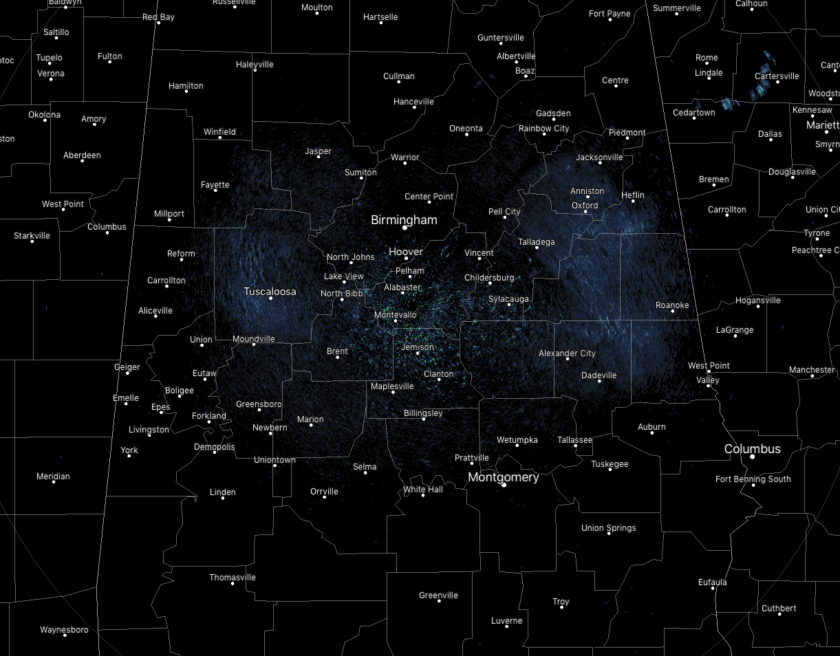
As of 11:10 am, radar is quiet across Central Alabama. It won’t be too long until we’ll start to see showers and thunderstorms pop up with the heating of the day, some of which could be strong to severe (more on that a little later in the post). Temperatures are in the mid-80s to the lower 90s across Central Alabama. Birmingham was at 88 degrees, while Uniontown was the hot spot at 92 degrees. The cool spot was Haleyville at 84 degrees.
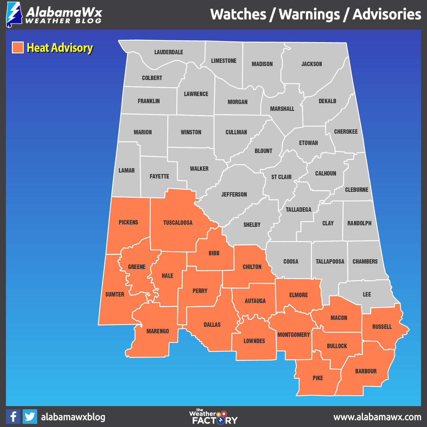
A HEAT ADVISORY continues until 9:00 pm tonight for these counties in Central Alabama: Autauga, Barbour, Bibb, Bullock, Chilton, Dallas, Elmore, Greene, Hale, Lowndes, Macon, Marengo, Montgomery, Perry, Pickens, Pike, Russell, Sumter, and Tuscaloosa. Afternoon highs reaching the 93-97 degree range, and with the amount of moisture in the air, heat index values will reach the 105-108 degree range in the advisory locations.
Just taking a peek into the weekend and the start of next week, we will only be getting hotter as heat advisories may be needed for Saturday and Sunday with the potential of excessive heat warnings needed for Monday and Tuesday as heat index values could exceed 110 degrees.
We continue to have a very similar setup today that we have seen over the past few days where we’ll have a few disturbances move in from the northwest. Those disturbances, along with a stalled out surface boundary across the area, will be a focal point for the convective development. The main concentration of storms will be along and south of a line from Fayette to Clanton to Troy, but a few isolated stronger storms may be possible north of that. NWS Birmingham has nearly the entire area in a Marginal Risk for severe storms through 9:00 pm this evening. Isolated damaging winds to 60 MPH will be the main threat. Afternoon highs will be in the upper 80s to the upper 90s across the area from northwest to southeast. Storms will begin to die off after sunset, but we’ll continue to have a chance of showers and thunderstorms through the evening and into the late-night hours. One or two of these storms may be strong with gusty winds. Lows will be in the lower to mid-70s.
![]() A FREE, FUN WEATHER PREPAREDNESS & SAFETY FESTIVAL FOR THE WHOLE FAMILY
A FREE, FUN WEATHER PREPAREDNESS & SAFETY FESTIVAL FOR THE WHOLE FAMILY
WeatherReady Fest is coming to Huntsville, Alabama on September 7, 2019, from 10:00 am to 4:00 pm. Family-friendly games, fun learning activities, large response vehicles, and enlightening speakers will highlight this big, one-day weather festival on the campus of the University of Alabama in Huntsville. Special guests include The Weather Channel’s Nick Walker, ABC 33/40’s Chief Meteorologist James Spann, and Owlie Skywarn. Each visitor will receive their very own passport booklet. Collect stamps from exhibitor for your chance to win door prizes. Tours of UAH’s SWIRLL and the NWS Huntsville office will be available as well. Get your free timed tickets quickly as they will not last long. More information and a link to the ticket site is available on the festival website at www.weatherreadyfest.com. The tickets are free and are issued for specific hours to maximize the number of people that can visit. I hope to see you there!
BEACH FORECAST CENTER
Get the latest weather and rip current forecasts for the beaches from Fort Morgan to Panama City on our Beach Forecast Center page. There, you can select the forecast of the region that you are interested in.
ALREADY OFF TO A HOT START IN 2019! ADVERTISE WITH THE BLOG!
After a record-setting 2018 with over 19.7 million page views, AlabamaWx.com is already well on its way to setting another record as we’re just topped 12 million page views so far in 2019! Don’t miss out! We can customize a creative, flexible and affordable package that will suit your organization’s needs. Contact Bill Murray at (205) 687-0782.
E-FORECAST
Get the Alabama Wx Weather Blog’s Seven-Day Forecast delivered directly to your inbox by email twice daily. It is the most detailed weather forecast available in Central Alabama. Subscribe here… It’s free!
CONNECT WITH THE BLOG ON SOCIAL MEDIA
You can find the AlabamaWx Weather Blog on the major social media networks:
Facebook
Twitter
Instagram
WEATHERBRAINS
Don’t forget you can listen to our weekly 90 minute netcast anytime on the web at WeatherBrains.com or on iTunes, Stitcher, or Spotify. This is the show all about weather featuring many familiar voices, including the meteorologists at ABC 33/40.
Category: Alabama's Weather, ALL POSTS, Severe Weather
About the Author (Author Profile)
Scott Martin is an operational meteorologist, professional graphic artist, musician, husband, and father. Not only is Scott a member of the National Weather Association, but he is also the Central Alabama Chapter of the NWA president. Scott is also the co-founder of Racecast Weather, which provides forecasts for many racing series across the USA. He also supplies forecasts for the BassMaster Elite Series events including the BassMaster Classic.Subscribe
If you enjoyed this article, subscribe to receive more just like it.


