

A Few Strong Storms Out There Just After Midday
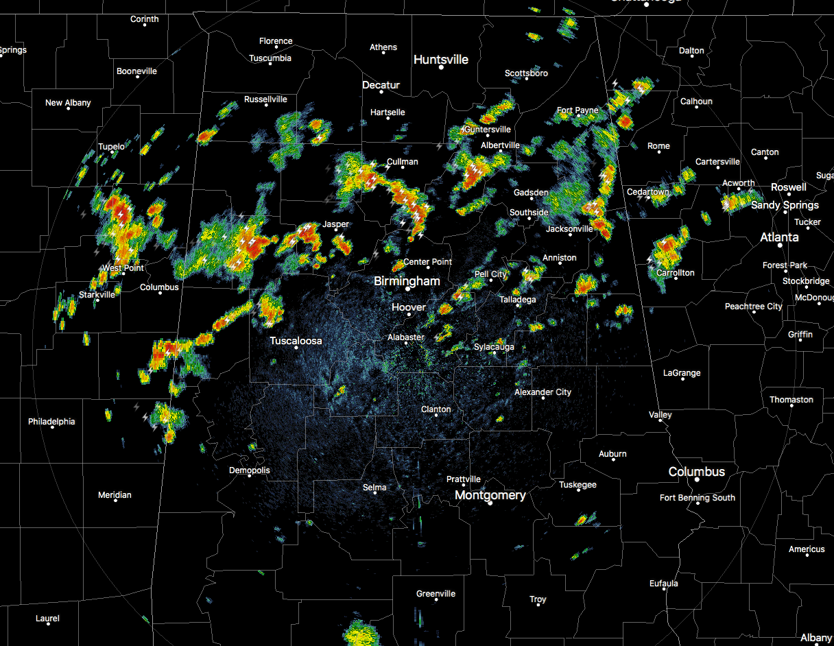
At 1:10 pm, we have a good bit of scattered shower and thunderstorm activity over the northern half of Central Alabama and up into the southern parts of North Alabama. A few of these are currently strong with gusty winds, dangerous cloud-to-ground lightning, and very heavy rainfall. The stronger cells are affecting portions of Fayette and Blount counties. All of the activity is slowly moving to the east at 15-20 MPH.
We have a moist environment in place with precipitable water values approaching 2.00 inches, that means we could see some heavier amounts in the larger thunderstorms. We’ll have scattered to numerous showers and storms likely over much of Central Alabama with rain chances being a little less along and south of the I-85 corridor. Afternoon highs will be in the upper 80s to the mid-90s across the area.
For any high school football games that will play tonight, or for those attending the Sidewalk Film Festival’s opening night, showers and thunderstorms will remain likely until an hour or so after sunset, with activity quickly diminishing by the late-night hours. Temperatures at 6:00 pm will be in the 80s across the area and dropping into the mid to upper 70s by 10:00 pm. For the overnight hours, all rain will be gone and skies will be partly cloudy. Lows will be in the upper 60s to the lower 70s.
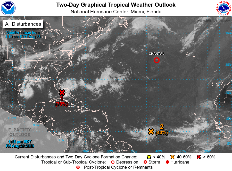
Chantal is a depression right now and is expected to become a remnant low sometime later today or tonight. Current maximum sustained winds are at 30 MPH.
Our main focus will be just offshore of the Florida Peninsula as Invest 98-L will likely become a depression or Tropical Storm Dorian over the weekend. Nearly all of the plots keep the disturbance over the Atlantic just offshore of the southeastern coast. We’ll need to watch as we may have some influence from well up north that may keep the disturbance closer to the shore. It will be no threat to Central Alabama.
Just behind that just east of the Winward Island is Invest 99-L. We’ll need to watch this one closely as well as forecast models have this ramping up to a tropical storm or hurricane by late Monday. One important item that may limit development will be a large amount of drier air that is nearby. If the dry air is pulled into the disturbance, further development may be slowed or stopped. NHC is giving it 50/50 odds of developing into a depression over the next five days as it is predicted to move to the west-northwest.
BEACH FORECAST CENTER
Get the latest weather and rip current forecasts for the beaches from Fort Morgan to Panama City on our Beach Forecast Center page. There, you can select the forecast of the region that you are interested in.
WEATHERREADY FEST: A FREE PREPAREDNESS & SAFETY FESTIVAL FOR THE ENTIRE FAMILY
The National Weather Association Foundation is bringing WeatherReady Fest to the campus of the University of Alabama in Huntsville on September 7, 2019, from 10:00 am to 4:00 pm. This one-day festival will include family-friendly games, fun learning activities, large response vehicles, and enlightening speakers. Local and national celebrities will make special appearances, along with the NWA’s very own, Owlie Skywarn. Over 6,000 attendees showed up in St. Louis for last year’s event… let’s break that record this year. Get your free timed tickets now as they are going fast. More information and a link to tickets are available on the festival website at www.weatherreadyfest.com. Hope to see you there!
SIDEWALK FILM FESTIVAL
The 21st Annual Sidewalk Film Festival kicks off tonight and goes through Sunday, August 25th. Not only will there be great features to be seen, but you can take part in panel discussions, workshops, and even parties. For more information and for tickets, please go to sidewalkfest.com for tickets.
ALREADY OFF TO A HOT START IN 2019! ADVERTISE WITH THE BLOG!
After a record-setting 2018 with over 19.7 million page views, AlabamaWx.com is already well on its way to setting another record as we’re just topped 12.3 million page views so far in 2019! Don’t miss out! We can customize a creative, flexible and affordable package that will suit your organization’s needs. Contact Bill Murray at (205) 687-0782.
E-FORECAST
Get the Alabama Wx Weather Blog’s Seven-Day Forecast delivered directly to your inbox by email twice daily. It is the most detailed weather forecast available in Central Alabama. Subscribe here… It’s free!
CONNECT WITH THE BLOG ON SOCIAL MEDIA
You can find the AlabamaWx Weather Blog on the major social media networks:
Facebook
Twitter
Instagram
WEATHERBRAINS
Don’t forget you can listen to our weekly 90 minute netcast anytime on the web at WeatherBrains.com or on iTunes, Stitcher, or Spotify. This is the show all about weather featuring many familiar voices, including the meteorologists at ABC 33/40.
Category: Alabama's Weather, ALL POSTS
About the Author (Author Profile)
Scott Martin is an operational meteorologist, professional graphic artist, musician, husband, and father. Not only is Scott a member of the National Weather Association, but he is also the Central Alabama Chapter of the NWA president. Scott is also the co-founder of Racecast Weather, which provides forecasts for many racing series across the USA. He also supplies forecasts for the BassMaster Elite Series events including the BassMaster Classic.Subscribe
If you enjoyed this article, subscribe to receive more just like it.


