

Dorian Remains Stationary As Of 9:00 PM
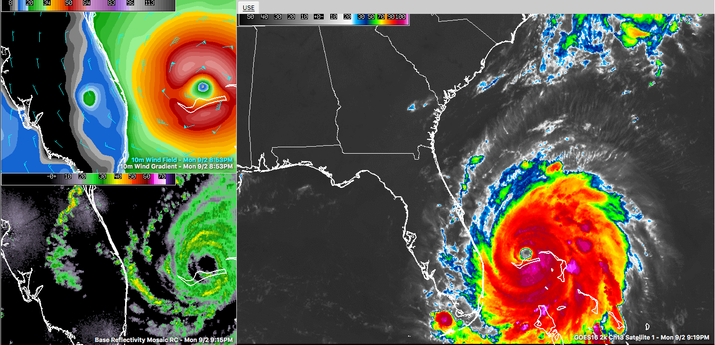
Hurricane Dorian continues to wreak havoc over the Grand Bahama Island as the eye continues to remain stationary as of 9:00 pm CT. At this point, the center of Dorian is located only 25 miles to the northeast of Freeport, Grand Bahama Island, and maximum sustained winds are at 140 MPH (category 4). No matter the wind speed at this point, damage and flooding continue across the island.

The forecast track remains the same at this time, taking the center very close to the east coast of Florida and moving north and eventually northeast along the Georgia and Carolina coasts before finally moving away from the US on Friday. An updated track will be out around 10:00 pm.
Winds across the Florida Peninsula are already out of the north and northwest around 10-15 knots, but those will only pick up in intensity as Dorian will finally start to move away from the Bahamas on Tuesday afternoon. Any slight jog to the west in the track will greatly increase the winds and storm surge along the Florida and Georgia coasts. Rough surf and dangerous rip currents are already occurring.
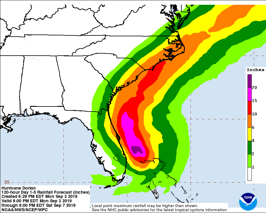
Rainfall amounts of 6.00-10.00 inches could be seen between now and Sunday evening, especially along the northern Atlantic Coast of Florida up to the shores of North Carolina. Some localized amounts up to 15.00 inches may be possible. Flooding will be possible all along the Atlantic Coast of the southeastern US due to the heavy rainfall and storm surge.
Here is the latest bulletin out from the NHC at 9:00 pm CT:
Hurricane Dorian Tropical Cyclone Update
NWS National Hurricane Center Miami FL AL052019
1000 PM EDT Mon Sep 02 2019
…EXTREMELY DANGEROUS DORIAN REMAINS STATIONARY AND CONTINUES TO THRASH GRAND BAHAMA ISLAND…
Residents should remain in shelter on Grand Bahama Island as they are currently experiencing the eyewall of Dorian. Residents in the Abacos should also continue to stay in their shelter until conditions subside later tonight.
Hazards:
– Wind Gusts to 165 mph
– Storm Surge 12 to 18 feet above normal tide levels with higher destructive waves
These hazards will continue over Grand Bahama Island through Tuesday morning, causing extreme destruction on the island.
SUMMARY OF 1000 PM EDT…0200 UTC…INFORMATION
———————————————-
LOCATION…26.8N 78.4W
ABOUT 25 MI…40 KM NE OF FREEPORT GRAND BAHAMA ISLAND
ABOUT 105 MI…170 KM E OF WEST PALM BEACH FLORIDA
MAXIMUM SUSTAINED WINDS…140 MPH…230 KM/H
PRESENT MOVEMENT…STATIONARY
MINIMUM CENTRAL PRESSURE…942 MB…27.82 INCHES
About the Author (Author Profile)
Scott Martin is an operational meteorologist, professional graphic artist, musician, husband, and father. Not only is Scott a member of the National Weather Association, but he is also the Central Alabama Chapter of the NWA president. Scott is also the co-founder of Racecast Weather, which provides forecasts for many racing series across the USA. He also supplies forecasts for the BassMaster Elite Series events including the BassMaster Classic.Subscribe
If you enjoyed this article, subscribe to receive more just like it.


