

Hurricane Dorian: Expected Impacts Along the Southeast Coast
By Meteorologist Johnny Parker
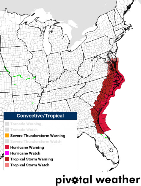
Hurricane warnings are in effect for the coasts of South and North Carolina.
Savannah, Georgia: There is the potential for winds here to reach 58 to 73mph with locations near the coast reaching 74 to 110 mph. The storm surge along the Savannah coast could reach greater than 6 feet above ground level. Major flooding rain is expected with a few tornadoes possible.
Charleston, South Carolina: A Storm Surge Warning remains in effect for the Charleston area. At peak surge there is the potential for inundation up to 7 feet above ground level. Storm surge and flooding will remain a threat for low lying areas through Saturday morning. A Flash Flood Watch is in effect. As much as 10-15 inches of rainfall is expected with locally higher amounts possible. Locations along the coast as well as further inland will receive the equivalent of Category 1 force winds ranging from 74-90 mph with gusts up to 110 mph. Tropical Storm force winds are expected to impact the area until Friday morning.
Myrtle Beach, South Carolina: A Flash Flood Watch remains in effect through Friday morning. Eight to ten inches of rainfall is expected. The storm surge warning includes this area and all of coastal South Carolina. Winds are expected to be at Category 1 force, 74-90 mph with gusts reaching 110 mph, on Thursday morning through the afternoon hours.
Wilmington, North Carolina: A High Surf Advisory remains in effect for the area until the early morning hours on Friday. Waves up to 12 feet are expected as well as very strong rip currents. A Rip Current Advisory is in effect until Thursday evening. Strong winds above hurricane force, 74-90 mph, will be felt along the coastline.
Morehead City, North Carolina: Winds are expected to gust up to 115 mph with peak intensity Thursday evening through Friday afternoon. The Storm Surge Warning will likely continue through Sunday afternoon. Surge prone areas may see up to 7 feet above ground level. Flash flooding remains a great concern. A Watch is in effect with 6-10 inches of rainfall expected. As with all the coastal areas, the situation is favorable for a few tornadoes to occur.
Cape Hatteras, North Carolina: There is considerable potential for life-threatening impacts in the Hatteras area. Its location places it near the strongest winds that Dorian may produce. Gusts up to 120 mph are expected early Friday morning through the afternoon hours. The angle of Dorian’s approach will potentially limit storm surge to 3 feet above ground. However, the Cape’s low lying topography makes this a significant threat. Rainfall is expected to reach 6-10 inches and a Flash Flood Watch remains in effect.
About the Author (Author Profile)
Bill Murray is the President of The Weather Factory. He is the site's official weather historian and a weekend forecaster. He also anchors the site's severe weather coverage. Bill Murray is the proud holder of National Weather Association Digital Seal #0001 @wxhistorianSubscribe
If you enjoyed this article, subscribe to receive more just like it.


