

Jerry Not Far Away From Becoming A Major Hurricane
SUMMARY AS OF 10:00 PM CT
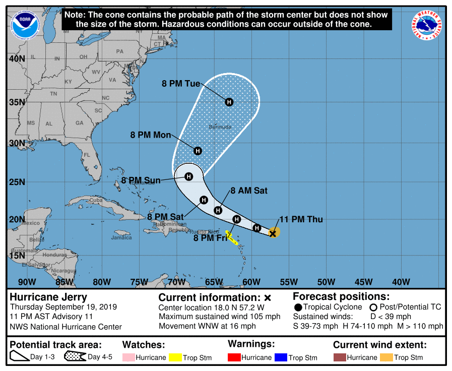
LOCATION…18.0N 57.2W
ABOUT 385 MI…625 KM E OF THE NORTHERN LEEWARD ISLANDS
MAXIMUM SUSTAINED WINDS…105 MPH…165 KM/H
PRESENT MOVEMENT…WNW OR 295 DEGREES AT 16 MPH…26 KM/H
MINIMUM CENTRAL PRESSURE…976 MB…28.82 INCHES
A Tropical Storm Watch is in effect for St. Maarten, St. Martin, St. Barthelemy, Saba, and St. Eustatius.

The Air Force Hurricane Hunters investigating Jerry this evening found that the hurricane has strengthened. Based on the 700 mb flight-level winds from the aircraft, the current intensity is estimated to be about 90 kt. It should be noted that this is substantially higher than the intensity estimates provided from satellite data and underscores the value of aerial reconnaissance of tropical cyclones. An expected increase in vertical shear in a day or so is expected to cause a weakening trend to commence in 12 to 24 hours, however, Jerry should remain a hurricane throughout the forecast period. This NHC intensity forecast is higher than the previous one mainly due to the higher initial wind speed and is near or a little above the model consensus.
Jerry remains on track and continues to move west-northwestward or 295/14 kt. Over the next couple of days, the hurricane should continue this general motion with some slowing of forward speed as it moves along the southwestern periphery of a subtropical ridge. Thereafter, Jerry is likely to turn to the northwest, then north-northwest, and north as it moves through a weakness in the ridge. The track prediction models are in good agreement on this scenario, and the official forecast is quite close to the previous one. This is also very similar to the NOAA corrected consensus model, or HCCA, track.
Key Messages: Although the core of Jerry is expected to move north of the northern Leeward Islands, life-threatening flash floods are possible, along with tropical-storm-force winds in some areas.
About the Author (Author Profile)
Scott Martin is an operational meteorologist, professional graphic artist, musician, husband, and father. Not only is Scott a member of the National Weather Association, but he is also the Central Alabama Chapter of the NWA president. Scott is also the co-founder of Racecast Weather, which provides forecasts for many racing series across the USA. He also supplies forecasts for the BassMaster Elite Series events including the BassMaster Classic.Subscribe
If you enjoyed this article, subscribe to receive more just like it.


