

Jerry Is Much Weaker at 1:00 PM
SUMMARY & FORECAST DISCUSSION AT 1:00 PM CT
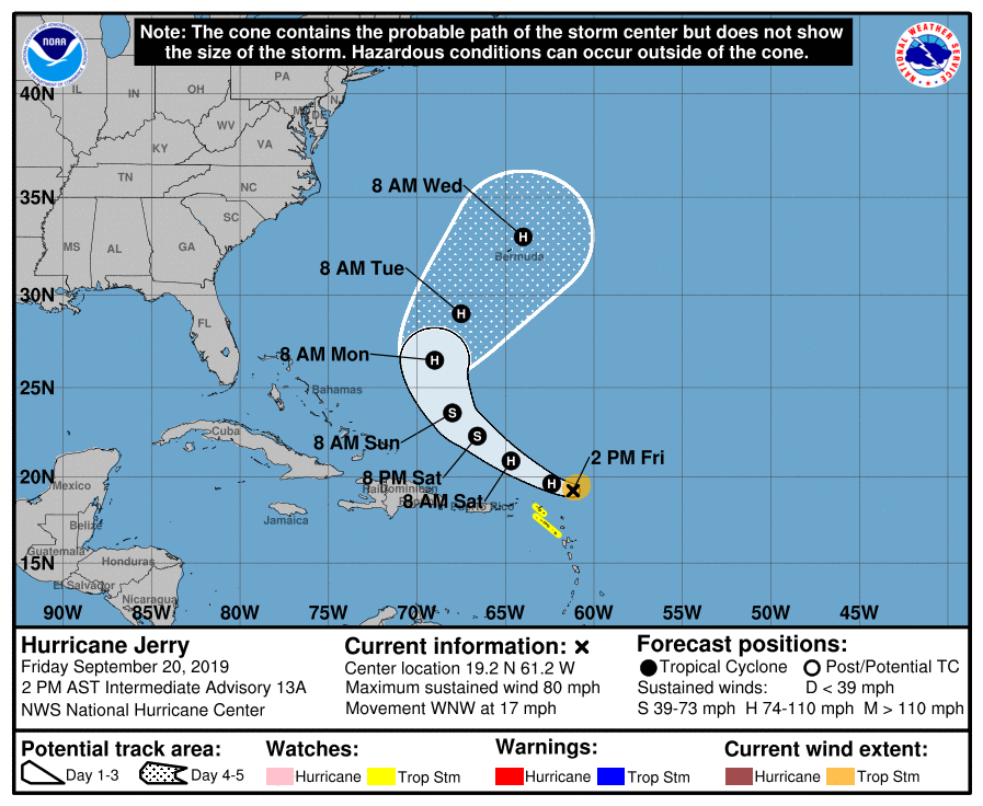
LOCATION…19.2N 61.2W
ABOUT 110 MI…180 KM NNE OF BARBUDA
ABOUT 130 MI…210 KM ENE OF ANGUILLA
MAXIMUM SUSTAINED WINDS…80 MPH…130 KM/H
PRESENT MOVEMENT…WNW OR 295 DEGREES AT 17 MPH…28 KM/H
MINIMUM CENTRAL PRESSURE…990 MB…29.24 INCHES
A Tropical Storm Watch continues for St. Maarten, St. Martin, St. Barthelemy, Saba, and St. Eustatius.
At 200 PM AST (1800 UTC), the center of Hurricane Jerry was located near latitude 19.2 North, longitude 61.2 West. Jerry is moving toward the west-northwest near 17 mph (28 km/h). On the forecast track, the center of Jerry will move north of the northern Leeward Islands later today, pass well north of Puerto Rico on Saturday, be well east-northeast of the southeastern Bahamas on Sunday and turn northward on Monday.
Data from the Air Force Reserve and NOAA Hurricane Hunter aircraft indicate that the maximum sustained winds have decreased to near 80 mph (130 km/h) with higher gusts. Further weakening is forecast during the next day or so, with some re-strengthening possible early next week.
Hurricane-force winds extend outward up to 15 miles (30 km) from the center and tropical-storm-force winds extend outward up to 80 miles (130 km).
The estimated minimum central pressure from the plane data is 990 MB (29.24 inches).
HAZARDS AFFECTING LAND
RAINFALL: Jerry is expected to produce 1 to 3 inches of rainfall, with isolated maximum totals of 4 to 6 inches from Barbuda northwest across St. Maarten, Anguilla, and Anegada. This rainfall may produce life-threatening flash floods.
Jerry is forecast to produce total rainfall accumulations of 1 to 2 inches with maximum amounts of 3 inches across the Virgin Islands and Puerto Rico.
WIND: Tropical storm conditions are possible within the watch areas later today.
SURF: Swells generated by Jerry are affecting portions of the northern Leeward Islands. These swells are likely to cause life-threatening surf and rip current conditions.
About the Author (Author Profile)
Scott Martin is an operational meteorologist, professional graphic artist, musician, husband, and father. Not only is Scott a member of the National Weather Association, but he is also the Central Alabama Chapter of the NWA president. Scott is also the co-founder of Racecast Weather, which provides forecasts for many racing series across the USA. He also supplies forecasts for the BassMaster Elite Series events including the BassMaster Classic.Subscribe
If you enjoyed this article, subscribe to receive more just like it.


