

Lorenzo Weakens A Little; Still A Category 4 Hurricane
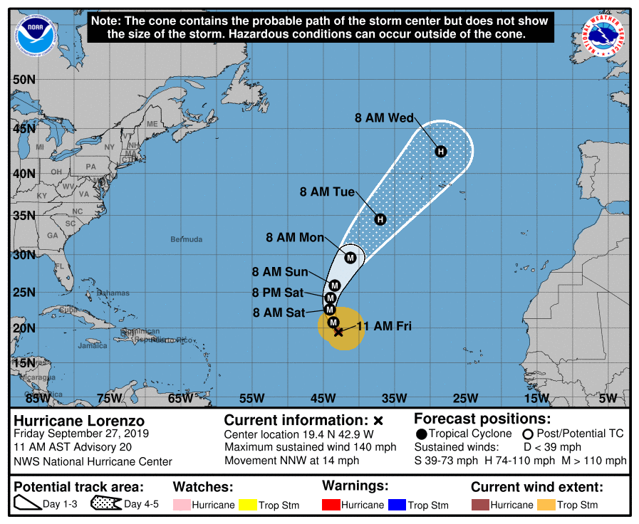
SUMMARY OF 1000 AM CDT INFORMATION
LOCATION…19.4N 42.9W
ABOUT 1600 MI…2575 KM SW OF THE AZORES
MAXIMUM SUSTAINED WINDS…140 MPH…220 KM/H
PRESENT MOVEMENT…NNW OR 330 DEGREES AT 14 MPH…22 KM/H
MINIMUM CENTRAL PRESSURE…943 MB…27.85 INCHES
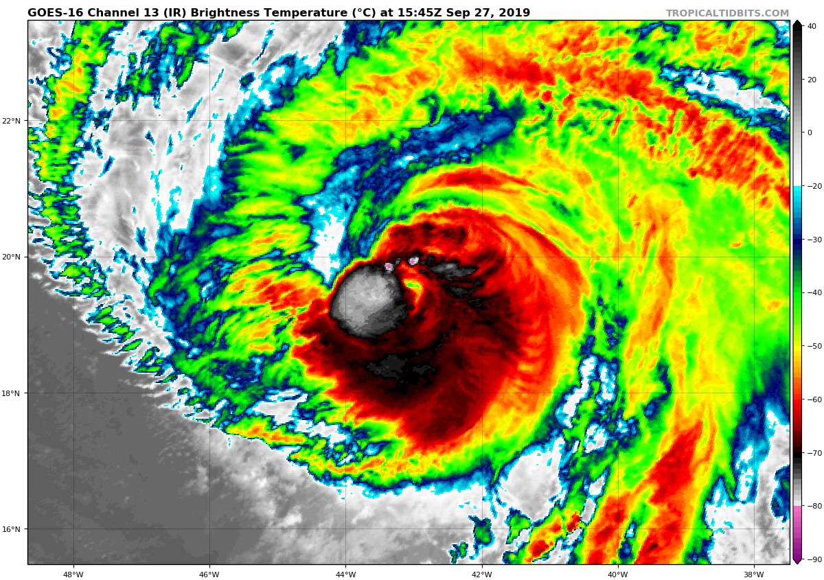
The structure of Lorenzo in conventional satellite imagery has decayed a little since the last advisory, with the eye becoming less distinct and the eyewall convection becoming more asymmetric. There is no current microwave imagery to show whether this weakening might be due to the start of an eyewall replacement cycle or not. The various subjective and objective satellite intensity estimates have decreased a little, so the initial intensity is reduced to 120 kt. The hurricane has excellent cirrus outflow in all directions except to the southwest.
The initial motion is 330/12 kt. There is no change in the track forecast philosophy or the forecast confidence, as Lorenzo should turn northward and then northeastward during the next few days as it moves around the western edge of a mid-level ridge centered over the eastern Atlantic. By the end of the forecast period, Lorenzo is expected to accelerate northeastward in the mid-latitude westerlies ahead of a deep-layer trough approaching from the west. The new forecast track is nudged a little to the left of the previous track-based mainly on the initial position, and it lies near the various consensus models.
Lorenzo is currently passing over a tongue of slightly cooler sea surface temperatures, and it is forecast to reach slightly warmer water in 12-24 h. After that, it stays over sea surface temperatures near 28C through about 72 h. During this time, the intensity will be controlled mainly by internal eyewall replacement cycles and some ups and downs in the vertical shear as the hurricane interacts with a couple of upper-level troughs. The intensity guidance shows a slow weakening trend during this time, and the NHC intensity forecast follows this. However, it would not be surprising to see some fluctuations in intensity occur. After 72 h, the cyclone will become embedded in the mid-latitude westerlies and move over much colder water. This and the approach of the aforementioned deep-layer trough will lead to extratropical transition that will be underway, but likely not complete, by 120 h.
About the Author (Author Profile)
Scott Martin is an operational meteorologist, professional graphic artist, musician, husband, and father. Not only is Scott a member of the National Weather Association, but he is also the Central Alabama Chapter of the NWA president. Scott is also the co-founder of Racecast Weather, which provides forecasts for many racing series across the USA. He also supplies forecasts for the BassMaster Elite Series events including the BassMaster Classic.Subscribe
If you enjoyed this article, subscribe to receive more just like it.


