

Blast Furnace Continues Pumping In The Heat
For Today…
High pressure continues to dominate our weather over the southeast which means for us more heat and mainly dry across Central Alabama. There may be a few isolated to scattered showers form during the afternoon hours across the extreme eastern portions of the area, but dry of the rest. Highs will top out in the mid to upper 90s this afternoon. Any shower activity quickly diminishes after sunset and skies will be mostly clear to partly cloudy. Lows will be in the upper 60s to the lower 70s.

Code Orange Air Quality Alert…
We have a Code Orange Air Quality Alert for Jefferson and Shelby counties throughout the day today as ground-level ozone concentrations are expected to reach levels that are unhealthy for sensitive groups.
For Sunday…
Plenty of sunshine and plenty of heat as we’ll stay dry throughout the day. Skies will be mostly clear and afternoon highs will be right back up in the mid to upper 90s across the area.
For Monday…
Much of the same story to start off the work week… Sunny skies and remaining very hot. Highs look to be in the mid to upper 90s again.
For Tuesday…
Another mainly sunny day but there may be just enough moisture to squeeze out a few isolated afternoon showers and storms, but the risk will be very small. Highs will be in the mid-90s.
For Wednesday…
A cold front will start to approach the state from the north, but there will be no impact from it on Hump Day. Mostly sunny skies and highs will be in the mid-90s.
For Thursday…
The front gets even closer to the area and we could see a few isolated to scattered showers and thunderstorms during the afternoon and early evening hours, but I still believe that our rain chances will remain very small at best. Highs will be back up into the mid to upper 90s.
For Friday…
The front starts to work through the area during the second half of the day which will bring us a slight chance of isolated to scattered showers and thunderstorms. The front will only bring slightly cooler temperatures but we’ll still top out in the 90s across the area.
Taking a Peek Into Voodoo Land For Next Weekend…
We look to continue with the mainly dry and mainly hot pattern across Central Alabama as we’ll have a very small chance of isolated showers and storms during the afternoon hours and highs in the upper 80s to the mid-90s.
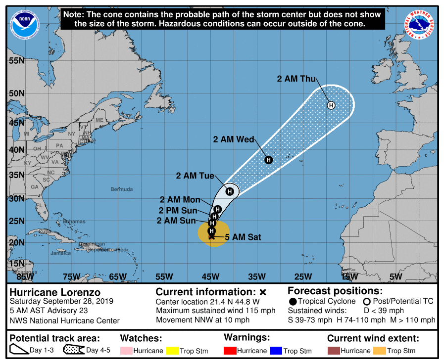
The Tropics…
We only have one storm in the Atlantic Basin and that is Hurricane Lorenzo which has maximum winds at 115 MPH. He will continue to be a bother to the fish as the track keeps him over the open Atlantic while slowly weakening. The rest of the Atlantic Basin is quiet.
Category: Alabama's Weather, ALL POSTS, Weather Xtreme Videos
About the Author (Author Profile)
Scott Martin is an operational meteorologist, professional graphic artist, musician, husband, and father. Not only is Scott a member of the National Weather Association, but he is also the Central Alabama Chapter of the NWA president. Scott is also the co-founder of Racecast Weather, which provides forecasts for many racing series across the USA. He also supplies forecasts for the BassMaster Elite Series events including the BassMaster Classic.Subscribe
If you enjoyed this article, subscribe to receive more just like it.


