


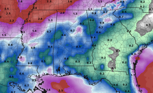
RAINFALL TOTALS FOR THE NEXT SEVEN DAYS
The QPF map shows a mix of colors over the state of Alabama which means we finally get some rainfall. Much of Central Alabama is forecast to get over 1/2-inch to nearly 1-inch of rain over the next seven days while some in the northern parts of the state could get up to 2 inches. While it’s not drought-busting rainfall, it may keep conditions from worsening.
BACK DOOR WEDGE BRINGS BETTER RAIN CHANCES ON SATURDAY
We may continue our streak of record-breaking high temperatures across parts of the area, but a back door wedge will be forcing in more moisture-rich air into the eastern parts of Central Alabama. This will bring a decent chance of scattered afternoon and early evening showers and thunderstorms for the entire area, but the higher risks will be on the eastern half of the area. Afternoon highs will reach the mid-90s across the area with a few hitting the upper 90s. Rain chances will be in the 20%-50% range from west to east. For tonight, the focus of the better rain chances shifts to the northwestern parts of the area. Those chances will range from 20-50% from southeast to northwest. Lows will be in the mid to upper 60s for most.
BYE-BYE 90s, HELLO COOLER WEATHER & INCREASED RAIN CHANCES
Sometimes you would hate for it to rain on a weekend, but after the miserable and dry late summer and early fall, I’m sure most of us would take a few showers across Central Alabama. A cold front will be approaching from the northwest and with an already-moist atmosphere out ahead of it, we’ll see higher rain chances especially for the northwestern parts of the area. Afternoon highs will be in the mid to upper 80s. Rain chances will be in the 20%-60% range from southeast to northwest. Those rain chances will actually rise during the late-night and overnight hours as the front starts to move into the northwest corner of Central Alabama.
MONDAY & TUESDAY
Our real first shot of fall weather will come on Monday as the cold front will continue to work through Central Alabama. We’ll have periods of showers and a few claps of thunder, but no severe weather is expected. Highs will be in the lower 70s to the upper 80s across the area from northwest to southeast. The front will be out of the area on Tuesday, but a few lingering showers are possible over the southeastern portions during the day. Skies will be clearing behind that with highs reaching the upper 70s to the mid-80s across the area from north to south.
WEDNESDAY & THURSDAY
This latest run has introduced a small chance of a few isolated showers across Central Alabama during the heating of the day on Wednesday, especially for the southern half of the area. Highs will be back up in the lower to mid-80s. Much of the same story for Thursday, but the focus of the small chance of isolated showers move to the western parts of the state as another cold front approaches from the west. Highs will be in the lower to mid-80s.
THE END OF THE WORK WEEK
The cold front will move through Central Alabama through the daylight hours but it will be losing its punch as it moves eastward. Rain chances will be highest during the morning hours on the western side of the area, but at this point, those rain chances only top out at 30%. The front looks to lose moisture as it moves through the area, so rain chances will diminish somewhat throughout the day. Highs will be in the upper 70s to the mid-80s.
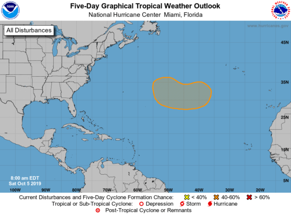
THE TROPICS
For now, all of the Atlantic Basin is quiet, but in a few days, we could see a tropical disturbance develop over the northern Atlantic in between the Azores and Bermuda. There is a medium chance of tropical or subtropical development with this disturbance during the middle of next week as it moves west as the NHC is giving it a 40% chance of growing into a depression.
BEACH FORECAST CENTER
Get the latest weather and rip current forecasts for the beaches from Fort Morgan to Panama City on our Beach Forecast Center page. There, you can select the forecast of the region that you are interested in.
ALREADY OFF TO A HOT START IN 2019! ADVERTISE WITH THE BLOG!
After a record-setting 2018 with over 19.7 million page views, AlabamaWx.com is already well on its way to another great year as we’ve just topped 13.8 million page views so far in 2019! Don’t miss out! We can customize a creative, flexible and affordable package that will suit your organization’s needs. Contact Bill Murray at (205) 687-0782.
E-FORECAST
Get the Alabama Wx Weather Blog’s Seven-Day Forecast delivered directly to your inbox by email twice daily. It is the most detailed weather forecast available in Central Alabama. Subscribe here… It’s free!
CONNECT WITH THE BLOG ON SOCIAL MEDIA
You can find the AlabamaWx Weather Blog on the major social media networks:
Facebook
Twitter
Instagram
WEATHERBRAINS
Don’t forget you can listen to our weekly 90 minute netcast anytime on the web at WeatherBrains.com or on iTunes, Stitcher, or Spotify. This is the show all about weather featuring many familiar voices, including the meteorologists at ABC 33/40.


