

Heatwave is Over, Decent Rain Chances Monday, Drier and Slightly Cooler Rest of the Week
The sound of thunder and gentle rain last night was music to my ears. It had not rained at my house since September 11th. The 0.45 inches that fell last night won’t break any droughts, but we will take anything we can get. And we will get more over the next couple of days.
IT FINALLY RAINED AT THE AIRPORT TOO! Birmingham-Shuttlesworth International Airport got rain late last evening when a band of showers and storms moved through. It was the first measurable rain at the Airport since September 14th. The 20-day rainless streak has only been surpassed by 40 other streaks in history, quite remarkable.
LAST ROUND OF RECORDS: 97F at Tuscaloosa and Birmingham were both records for the date. Birmingham’s broke the previous record of 94F set in 1924 and Tuscaloosa’s tied the record of 97F set in 1954. It was the ninth consecutive daily record high at Birmingham. Huntsville’s 97F was a new record for the date and the 98F in Muscle Shoals was as well.
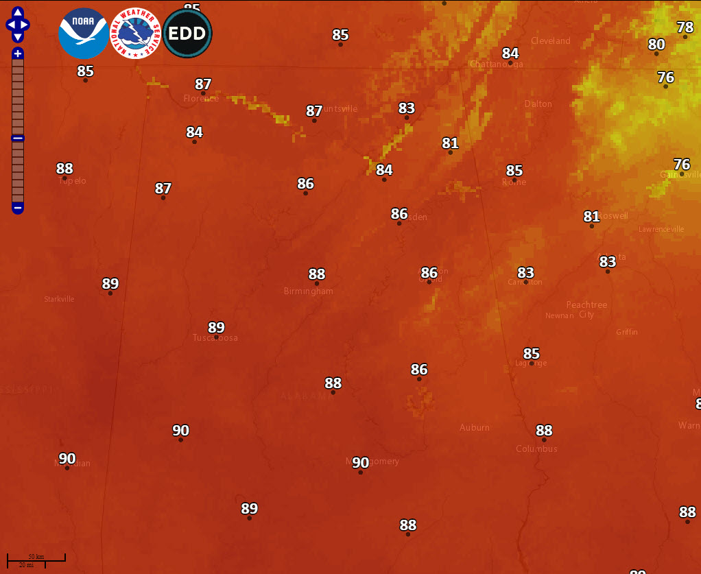
LAST 90F FOR AWHILE? Could we have seen our last 90-degree reading until next Spring? Well, most spots today will be below 90F, although a couple of such readings can’t be ruled out across South Central Alabama. If we get through today, maybe we have seen the last of the 90s until late next spring. We should be in the lower to middle 80s each day this week, with some cooler readings in the 70s by the weekend. Lower 80s should be common that following week. Overnight lows will be in the upper 50s Tuesday morning, with readings in the lower 60s the rest of the week. Saturday morning lows could be in the lower and middle 50s.
RAIN CHANCES: There could be scattered showers across western Alabama later today. A cold front will push into Alabama on Monday, and as a result, rain chances will begin to ramp up tonight, especially over northwestern sections of the state. Those rain chances will ramp up across the entire area Monday morning. The showers should push southeast through the afternoon and mostly be out of the area by late Monday night. A few showers could linger into the morning hours on Tuesday across eastern Alabama, but they won’t amount to much. Wednesday and Thursday look dry, but a few showers could show up by Friday afternoon and be more likely Friday night into Saturday morning. Look for cooler conditions on Saturday, with highs in the 70s.
VOODOO TERRITORY: Much of that following week will be dry, although an approaching front late in the week could trigger a few showers.
GULF COAST WEATHER: Finally, a cool down is heading for the beautiful beaches of Alabama and Northwest Florida. It will arrive by Friday and the weekend. Until then, highs will continue to run in the upper 80s and lows will be in the lower 70s. After that, afternoon readings will trend more back into the upper 70s. The best rain chances will be Monday, but more rain is possible each day through the week. Water temperatures are running about 85 degrees. The rip current risk will be high today and Monday. Otherwise, waves will be running 1 foot or less. Click here to see the Beach Forecast Center page.
TROPICS: The Tropical Atlantic has been worked over for the most part by all the recent hurricanes. The result is much cooler water temperatures across much of the basin. The basin is quiet for now and there are no prospects for tropical development anytime soon. The GFS does spin up a tropical storm or hurricane over the Southwest Caribbean around the 15th.
DANCIN’ WITH THE STATS: New Orleans International Airport broke its all-time record for October for the fourth consecutive day in a row Friday. Yesterday’s high of 92F tied the record high for October 5th.
WEATHERBRAINS: This week, the panel will entertain Todd DeVoe of the EM Weekly podcast. Check out the show at www.WeatherBrains.com. You can also subscribe on iTunes. You can watch the show live at live.bigbrainsmedia.com You will be able to see the show on the James Spann 24×7 weather channel on cable or directly over the air on the dot 2 feed.
ON THIS DATE IN 2005: Parts of North Dakota had up to two feet of snow on the ground from an early season snowstorm that the NWS in Bismarck reported was the earliest major snowstorm on record there. Parts of Interstate 94 were closed through Montana and North Dakota. Ten National Guard soldiers with heavy equipment were out rescuing stranded people. In Minot, a shelter also was set up at an old armory. The Minot Air Force Base required only essential personnel to report for duty. Follow my weather history tweets on Twitter. I am @wxhistorian at Twitter.com.
Category: Alabama's Weather, ALL POSTS
About the Author (Author Profile)
Bill Murray is the President of The Weather Factory. He is the site's official weather historian and a weekend forecaster. He also anchors the site's severe weather coverage. Bill Murray is the proud holder of National Weather Association Digital Seal #0001 @wxhistorianSubscribe
If you enjoyed this article, subscribe to receive more just like it.


