

Finally Some Decent Rain & Cooler Temperatures For Some At Midday
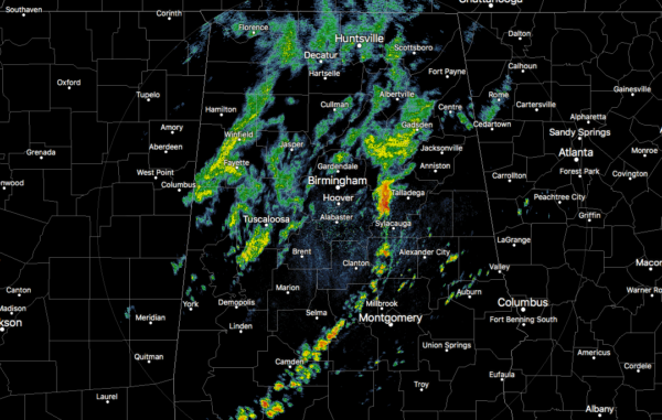
We continue to have a good bit of scattered showers with some heavier rainfall embedded in the front line moving eastward across Central Alabama as we have reached the noon hour on this first Monday of October. The heaviest rainfall is occurring over the western parts of Talladega county. The rest of the rainfall is generally light to moderate in intensity for the most part.
Temperatures are currently in the upper 60s to the lower 80s across Central Alabama. The cool spot was Haleyville at 68 degrees while several were tied as the warm spots at 82 degrees. Birmingham was at 70 degrees.
As the cold front continues to work through Central Alabama, showers and a few thunderstorms will be likely out ahead of it as it moves east-southeast. Afternoon highs will be much cooler behind the front with rain-cooled and drier air, while more humid and warmer air will keep those highs well above normal in the southeastern parts. Highs will be in the upper 60s to the upper 80s from northwest to southeast across the area. For tonight, those shower and thunderstorm chances will start to diminish from northwest to southeast, but a few scattered showers are possible throughout the overnight hours over the southeastern quarter of the area. Lows will be in the mid-50s to the mid-60s from northwest to southeast.
While a few isolated showers & thunderstorms are possible over the eastern-third of Central Alabama, the rest of the area will remain dry with more comfortable temperatures for most at this time of the year. Skies will become mostly sunny and highs will top out in the upper 70s to the upper 80s. Locations in and around Montgomery may make a run at 90 degrees, but hopefully, that doesn’t happen. Those shower chances are less than 20%.
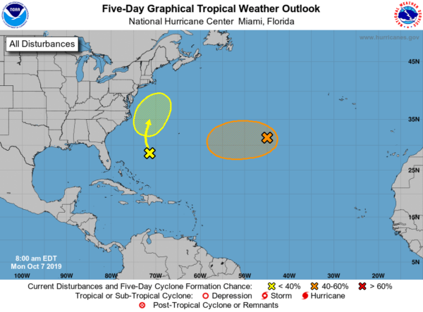
We have two areas to watch out over the open waters of the Atlantic that could gain subtropical characteristics, but at this point, neither one of them look to be a threat to the US. The first is a non-tropical low that is forming between the Azores and Bermuda and is moving to the west. Gradual development could lead to the development of a subtropical storm by Wednesday, but shear will wreak havoc on it and rip it apart. The second area is a disturbance located between Bermuda and the US East Coast. It will move northwestward to start, but a frontal system will force it out and away from the US by the end of the week. It may develop some subtropical characteristics, but a depression is not likely to form. The rest of the Atlantic Basin is quiet.
Category: Alabama's Weather, ALL POSTS
About the Author (Author Profile)
Scott Martin is an operational meteorologist, professional graphic artist, musician, husband, and father. Not only is Scott a member of the National Weather Association, but he is also the Central Alabama Chapter of the NWA president. Scott is also the co-founder of Racecast Weather, which provides forecasts for many racing series across the USA. He also supplies forecasts for the BassMaster Elite Series events including the BassMaster Classic.Subscribe
If you enjoyed this article, subscribe to receive more just like it.


