

Reflecting on Rainfall in Hurricane Hugo: How Storm Speed Affects Rainfall Rates
Thirty years ago on September 22, 1989, Hurricane Hugo made landfall in the United States on Sullivans Island, SC as a category 4 hurricane causing impacts through both North Carolina and South Carolina. Although this storm was a major hurricane on the Saffir-Simpson scale, the amount of rainfall it brought to these areas was significantly less compared to more recent storms that also impacted these areas such as Hurricane Florence in 2018, which made landfall in North Carolina as a category 1. What could have caused this categorically “weaker” storm to have a more significant rainfall-related flooding impact than a major hurricane?
On September 10, 1989, a tropical depression that was soon to become Hugo developed southeast of the Cape Verde Islands. By the next day, this storm had become Tropical Storm Hugo before rapidly intensifying and reaching hurricane strength by September 13. Hugo made its first landfall between Guadeloupe and Montserrat as a category 5 hurricane before making another landfall in St. Croix less than a day later. Hugo then made subsequent landfalls that same day in Puerto Rico. On September 22, Hugo made landfall once again at Sullivan’s Island, South Carolina as a category 4 hurricane with sustained maximum winds of 140mph and a minimum central pressure of 934millibars. The storm weakened rapidly as it moved inland, however, it was still a category 1 by the time it impacted Charlotte, North Carolina the same day as its South Carolina landfall. By September 23, Hugo had weakened to a remnant low and had then dissipated south of Greenland by September 25, 1989.
On August 31, 2018, Tropical Depression Six formed south of Santiago in Cape Verde traveling on a west-northwest trajectory. By September 1st, this storm officially became a named storm as Tropical Storm Florence before undergoing an unexpected rapid intensification September 4th and 5th. At this point, Florence was a category 4 with estimated maximum sustained winds of 130mph and a central pressure of 950millibars. By September 12th, Florence had rapidly weakened due to increasing wind shear, strengthened once again to a category 4, reaching its peak strength of 150mph maximum sustained winds and a central pressure of 937millibars, before dropping back below major hurricane status. On September 14, 2018, Florence made landfall south of Wilmington, North Carolina as a category 1 hurricane with maximum sustained wind speeds of 90 mph and a central pressure of 956millibars. Florence slowly made its way inland, weakening to a tropical depression by September 16th and later dissipating over Massachusetts by September 18th.
(Credit: NWS Weather Prediction Center)
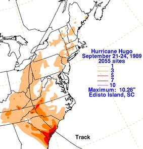
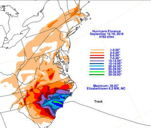
Although both of these storms impacted many areas, including areas outside of the United States, the rainfall-related impacts focused on in this article will be on North Carolina and South Carolina since these were areas greatly impacted by both Florence and Hugo. Hurricane Hugo brought anywhere from 1-10 inches of rain to North Carolina and South Carolina with a maximum rainfall measurement of 10.28 inches in Edisto Island, South Carolina, southwest of Sullivan’s Island where Hugo had made landfall. The majority of heavy rainfall was relatively localized in the southeastern coastal region of South Carolina with many of these areas seeing between 3-7 inches of rain. While Hugo was a major hurricane and was incredibly destructive, it produced significantly less rainfall than the categorically weaker Hurricane Florence. The maximum measured rainfall was 35.93 inches in Elizabethtown, North Carolina. Surrounding areas in central North Carolina to southeastern coastal areas of North Carolina and northeastern coastal areas of South Carolina saw between 10-35 inches of rain during Florence’s time in these areas. Although Florence was a “weak” category 1 hurricane in terms of wind speed and minimum central pressure, the flooding impacts brought on by this intense rainfall were particularly significant. So, how could a category 1 hurricane produce significantly more rainfall in an area and have similarly destructive impacts as a major category 4 storm? The primary key was the speed at which the storms were moving. Hurricane Hugo quickly made its way from its landfall in South Carolina through inland North Carolina within a day while Florence moved at a much slower pace. This slow speed allowed for Florence to continue to produce large amounts of rain in the same areas, leading to significant flooding.
To learn more about other past historic weather and science events from around the world, be sure to click here!
©2019 Meteorologist Stephanie Edwards
AlabamaWX is pleased to partner with the Global Weather and Climate Center team for outstanding posts about our atmosphere. Visit them at https://www.globalweatherclimatecenter.com for more great information!
Category: ALL POSTS, Partner News Stories
About the Author (Author Profile)
Subscribe
If you enjoyed this article, subscribe to receive more just like it.


