

Feeling More Like Fall
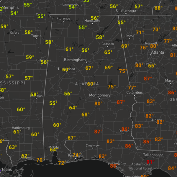
The cold front has pushed into Alabama and has pretty much slowed to a crawl, bisecting the state currently with much cooler temperatures north of the front, where 50s and 60s are more common at midday, while south of the front, 70s and 80s are fairly prominent.
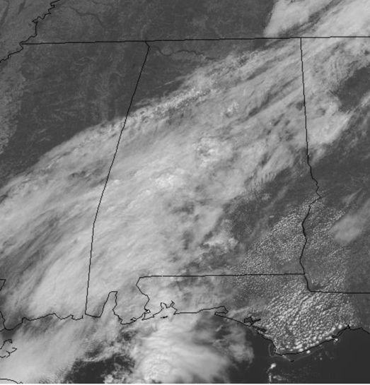
Also, many locations in Central Alabama are seeing mainly cloudy conditions, while there is more sun in northwestern and southeastern potions of the state, on opposite sides of the front. We are seeing a few showers tracking northeast across the central portions of the state as well.
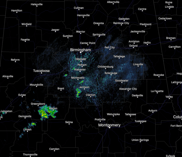
Nothing especially heavy or widespread, but we can expect to continue to see some pockets of showers the rest of today and tonight. For tonight, the clouds will linger along the frontal boundary, and we are going to see a wide range in lows across the state as well. Lower 40s are expected for North Alabama, 50s in Central Alabama, and 60s down to the south.
SUNDAY SHOWERS: For tomorrow, we are expecting it to be mainly cloudy, and moisture will begin to move north over the front to the south and this will cause rain to develop and breakout across the state by the afternoon. We should see periods of light to moderate rain and these are expected into the overnight hours tomorrow. Highs tomorrow will range from the mid 60s to 70s across North/Central Alabama.
SUNDAY, SUNDAY, SUNDAY: For the 1000bulbs.com 500 at the Talladega Superspeedway tomorrow, the sky will be mostly cloudy, unfortunately it looks like rain is likely by afternoon. The temperatures at the track will hover in the upper 60s much of the day.
IN THE TROPICS: Most of the Atlantic continues to be quiet, but the season continues until November 30th. We do have Sub-tropical Storm Melissa and a couple of areas of interest, but we are also getting to that point in the season where things gradually quiet down.
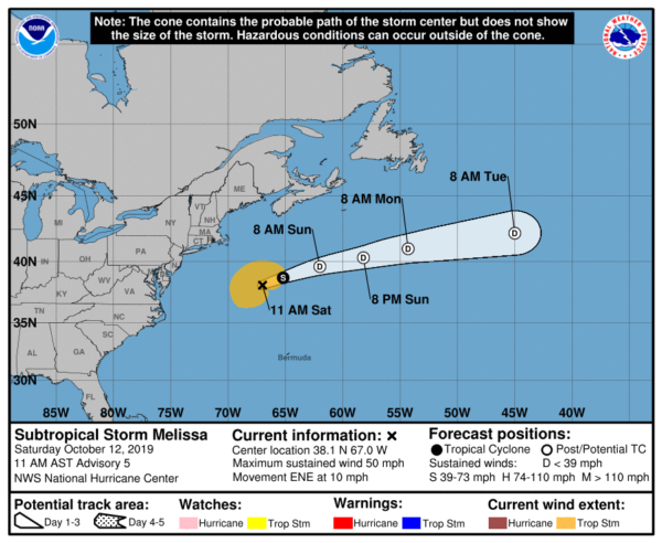
At 1100 AM AST, the center of Subtropical Storm Melissa was located near latitude 38.1 North, longitude 67.0 West. Melissa is moving toward the east-northeast near 10 mph. A gradual increase in forward speed is expected tonight through Monday. On the forecast track, Melissa will continue to move away from the U.S. Mid-Atlantic and New England coasts.
Maximum sustained winds are near 50 mph with higher gusts. Slow weakening is expected today, with a faster rate of weakening tonight. Melissa is forecast to become a post-tropical remnant low by Sunday. The estimated minimum central pressure is 998 mb (29.47 inches).
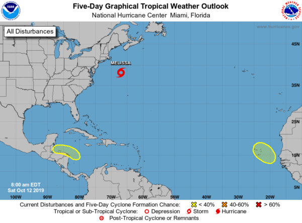
ELSEWHERE: A broad area of low pressure is expected to form over the southwestern Caribbean Sea this weekend. The system is forecast to move westward toward Central America early next week, and some development is possible if the low moves over the northwestern Caribbean Sea near the coasts of Honduras, Guatemala, and Belize. Regardless of development, this system could bring heavy rains to portions of Central America late this weekend through early next week.Formation chance through 5 days…low…20 percent.
A tropical wave, accompanied by a broad area of low pressure, is expected to move off the west coast of Africa on Sunday. Although tropical cyclone formation in this area is climatologically unlikely this late in the hurricane season, some development of the system is possible before conditions become unfavorable by the middle of next week. The system is expected move westward to northwestward toward the Cabo Verde Islands during the next several days. Formation chance through 5 days…low…30 percent.
BEACH FORECAST CENTER: Get the latest weather and rip current forecasts for the beaches from Fort Morgan to Panama City on our Beach Forecast Center page. There, you can select the forecast of the region that you are interested in visiting.
WORLD TEMPERATURE EXTREMES: Over the last 24 hours, the highest observation outside the U.S. was 116.6F at Rafha, Saudi Arabia. The lowest observation was -88.6F at Vostok, Antarctica.
CONTIGUOUS TEMPERATURE EXTREMES: The highest observation was 101F at Santa Ana National Wildlife Refuge (McAllen), TX. The lowest observation was -2F at West Yellowstone, MT.
WEATHER ON THIS DATE IN 1918: Forest fires ravaged parts of Minnesota from the Duluth area northeastward, claiming the lives of 600 persons. Smoke with a smell of burnt wood spread to Albany NY and Washington D.C. in 24 hours. Smoke was noted at Charleston SC on the 14th, and by the 15th was reported in northeastern Texas.
Category: Alabama's Weather, ALL POSTS
About the Author (Author Profile)
Macon, Georgia Television Chief Meteorologist, Birmingham native, and long time Contributor on AlabamaWX. Stormchaser. I did not choose Weather, it chose Me. College Football Fanatic. @Ryan_StinnetSubscribe
If you enjoyed this article, subscribe to receive more just like it.


