

A Quick Look At The Tropics… Melissa Is Now Extratropical
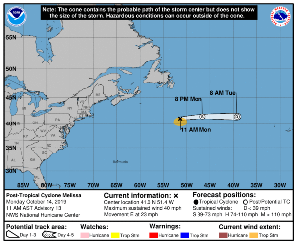
MELISSA: SUMMARY OF 1000 AM CDT INFORMATION
LOCATION…41.0N 51.4W
ABOUT 405 MI…650 KM SSE OF CAPE RACE NEWFOUNDLAND
MAXIMUM SUSTAINED WINDS…40 MPH…65 KM/H
PRESENT MOVEMENT…E OR 80 DEGREES AT 23 MPH…37 KM/H
MINIMUM CENTRAL PRESSURE…1004 MB…29.65 INCHES
Melissa has transitioned to an extratropical cyclone. Shallow convection has become displaced greater than 100 n mi from the center, and Melissa’s circulation has become embedded within a frontal zone. The inner-core now consists of a swirl of low clouds with a large amount of cool post-frontal stratocumulus wrapping into the northern and western portions of the circulation. A recent ship report just southwest of the center indicated gale-force winds are still occurring in association with Melissa, and 35 kt will be this advisory’s initial intensity. The extratropical cyclone is expected to gradually weaken over the next day or so, and dissipate before it reaches the Azores.
Melissa is now moving at 080/20 kt and is embedded within mid-latitude westerlies. This general motion is expected to continue until the cyclone dissipates. The National Hurricane Center will not be issuing any more updates on Melissa.
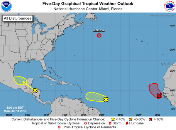
A large low-pressure system located over the far eastern tropical Atlantic Ocean about 300 miles southeast of the Cabo Verde Islands is moving slowly west-northwestward. Showers and thunderstorms are showing some signs of organization, and environmental conditions are expected to be conducive for a tropical depression to form during the next day or so while the disturbance moves west-northwestward to northwestward near the Cabo Verde Islands. Strong upper-level winds should prevent any further development by midweek. This system is forecast to bring locally heavy rainfall and gusty winds to portions of the Cabo Verde Islands later today through Tuesday. Formation chance through 48 hours is high at 80%.
Disorganized showers and thunderstorms over the southwestern Caribbean Sea, Gulf of Honduras, and parts of Central America are associated with a broad area of low pressure located inland over north-central Honduras. This system is expected to move west-northwestward across Honduras, southern Belize, and northern Guatemala, which should prevent tropical cyclone formation for the next couple of days. By Wednesday, however, the low is forecast to emerge over the southern Bay of Campeche where conditions could become a little more conducive for some organization to occur. Regardless of development, this system is expected to produce heavy rains over portions of Central America during the next few days, which could cause flooding and mudslides, especially in mountainous areas. Formation chance through 5 days is low at 20%.
A tropical wave located over the central tropical Atlantic is producing disorganized cloudiness and thunderstorms. While thunderstorm activity has increased since yesterday, upper-level winds are not particularly conducive for significant development of this system over the next couple of days while it moves westward at around 15 mph. By Wednesday, as the wave approaches the Windward Islands, upper-level winds are forecast to become quite hostile for any further development. Formation chance through 5 days is low at 10%.
About the Author (Author Profile)
Scott Martin is an operational meteorologist, professional graphic artist, musician, husband, and father. Not only is Scott a member of the National Weather Association, but he is also the Central Alabama Chapter of the NWA president. Scott is also the co-founder of Racecast Weather, which provides forecasts for many racing series across the USA. He also supplies forecasts for the BassMaster Elite Series events including the BassMaster Classic.Subscribe
If you enjoyed this article, subscribe to receive more just like it.


